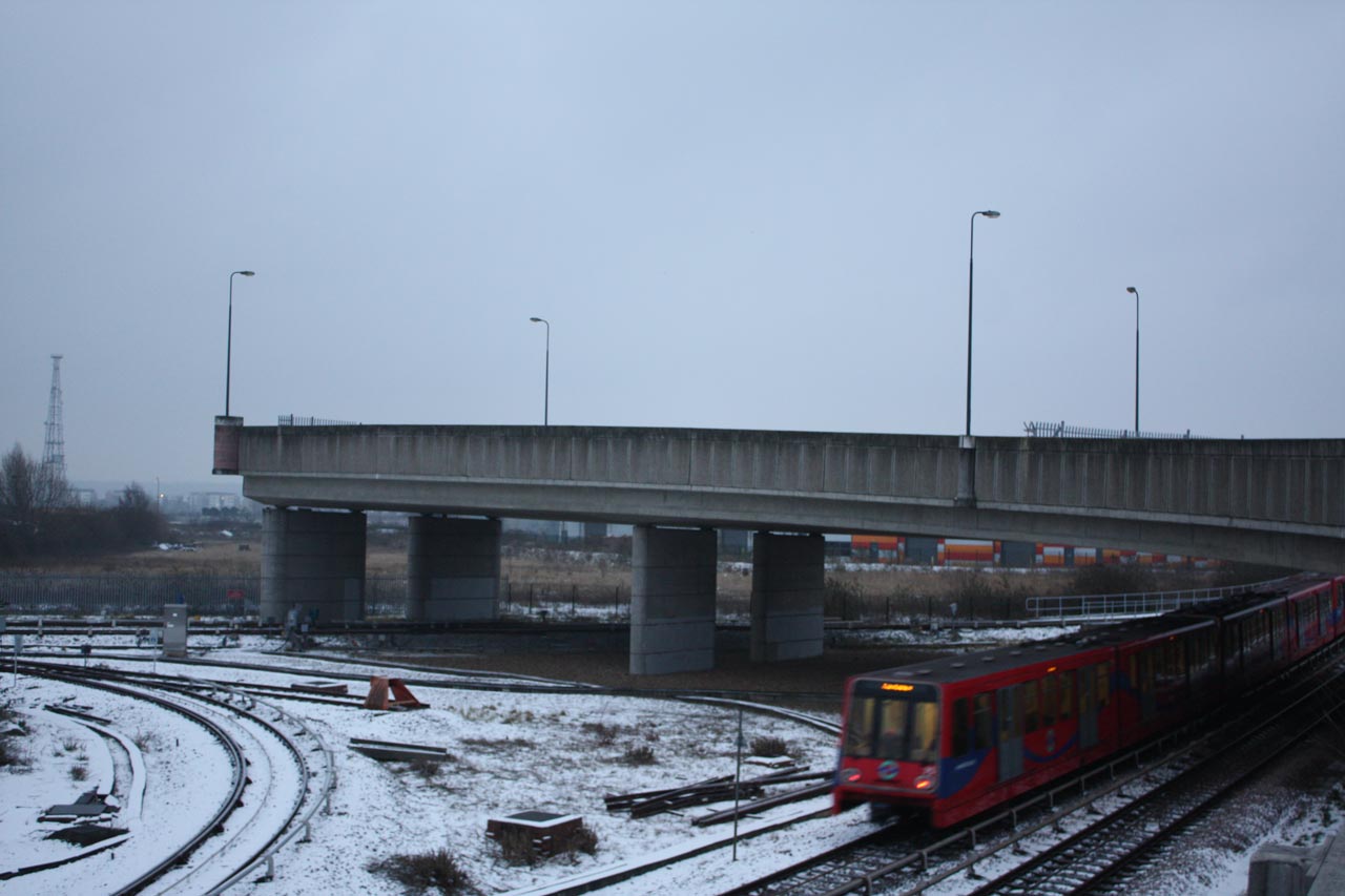
The bridge going nowhere in the photo above is known as the ski jump. It’s a section of road over in Beckton that was built in preparation for the Thames Gateway Bridge, but currently leads to nowhere apart from a dangerous drop. Maybe it’s a metaphor …
I’ve been enjoying reading about the various attempts to create a river crossing between Thamesmead and Beckton over the last few days. It’s a fascinating tale: from the Ringway suggestion back in the 1930s which became Ringway 2 in the 1960s, then the East London River Crossing in the 1980s and 90s, the Thames Gateway Bridge early this century and now TfL’s Gallions Reach Ferry proposal and the Royal Borough of Greenwich’s campaign for a bridge.
The historical background and story of People Against the River Crossing is well told in David Black’s “The Campaign to Save Oxleas Wood” which details the inquiries and court cases, both UK and European, that eventually led in 1995 to the dropping of plans to put a motorway through Oxleas Wood and Plumstead and build the East London River Crossing. A group of local residents known as the Oxleas Nine risked financial ruin from huge legal fees to appeal to the High Court against the compulsory purchase orders needed to allow the roads and crossings to be built.
Unfortunately the documents relating to the 2005 Thames Gateway Bridge Public Enquiry are no longer available online, but those I have seen show a similar level of opposition from local residents concerned about issues such as the health effects of air pollution and the risk to Oxleas Wood from the need for improved road links to the A2.
My reading about the bridge also led me to the Beckton ski jump. It can be seen circled in red on the Google Maps snippet below; it is also one of the possible routes for traffic to TfL’s proposed Gallions Reach Ferry. Its other claim to fame is that it appeared in a car chase in the TV series Bugs, which culminated in a car driving off the end of the ski jump to explode in the waste land beyond. It’s on YouTube here, starting at about 46minutes in.

The map also shows another complication to building a bridge here – the proximity and orientation of the runway at London City Airport, which limits the possible height of the bridge. Campaigners in favour of east London river crossings make much of the disparity in the number of crossings to the west and east of Tower Bridge. Two obvious reasons for the difference are that the Thames is wider the nearer it gets to the sea, and large ships sail up the Thames to Central London (and potentially to a cruise liner terminal in Greenwich). Consequently bridges need to be wider and higher and are more expensive to build, which seems to lead to them having to carry more traffic. The artists impressions of the proposed Thames Gateway Bridge, below, from TfL’s brochure show the likely size of a bridge at this location.
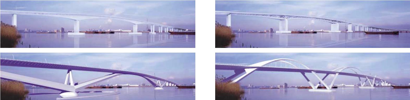
The required height of the bridge means that it has to have longer run-up roads so the overall length is much longer than just the distance across the river, making it very pedestrian unfriendly. Not to mention the high winds in the middle.
When I started writing this post I intended to focus on traffic modelling. I’m not an expert, but it seems to me that changes to the road infrastructure need to consider the whole network because increasing capacity in one place will simply move the bottlenecks to somewhere else in the network, so improvements should be across multiple sites to try to even out the flows. Also traffic management measures need to be included to discourage cars and lorries from small, residential roads. I’m still searching for some comprehensible detail on modelling, but I notice that the recently released East London River Crossings Assessment of Options mentions this issue and confirms my feelings about the impact that a Gallions Reach bridge would have on roads through Plumstead and Bexley:
6.285. The modelling for TGB suggested that it would provide relief for the Blackwall tunnel as well as opening up new travel opportunities further to the east. However, a key issue is that the road network on the southern side is much less developed than on the northern side, where the road would meet the grade separated A406 and A13 as well as linking (via the A406) to the M11.
6.286. To the south, the road would meet the east-west South Thames Development Route, a useful distributor road along the southern side of the Thames, but this is lower capacity than the northern access routes, and is generally not grade separated, with congested junctions in Plumstead, Woolwich and Erith.
6.287. Other routes on the southern side are poorer still, with the roads south into Bexley being largely two lane single carriageway roads, fronted by suburban housing. There was some strong local opposition to the scheme arising from concerns over the impacts in these areas. This led ultimately to the opposition of the London Borough of Bexley to the scheme.
This suggests that a ferry at Gallions Reach would be a better option than a bridge because there is a natural capacity limiting effect from a ferry that will reduce the amount of traffic heading in that direction, though additional action to encourage traffic along suitable roads and away from smaller roads may be needed too. And by analogy with west London perhaps having many smaller scale crossings would be better than one or two massive congestion generating grand projects like multi-lane bridges and tunnels; an argument in favour of keeping the Woolwich Free Ferry as well as the new one. I’d be interested to see the results of traffic modelling with this scenario.
Are there any other possibilities for small east London river crossings, I wonder, and what is the current state of technology for swing bridges?
We have until 1st February to make any comments on the Transport for London proposals using an online survey with just 14 questions, or by e-mail to rivercrossings@tfl.gov.uk. There is also an online petition against the Silvertown tunnel.
Friends of the Earth have arranged two public meetings about the crossings – one north of the Thames tonight and another at the Forum in Greenwich next Monday, 28th. They e-mailed with the details:
North side of the river:
Monday 21 January 2013, 7-9 p.m.
St Matthias Community Centre, 113 Poplar High Street, E14 OAE
http://www.stmatthiascommunitycentre.com/contactus.jsp
Nearest station: Poplar DLR
South side of the river:
Monday 28 January 2013, 6.30-8.30 p.m.
Forum@Greenwich, Trafalgar Road, Greenwich, London SE10 9EQ
Nearest station: Maze Hill stationSPEAKERS:
-Air Pollution expert Dr Ian Mudway of Kings College London
-Transport expert John Elliott, Transport Consultant

