Ye who have a spark in your veins of cockney spirit, smile or mourn acccording as you take things well or ill;— Bold Britons, we are now on Shooter's Hill!
Apologies for the lack of website lately, for some reason the site experienced more traffic in one day (april the 20th), than it normally does in two months, which didn’t go down too well with the host. It was probably something to do with the post on Dickens, anyway the site trundles on.
This latest bit of hilliana, by Charles Dickens, was stumbled across in the Shrewsbury House Library, and since the copyright has expired it’s reproduced in part here. This scene takes takes places in 1775, but it’s worth bearing in mind that the serialisation of the story began in 1859, so it’s not necessarily a historically accurate account of the hill at that time, it is however Dickens at his (late era) best:
II. The Mail
It was the Dover road that lay, on a Friday night late in November, before the first of the persons with whom this history has business. The Dover road lay, as to him, beyond the Dover mail, as it lumbered up Shooter’s Hill. He walked up hill in the mire by the side of the mail, as the rest of the passengers did; not because they had the least relish for walking exercise, under the circumstances, but because the hill, and the harness, and the mud, and the mail, were all so heavy, that the horses had three times already come to a stop, besides once drawing the coach across the road, with the mutinous intent of taking it back to Blackheath. Reins and whip and coachman and guard, however, in combination, had read that article of war which forbade a purpose otherwise strongly in favour of the argument, that some brute animals are endued with Reason; and the team had capitulated and returned to their duty.
With drooping heads and tremulous tails, they mashed their way through the thick mud, floundering and stumbling between whiles, as if they were falling to pieces at the larger joints. As often as the driver rested them and brought them to a stand, with a wary “Wo-ho! so-ho-then!” the near leader violently shook his head and everything upon it—like an unusually emphatic horse, denying that the coach could be got up the hill. Whenever the leader made this rattle, the passenger started, as a nervous passenger might, and was disturbed in mind.
There was a steaming mist in all the hollows, and it had roamed in its forlornness up the hill, like an evil spirit, seeking rest and finding none. A clammy and intensely cold mist, it made its slow way through the air in ripples that visibly followed and overspread one another, as the waves of an unwholesome sea might do. It was dense enough to shut out everything from the light of the coach-lamps but these its own workings, and a few yards of road; and the reek of the labouring horses steamed into it, as if they had made it all.
Two other passengers, besides the one, were plodding up the hill by the side of the mail. All three were wrapped to the cheekbones and over the ears, and wore jack-boots. Not one of the three could have said, from anything he saw, what either of the other two was like; and each was hidden under almost as many wrappers from the eyes of the mind, as from the eyes of the body, of his two companions. In those days, travellers were very shy of being confidential on a short notice, for anybody on the road might be a robber or in league with robbers. As to the latter, when every posting-house and ale-house could produce somebody in “the Captain’s” pay, ranging from the landlord to the lowest stable non-descript, it was the likeliest thing upon the cards. So the guard of the Dover mail thought to himself, that Friday night in November, one thousand seven hundred and seventy-five, lumbering up Shooter’s Hill, as he stood on his own particular perch behind the mail, beating his feet, and keeping an eye and a hand on the arm-chest before him, where a loaded blunderbuss lay at the top of six or eight loaded horse-pistols, deposited on a substratum of cutlass.
The Dover mail was in its usual genial position that the guard suspected the passengers, the passengers suspected one another and the guard, they all suspected everybody else, and the coachman was sure of nothing but the horses; as to which cattle he could with a clear conscience have taken his oath on the two Testaments that they were not fit for the journey.
The above is just a snippet of the chapter although subscribers will have got the thing in their email/syndicator, to read the whole book, click through to project gutenberg ebook #98.
Shooters Hill Against Masts - click to zoom and read the planning application
Mobile masts are something of a blot on the landscape, but are they are blot on sleep and other biological processes too? In recent years mobile operators have been busy improving their coverage in this area, with a growing collection of hilltop antenna, comprised of mobile, shipping, and most controversially emergency services base stations.
A recent TETRA related planning consultation period that expired on February the 17th has perhaps rather late in the day caused something of a stir. The mast is on eaglesfield road near the fire station. The opposition to proposals for the upgrading of equipment owned by airwave solutions has led to mo burgess of the greenwich conservatives writing to residents to survey local feelings on this topic; she explains in her letter that she has received a number of complaints. More recently, a number of posters have gone up on lamp posts in the area, with a couple of contact phone numbers at the bottom, not having rung them myself I’m not sure if they are to do with mo burgess.
Base stations in general are unpopular, partly because some of the masts are so menacing to look at, but airwave equipment in particular is seen as somewhat controversial because of the comparatively higher health risks thought to be associated with the encrypted TETRA radio specification they use. Firstly there’s the slow cooking problem, which relates to both those near base stations and handset users (in this case ambulance workers, firefighters and the police). Additionally there are the so called non-thermal effects associated with TETRA. The story about base station risks is fairly complex (i.e. I couldn’t fully grasp the main literature review after one very boring sitting), but it does seem that the continual repetition of signal oscillations at around 17Hz might (to me) be the mechanism behind the sleep disturbances reported in some of the survey findings, although the so-called nocebo (negative) effect can’t necessarily be ruled out in that study due to the way it was set up. This all led me to speculate that since neural firing patterns oscillate around 11-39Hz during open eyed wakefulness and 2-7Hz during sleep, a constant stream of 17Hz signal frequencies pulsing through ones bedroom wall and head at night could potentially induce wakefulness?
The experiments on the topic is divided into two camps, and Epidemiologists haven’t really been able to investigate TETRA yet as they probably need more time (they are now going over >10 year data for GSM and even that has been divisive). The general scientific consensus seems to be that more long-term adverse health affects have not been ruled out for this technology, and with the previous concerns over some of the signal frequencies and microwave radiation used in TETRA, the response of some people is quite reasonably, “Why should we be the guinea pigs!”
I got my first air quality warning from airtext.info today, after three whole months of London air quality giving no cause for alarm!
The london air quality network, who recently released a popular updater for iphones have reported a couple of moderate particulate readings as a result of light southeasterly winds bringing particles over from Europe coupled with the build up of traffic emissions during a cold and foggy night over here. Their highest readings tend to coincide with guy fawkes night!
Anyway apart from thinking about how dirty London is, here’s a nice rose plot of the 2009 average wind direction (in degrees from north) and speed (in meters per second) of readings taken from the falconwood site. I had always thought that the prevailing wind came from mexico (roughly 210°-240°), and usually the kites in blackheath do catch that breeze… but judging by the data (which are apparently to interpreted with some caution due to obstructions) the easterly wind (90°) seems to be the strongest, presumably it whistles up the thames all the way from siberia, brrr!
Wind direction/speed over the last seven days
** Update ** for a bonus, which is mainly useful to those who are wondering where a case of what the daily mail infamously referred to as ‘le/der stink‘ might be coming from, here’s an updater that retrieves the wind data for the last seven days.
The triangular, three-storey Grade II* listed castle stands on the top of Shooters Hill where it is a local landmark. Built in 1784, it commemorates a long-forgotten British naval victory against pirates marauding in the Indian Ocean. Closed to the public for 20 years, it was identified as a key project for repair in the BBC TV series Restoration in 2004 but failed to reach the finals. Thanks to the HLF grant it will be restored as a visitor attraction, educational centre and tea room. It will be run by a local trust and volunteers will be trained to act as guides, to staff the café and to assume the day-to-day management of the castle as well helping at future heritage events.
David Goodfellow of the Severndroog Castle Building Preservation Trust said:
“We are delighted with the confirmed award from HLF, which is a major step forward in achieving our objective of restoring this unique building. There is still plenty of hard work to be done but this decision, together with grant funding support from a number of other organisations as well as significant support from Greenwich Council and the local community, has greatly increased our sense of optimism about reopening a fully-restored Severndroog Castle to the public.”
According to the mercury the £595k amounts to 70% of the total required (595000÷.7=£850k) so that leaves 255k to go, minus the £1,573 raised by sponsor a brick for severndroog = £253,427 left to go… although that particular arm of the campaign has the aim of raising £50k.
This is a significant move by the Lottery considering that that last time they earmarked money for the campaign it was for the comparatively smaller amount of £250k November 2008. It was additionally interesting to note that after Camden, Greenwich benefits from the most lottery heritage money, so I think this is a timely reminder to get behind the campaign at the grassroots level and buy your loved ones a brick (well, a sponsor’s certificate)!
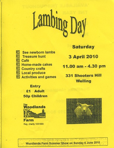
Woodlands farm are about to present the first of their 4 annual events, the peak of lambing season! The event is on saturday april the 3rd from 1100-1630. hope to see you there.
Today I received some campaign materials from Clive Efford MP, which included the news that Eaglesfield Park is going to have its own Open Air Gym (?!) and improved signs and paths in order to meet the criteria for the prestigious Green Flag Award.
The concept of an open air gym seems quite strange to me as I’ve become happily accustomed to the idea of people getting their endorphins behind closed doors on those bizarre W. Heath Robinson style contraptions that allow you to run nowhere, lift nothing and so on – walking the streets is certainly much more pleasant now than it was at the height of the jogging craze; these days I can happily amble around in a reverie without sweaty spandex clad neurotransmitter freaks huffing and puffing at me from all directions.
The money itself is going to come from an Olympics Legacy fund. I assume the idea is to use the events to enthuse local people about sport at the same time as giving them an outlet for all their newfound enthusiasm – this is the legacy, and surely a good thing if it gives people something to do other than moan about the bankers nicking all our money. I’m personally looking forward to the target sports at the artillery barracks, and will be watching as much Robin Hood as I can in the run up to the games. I’m not sure if local people will be able to get tickets though, quite possibly not, and even if they can I’ve heard that they change hands for thousands of pounds.
As for the Green Flag award, it sounds quite good considering the recognition that the Plumstead Common Environment Group have earned as a result of their award winning restoration of the Slade Ponds. It certainly bodes well for the Lily Pond plans as being able to write “Green Flag Status” on grant applications helps to make a good impression on the potential future funders by demonstrating that there is a precedent of time and money being invested in the park.
Highway safety seems to be fairly active theme in the area at the moment, there was the traffic monitoring in cleanthus road last year (not sure what came of that), and the extension of the 20 mph zone to eaglesfield road; now there’s a new speed/vehicle counter on the hill going down to kent, plus the occasional traffic police with lidars round the garden centre, and the new road safety improvements to shrewsbury lane where it meets the main road plus the pedestrian refuges at various stages, and the proposed double yellow lines on the main road round the farm (this will save people getting parking fines when they drive to the lambing day in april)…
Overall it just goes to show that gene selection for fear of spiders and snakes, useful though it may have been in the ancestral environment, is now being replaced by meme selection – i.e. we’re just not scared enough of vehicles yet, so culture has to intervene whilst we wait for the genome to catch up (i.e. all the people who are afraid of cars reproduce more effectively than those who aren’t).
In 2000 Red Lion Lane benefited from traffic calming as part of the 20mph traffic calming measures enjoyed by many roads in the area, and was also turned into a down-the-hill-only road at the top end. At the same time the idea of excusing pavement parking on the bottom end was briefly considered before being, erm, parked. Since then the council have received a number of complaints about drivers having difficulty passing each other on this lower section of the lane, and also complaints about damage to parked vehicles, which presumably happens when things get tight. Efforts have been made to revive the pavement parking idea, but now a more radical measure is being proposed which is to make still more of the lane down hill only.
A mini vote is currently on, mainly to sound out the feelings of those who live on roads that will get the up-hill traffic that currently use red lion lane as a rat run when the junction at the old shooters hill police station gets slow, and so I anticipate that herbert road→paget rise→ankerdine crescent→shrewsbury lane→foxcroft road→eaglesfield road will now become the cut through of choice for those in an, erm, hurry. The other way that through traffic might cut through would be herbert road⇒ripon road⇒eglinton hill⇒eaglesfield road – so it may be that residents in these roads are being polled.
You may have noticed some road works going on around the bull, this is something to do with safety improvements being made to various places along the hill. What I’m just about to reveal was first mentioned on the neighbourhood watch website which now boasts a shiny new design and has changed to cover the shooters hill police ward, presumably in line with its links to the met, which incidentally has a rather whizzy map based site about crime in the area; did you know that this ward has one of the lowest crime rates in the borough.
The changes due to take place are as follows:
Provision of an ‘entry treatment’ at the junction of Shrewsbury Lane and Shooters Hill. This will hopefully reduce the number of recurrent collisions with drivers turning out of Shrewsbury Lane on to Shooters Hill.
Installation of ‘SLOW’ carriageway markings and red-coloured surfacing on Shooters Hill at the junction with Eaglesfield Road. This in turn should alter driver perception and encourage reduced speed.
Installation of a pedestrian refuge island east of Cleanthus Road, very near the water tower. This will provide a safe crossing for people using the bus stops near Eaglesfield Road.
Installation of a pedestrian refuge island near Woodlands Farm. This will provide a safe crossing for people visiting Woodlands Farm and the bus stop located opposite on Shooters Hill.
Installation of five traffic islands on Shooters Hill towards Welling, in addition to red-coloured surfacing within the central hatching from Shrewsbury Lane to the Greenwich-Bexley Borough Boundary.
Installation of a ‘Speed Warning Sign’ on the traffic island near Woodlands Farm.
Let’s hope it works! I personally feel that these changes could have taken the side of the pedestrian a bit more than they did, but there might be a good reason for keeping the traffic moving.
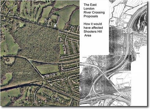
July the 8th 1993, central government withdraws the Oxleas Woods section of its infamous Roads to Prosperity scheme. The hill is saved!
I’ve been asked whether I’d like to investigate this, and since this is quite possibly one of the most significant things to ever happen here, it seems like a good idea for this site to cover this part of the Shooters Hill story.
Since this is a relatively recent episode, and an example of people power, I’m hoping to include some thoughts from those who participated in and observed the saving of the woods. So, if you were there, and would like to reminisce, I would like to hear from you. If you are interested please get in touch via the email address at the foot of the page.
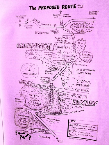
The map shows how the bypass would have run right through woodlands farm, oxleas wood, and sheperdleas wood to meet the a2
At some point this year a post on this will appear, but for the time being, here’s the oxleas section of an alarm uk publication from 1995 (taken from the limited online information I’ve found so far):
“Whenever I used to visit Oxleas Wood I would visualise the proposed road cutting through it. It’s hard to believe that the woods are now safe. But safe they almost certainly are!
My involvement in the campaign against the East London River Crossing began in earnest in the late eighties. By this time the road had been scheduled for construction for many years and had already been approved by the longest Public Inquiry ever held into a road scheme. That inquiry had lasted 194 days; the transcripts of the proceedings contained 9.5 million words!
Local people, in the form of People Against the River Crossing (PARC) and Greenwich & Lewisham FOE, were fighting a determined and exhausting battle against a scheme which would not only cut a swathe through 8,000 year old Oxleas Woods but would also take out several hundred houses in the quiet and pleasant suburb of Plumstead. But with approval in principle granted, and with the Government, developers and some socialist local authorities strongly supporting the scheme, the odds against stopping it were getting bigger all the time. To achieve victory, a concerted strategy was needed to make Oxleas Wood a big issue locally and give it wider significance – a strategy to make it a symbol of the environmental damage that the road programme was causing and a rallying point for the environment movement. If that could be done, then, given Oxleas Wood’s proximity to Westminster, it might force the Government to back down rather than risk confrontation with a united community and environment movement, in its own “back yard”.
Like all the best campaigns we fought on every level. There were letter-writing stalls at the popular Greenwich market, politicians were systematically lobbied and a well-presented public transport alternative was drawn-up. We organised an “Adopt-a- Tree” scheme; the aim here was to get every tree in Oxleas Wood adopted. As well as bringing in funds and publicity, it would give supporters a real stake in the campaign. And if the worst came to the worst we could invite tree adopters to turn up to defend their tree.
In order to make Oxleas a “line in the sand” for the environment movement, we got some of the large environmental non-government organisations (for example the Wildlife Trusts and World Wide Fund for Nature) to take part in an Oxleas Strategy Group. This helped lock them into a campaign that was ultimately run by local people, but which made the best use of the resources of the national campaigns.
A couple of legal lines of last resort helped propel the campaign into the national news. The Government had failed to carry out an Environmental Impact Assessment for the scheme, as required by European Community law. The heroic European Commissioner for the Environment, Carlo Ripa di Meana, took up this complaint causing Prime Minister Major to hit the roof and interrupt a Commonwealth conference to condemn the EC’s action. The complaint was never seen through by the EC, but the publicity was invaluable, as was that which resulted from a High Court case where the “Oxleas 9” (nine local people) put their assets on the line to take the Department of Transport to court over their failure to provide adequate land in exchange for the damage to Oxleas woods. The case was lost, but Oxleas had caught the public imagination and the pressure on the government was intensifying.
Meanwhile, campaigners were preparing for the worst. A “Beat the Bulldozer” pledge was launched, with the aim of getting 10,000 people to pledge to be there if the bulldozers went in. With the TV pictures of direct action at Twyford Down fresh in their minds, as well as the vivid pictures we had painted of what would happen if they violated Oxleas Wood, the Government backed down.
For me the Oxleas campaign had meant hours of hard work in meetings held in draughty halls on dark, rainy nights trying to get the best campaign that I could. For hundreds of local people it had been years of struggle. Was it worth it? Definitely. Oxleas was a turning point. We’d shown how people power could stop roads, a lesson that was quickly learnt right across the country. We’d shown that the environment movement, when it’s focused and working in harmony with local communities, could win. And of course the peace and beauty of OxleasWood has been preserved.
Jonathan Bray, founder and convenor of the Oxleas strategy group
The Hedgerow on the eastern side of the meadow is composed of mainly hawthorn (Crataegus spp) with some self-seeded oak. This hedgerow is rather special as it contains some examples of butchers broom (Ruscus aculeatus), which is used as an indicator of ancient woodland, as it rarely grows in regenerated woodland. It was the presence of this plant that aided the campaign to stop the East London River Crossing putting a road through Oxleas Wood. This hedgerow was re-laid in 2004 by the GLLAB New Deal project.


