Ye who have a spark in your veins of cockney spirit, smile or mourn acccording as you take things well or ill;— Bold Britons, we are now on Shooter's Hill!
Spring has sprung at last and our green spaces are shooting and blooming. Parts of Oxleas Wood are carpeted with Wood Anemones, and the first Bluebells have appeared. Next Sunday, 5th May, there are two opportunities to enjoy a walk in our woodlands guided by experts.
In the morning, starting at 10.15am Woodlands Farm are hosting a Late Spring Wildlife Walk. As their poster says:
Sunday 5th May 2013 10.15am – 12.30pm
Winter was not behind us when we had our last spring walk. But at last the blossom is out in the hedgerows and lambing is finished! So put a spring in your step and enjoy a community countryside and wildlife walk around Woodlands Farm. Led by members of the Woodlands Farm Trust. Please wear appropriate clothing including sensible footwear. The walk will probably be a bit challenging for buggies but supervised children are very welcome.
£1 per person (under 18’s free)
Free for farm volunteers and members
Meet at the Education Centre
The Woodlands Farm Trust
331 Shooters Hill, Welling, Kent DA16 3RP
Website: www.thewoodlandsfarmtrust.org
Email: wildlife@thewoodlandsfarmtrust.org
Tel: 020 8319 8900
Then in the afternoon, meeting at 2.00pm at the Oxleas Cafe, there’s a Bluebell Walk guided by the London Wildlife Trust. If it’s anything like last year’s walk participants will learn about much more of the flora and fauna of Oxleas Wood than just the Bluebells. It is expected that the walk will last 1 to 2 hours, but participants can join or leave at any time.
Those who have lots of energy could do both walks, maybe fortified by a bacon butty from the Oxlea Wood Cafe.
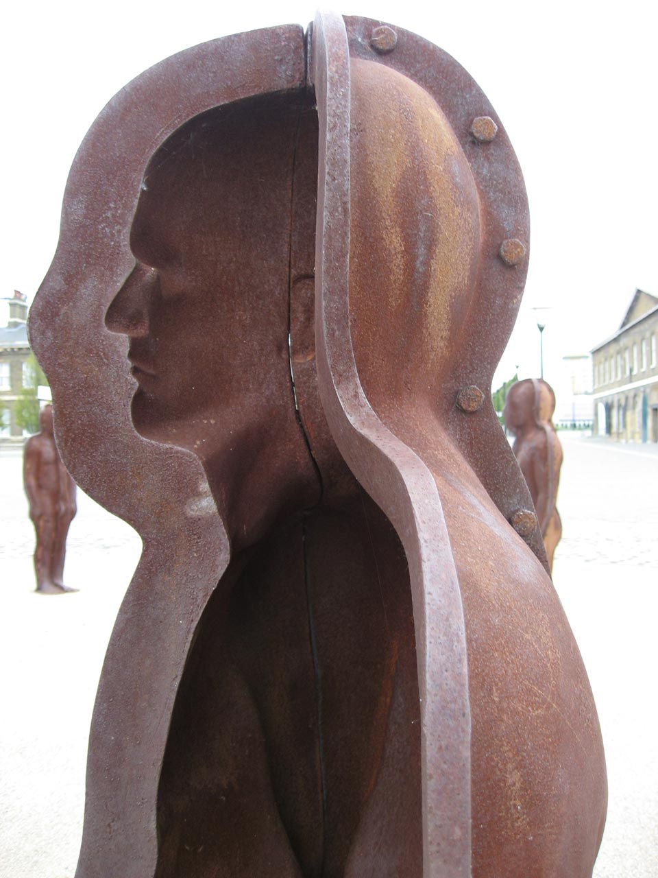
Detail of Assembly by Peter Burke in the Royal Arsenal
Commenting on the Royal Borough of Greenwich Draft Core Strategy is hard work. It’s not just that the Strategy itself is 235 pages of planner-speak, but there are also a large number of supporting documents, such as the Sustainability Appraisal and the Tall Buildings Assessment. Some of them, like the Areas of High Archaeological Potential document and the Biodiversity Action Plan, are quite interesting but still a lot of information to try to assimilate.
But it has to be done, even if these consultations seem to be cynical. The Core Strategy and other documents that make up the Local Plan will be the basis of planning decisions in Greenwich until 2028 ao it’s important that they are right. The strategy is wide-ranging. For example it proposes building an additional 32,235 houses in the borough by 2027 – the population is expected to increase by 22.5%, more than a fifth, from 2010 levels to 288,000 by 2027. It also enshrines support for the Silvertown Tunnel in policy C3, critical transport infrastructure. But it doesn’t mention betting shops anywhere.
The current consultation is the last opportunity for public involvement in deciding the planning strategy before it is submitted to the Planning Inspectorate. The Planning Inspectorate will then chair a formal “Examination in Public” (EiP), which is likely to be a number of round table hearings depending on the volume of comments. However only people who have made comments at this stage of the process, and who have indicated that they want to attend, will be able to participate.
The London Tenants Federation have been holding workshops to help tenants and other community groups to influence planning policy. For example, providing guidance on how to make comments on the Greenwich Core Strategy: they should be on the basis of whether the plan is a sound document, which means:
Positively prepared – the plan should be prepared based on a strategy which seeks to meet objectively assessed development and infrastructure requirements, including unmet requirements from neighbouring authorities where it is reasonable to do so and consistent with achieving sustainable development;
Justified – the plan should be the most appropriate strategy, when considered against the reasonable alternatives, based on proportionate evidence;
Effective – the plan should be deliverable over its period and based on effective joint working on cross-boundary strategic priorities; and
Consistent with national policy – the plan should enable the delivery of sustainable development in accordance with the policies in the Framework.
The LTF will be holding a workshop on 7th May which will provide guidance for community groups who want to make written responses to the consultation. Jenny Bates from Friends of the Earth will provide analysis of the environment & climate change and transport sections of the strategy. It will also cover topics such as Housing, Economic Activity and Employment, Regeneration and Transport. Email info@londontenants.org for details.
The closing date for comments of the Greenwich Core Strategy is 14th May 2013. You can do so through the Greenwich Consultation Portal.
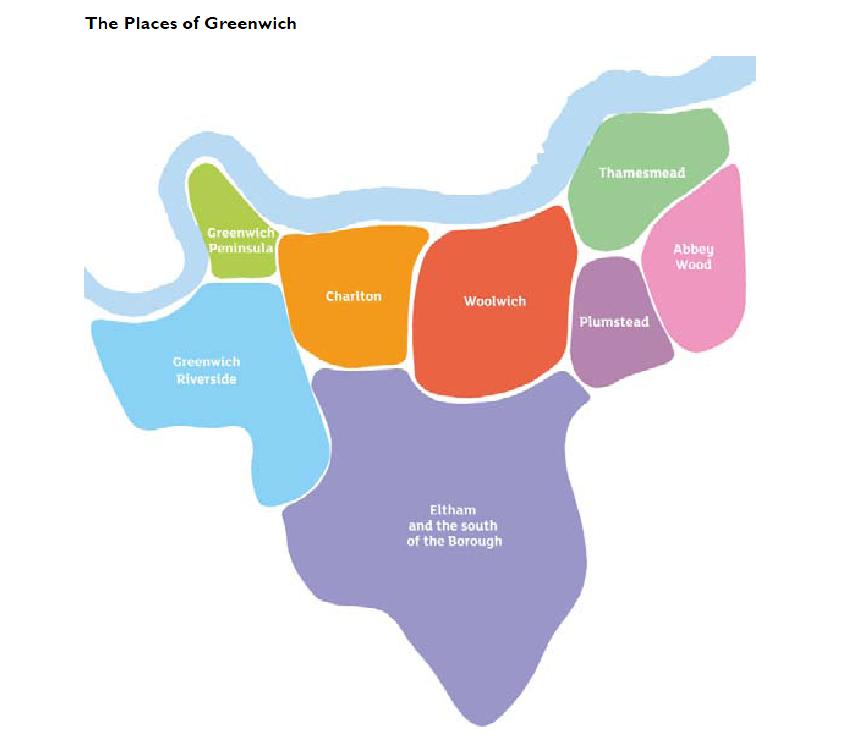
The Places of Greenwich according to the Core Strategy
Opportunities for art lovers to meet and talk to local artists in their studios start this weekend when some of the members of the Blackheath Art Society open their workplaces to the public. They are open from 12.00 noon to 6.00pm this Saturday and Sunday (27 & 28th April) and then again on the weekend of the 4th & 5th May. Admission is free.
The Blackheath Art Society leaflet, above, gives details of the artists and where they can be seen (click for a larger view). Some of the artists I saw last year are open again this year. I particularly enjoyed the creations of Nicola White, who makes her art from flotsam and jetsam found along the banks of the Thames such as lengths of driftwood and pieces of glass worn smooth by the tide. I must admit that the Thames Bottle Fish we got from Nicola last year is still waiting, with the wooden Roopachanda fish from Bangladesh, to be put up on the bathroom wall – it really needs a third fish to make a plaster duck like cascade. I also liked the acrylics, water colours and pastels of local scenes by Pat Colman, who teaches art at the University of the Third Age in Greenwich.
Blackheath Art Society also have a Taster Exhibition on at the moment until 19th May at the Greenwich Tourist Information Centre in Cutty Sark Gardens, and will hold their Summer Exhibition at the Blackheath Halls, Lee Road from 5th to 18th June.
There are so many artists working at the seven acre site of Second Floor Studios & Arts that I still haven’t got round them all, despite visiting on a couple of their open studios days. The next one opens on the evening of Friday17th May from 5pm – 9pm and is open on Saturday and Sunday 18th & 19th from 11am – 6pm. The range of creative work going on down by the Thames Barrier is enormous, as their web site says it includes:
SFSA have produced a Family Trail map and activity sheet to guide families with children on their exploration of the site and studios.
Also on the SFSA site over that weekend, the no format gallery has an exhibition of contemporary furniture and lighting produced by SFSA members, and the gallery will be the venue for the launch of Stephen Baycroft’s new book “On Sublimity and Synaesthesia”. And of course there’s the Thames-side Social Enterprise Arts Café CANTEEN to relax and recuperate in when you get studio-ed out.
We are not the only Shooters Hill in the world, though we may be the oldest. When researching local issues I’ve often come across other Shooters Hills, frequently finding that foreign namesakes have similarities to our own. Also our @shootershillbot, which scans twitter and elsewhere for mentions of Shooters Hill, often re-tweets information about other Shooters Hills that could be confused with local events.
There are extra Shooters Hills in the UK near Stoke on Trent in Staffordshire, at Pangbourne in Berkshire and in Cowes on the Isle of Wight. Overseas there are Shooters Hills in Jamaica and Australia, not to mention the site of the George Washington Masonic National Memorial in the USA.
Concerns here about the health effects of mobile phone masts are shared by residents of the Shooters Hill in Stafford, who have a long-standing campaign against the mast in their midst. They believe their Shooters Hill mast is the cause of seven deaths and twenty illnesses, as the Mail Online reported:
Since then there has been seven deaths and 20 illnesses, which locals claim is linked to the towering structure dominating the skyline.
Four people, including neighbours Elsie Jones, Yvonne Greensmith and Freda Oakes, have died from brain haemorrhages, all within three years of each other.
Three other residents have succumbed to cancer, among them John Cornes and John Butler, who died from a brain tumour.
Four non-fatal cases of cancer have been reported, as well as three people suffering irregular heartbeats, five who have constant headaches and sleeplessness and six who have high blood pressure.
Two have also complained that their epilepsy has worsened significantly in the last ten years. The three worst affected streets are Cherrywood Grove, Sandon Road and Milward Grove, which are all just yards from the mast.
Stoke-on-Trent City Council commissioned expert tests last year to find anything that would have a negative effect on human health but they found nothing.
The campaign against the Staffordshire Shooters Hill mast has been supported by local MP Robert Flello, who raised it in a parliamentary debate on the mobile telecommunications and health research programme in 2007, and local councillor Abi Brown. They haven’t (yet) succeeded in getting the mast removed, though they have prevented a second mast being erected.
The Shooters Hill in Pangbourne is a pretty road running alongside the Thames in Berkshire – a much narrower Thames there than the one we have views of. As well as the Thames connection to our Shooters Hill, it also has evidence of Roman occupation, “including many gold and silver coins and a number of skeletons”, according to the Royal Berkshire History web site, and was close to a Roman Road. There are three listed buildings on the Pangbourne Shooters Hill, two of which are part of a group of houses sometimes known as “The Seven Deadly Sins”. One of them, number 47, is in the same Queen Anne Revival style as the farmhouse at Woodlands Farm.
George Washington Masonic National Memorial by Joe Ravi (license CC-BY-SA 3.0)
The Pangbourne Shooters Hill also has a Masonic Hall, though it looks more modest than the 333ft high George Washington Masonic National Memorial on the top of Shooters Hill in Alexandria, Virginia, near Washington, D.C. There is a debate about how the masonic Shooters Hill got its name which is very similar to the different ideas about the etymology of our own Shooters Hill, as the DC Pages web site says:
Some claim that it derives its name from the fact that it was once home to two forts during the Civil War era. From this vantage point, Union soldiers or “Shooters” could protect the approaches to Alexandria and Washington, DC against the possible attacking Confederate forces. Others claim that the hill was originally called “Shuter’s Hill, after an early resident of Alexandria.
Shooter’s Hill is named for the Shooter’s Hill area of South London. The Smith family, which owned Shooter’s Hill, came from the Shooter’s Hill area of London and claim descent from the explorer Captain John Smith. See: Smedes, p. 12; “Smith, William Morgan, M.D.”, p. 555-556. However, some archeologists believe the name was derived from the last name of an inhabitant in the 1740s. See: Allen, Mike. “City’s Hill Holds 5,000 Years of History.” Washington Post. May 22, 1997.
The Australian and Jamaican Shooters Hills sometimes turn up in tweets that may be confused with local events, for example traffic problems in the Jamaican Shooters Hill and snow reports in the New South Wales one. Shooters Hill in Australia must be the highest: at 1355m it’s over ten times the 129m height of our hill. Shooters Hill in Jamaica is renowned for being the home of Pickapeppa Sauce, sometimes described as “Jamaican ketchup”. It is also the site of Captain Heron’s tomb.
Finally, an addition to the Ghosts of Shooters Hill, though this time in a Shooters Hill in Cowes on the Isle of Wight. This tiny, touristy street is shown on Ghost Island‘s spooky ghost map of Cowes, because it is haunted:
A little ghost named Ursula haunts properties in Shooters Hill. At one, the spirit of a young girl with straight blonde hair was often seen by the owners who even bought a Ouija board to find out why she was haunting them. Lala, as she likes to be called, wears a black Victorian dress, a long white pinafore trimmed in broderie anglais and little black boots. Lala is aware she has died, but doesn’t want to ‘move on’.
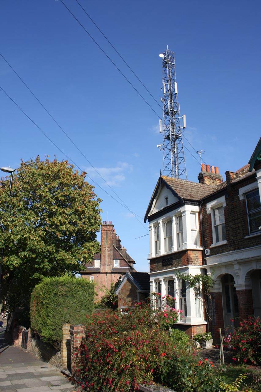
Shooters Hill Fire Station Mast from Eaglesfield Road
Will the new 4G mobile phone system interfere with our Freeview TV reception? We may find out next week when a test is being run in south-east London, including parts of Greenwich. A company called at800, a brand name for Digital Mobile Spectrum Limited (DMSL), is running the tests. Their press release said:
A test to help understand the extent to which 4G at 800 MHz may disrupt Freeview is being run in south east London. at800 is asking viewers in the area to report problems with television reception from Monday 15 April. at800 is the organisation tasked with ensuring viewers continue to receive Freeview when 4G mobile services at 800 MHz are launched later this year.
Approximately 170,000 household and business addresses in parts of Greenwich, Lewisham, Southwark and Tower Hamlets are being contacted directly to alert them to the test. This larger-scale testing follows an initial small-scale test in the West Midlands.
Households that at800 think will be affected will be sent a postcard like the one below in the next few days.
at800 specimen postcard
The new 4G mobile broadband will use the 800MHz frequency band that used to be used for analogue TV. This is close to the 700MHz that Freeview uses. An article by Barry Fox in April’s edition of Everyday Practical Electronics explained:
The 800MHz 4G band is very close to the 700MHz band frequencies used by Freeview. Co-channel interference is inevitable, especially for homes close to a 4G base station and where aerial amplifiers are used. Interference may well be variable and intermittent, making it harder to tie cause to effect.
It was estimated by Ofcom that that the problem could affect up to 2.3million homes, but in an initial pilot study covering 22,000 homes in the Midlands only 15 homes suffered interference.
If you suffer TV interference next week, at800 have a number for you to call:
If you live in the south east London area and notice problems with your Freeview service from 15 April, please contact at800 by calling 0333 31 31 800. You will be asked for your postcode, the type of interference and the time it occurred. This will allow at800 to restore your service as soon as possible. Freeview is the television that viewers receive through their aerial.
Most cases of interference can be solved by fitting a filter between the TV and aerial, and at800 will provide one filter to each affected household. The at800 website has details of what needs to be done in different situations, and of the support that will be provided. In the worst case, where a filter doesn’t solve the problem then at800 will provide an alternative such as Freesat or cable at a cost of up to £10,000.
Cable and Satellite TV will not be affected by the 4G signal, only over the air, digital terrestrial television, to aerials.
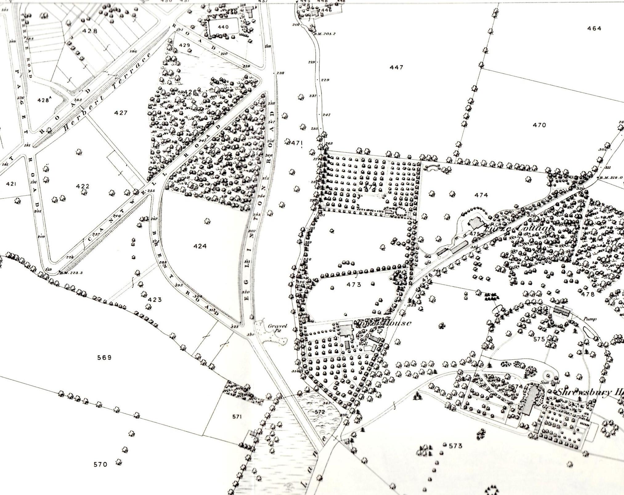
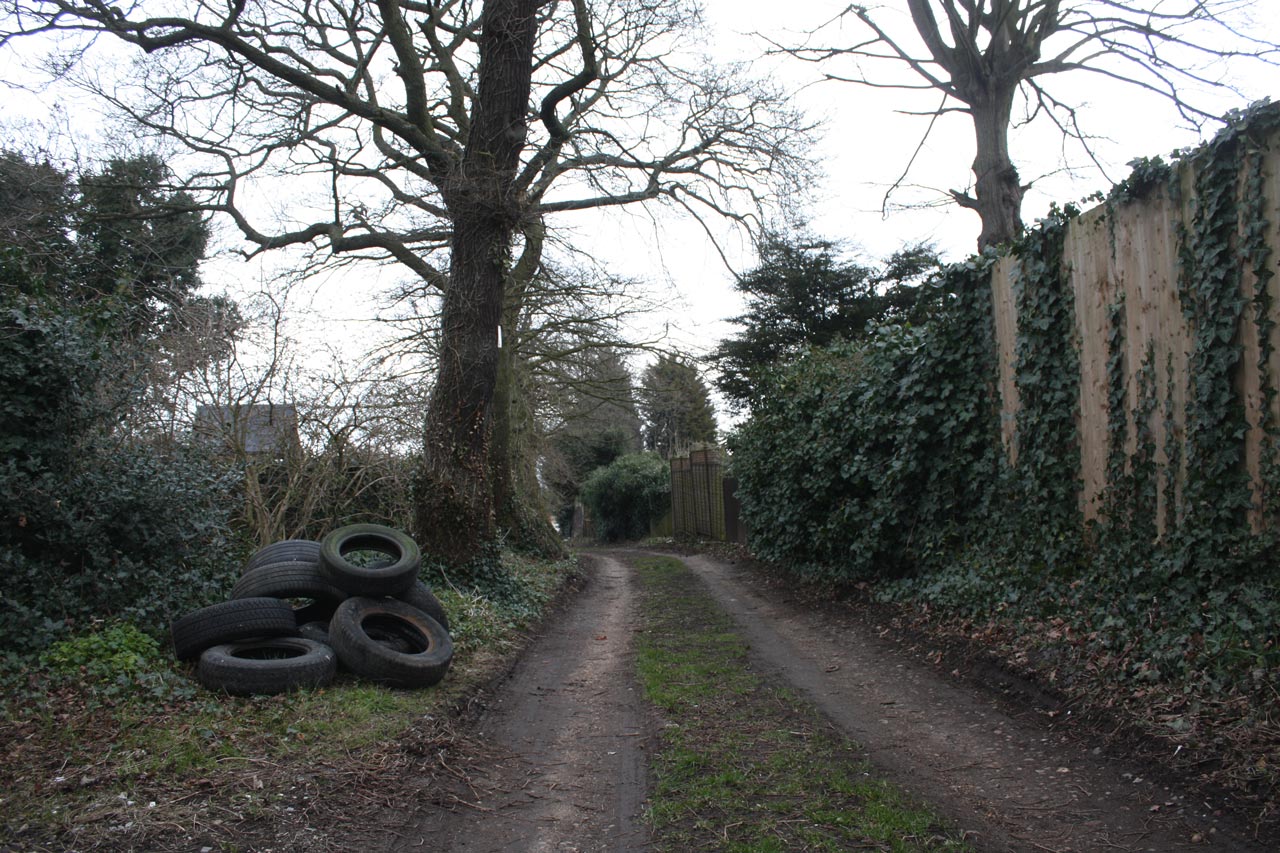
Mayplace Lane may at first sight seem like a typical back alleyway running to the garages behind houses in Eglinton Hill, but it’s much more than that. As you can see in the snippet from Alan Godfrey‘s 1866 OS Map of Shooters Hill it was there before the houses in Eglinton Hill were built, winding down behind Tower House parallelling Eglinton Hill. The Lane is thought to be part of a track that went all the way down to the Woolwich Marshes, following the line of Sandy Hill Road. According to the Survey of London Volume 48 on Woolwich, Sandy Hill Road itself “was laid out along the line of a footpath that rose diagonally through what had been called Hilly Field”. So it seems that before the roads we now know were laid out Mayplace Lane ran from the Bronze Age barrow in Plum Lane all the way to the marshes that once bordered the Thames.
Mayplace Lane with Fly-tipped Tyres
Mayplace Lane is also, in places, a pretty and secluded path, providing a pleasant alternative route down the hill towards Woolwich, though it is a bit uneven in places especially around High View flats where it shares the hill with a permanent water flow of what appears to be spring. Well it would be pretty if it weren’t for the persistent fly tipping which has blighted the lane for years. This isn’t just the usual dumped mattresses, but lorry-loads of old tyres, building remains and, at the moment what looks like corrugated asbestos roofing sheets.,
In the past the Royal Borough of Greenwich Clean Sweep team have removed fly-tipped rubbish, though they maintain that they don’t have to because Mayplace Lane is an unadopted road. Frustratingly the current piles of rubbish have been there for some time and consequently are being scattered over a wider area. A twitter exchange about the rubbish last week has led to e-mails being sent to our local councillors, MP Clive Efford and London Assembly Member Darren Johnson to try to get some action.
One suggestion, which I thought was a good idea, from @Twinsclubplus was that we should have a “Friends of Mayplace Lane”, which I guess would be a bit like the “Friends” groups that look after local parks. It could keep an eye out for fly-tippers, make sure any tipping was reported promptly, perhaps help clear up the Lane and lobby towards getting a more permanent solution to the problem such as a lockable gate up at the Plum Lane end.
Please let me know if you’re interested in being involved with a “Friends of Mayplace Lane” group on the usual e-mail hilly@e-shootershill.co.uk.
Of course fly tipping is not confined to Mayplace Lane: it’s a borough-wide problem which has been going on for years. In the past the local neighbourhood watch and the 853 blog have both explained what to do about it, but here’s a reminder.
Make a note of as much information about the fly-tipped waste as possible, in particular:
Where it is, with the post code if you know it
How much waste there is, from a single item up to multiple lorry loads
What type of waste it is, for example demolition waste, tyres, asbestos …
The type of land it is on, such as a public highway, back alley, private land …
If possible make a note of any information about the fly-tipping incident:
Date and time.
Nearest road junction
Identification of who did it such as a description, car registration number etc
Report it either by:
Phone 020 8921 4661 during office hours (Monday to Friday 8am to 8pm, Saturday and Sunday 8am to 1pm)
We will remove all small flytips (equivalent to a small van load) within 24 hours and, if possible, take action against those responsible.
Large flytips, classified as anything larger than a small van load, will be dealt with by contractors within four working days on a priority basis.
Any items that have been fly tipped at the side of the road will be collected and separated for recycling. Our teams will endeavour to stop and collect any fly tips they find, unless it would prevent them from completing their scheduled or booked work in which case they will report it so a dedicated team will remove the fly tip.
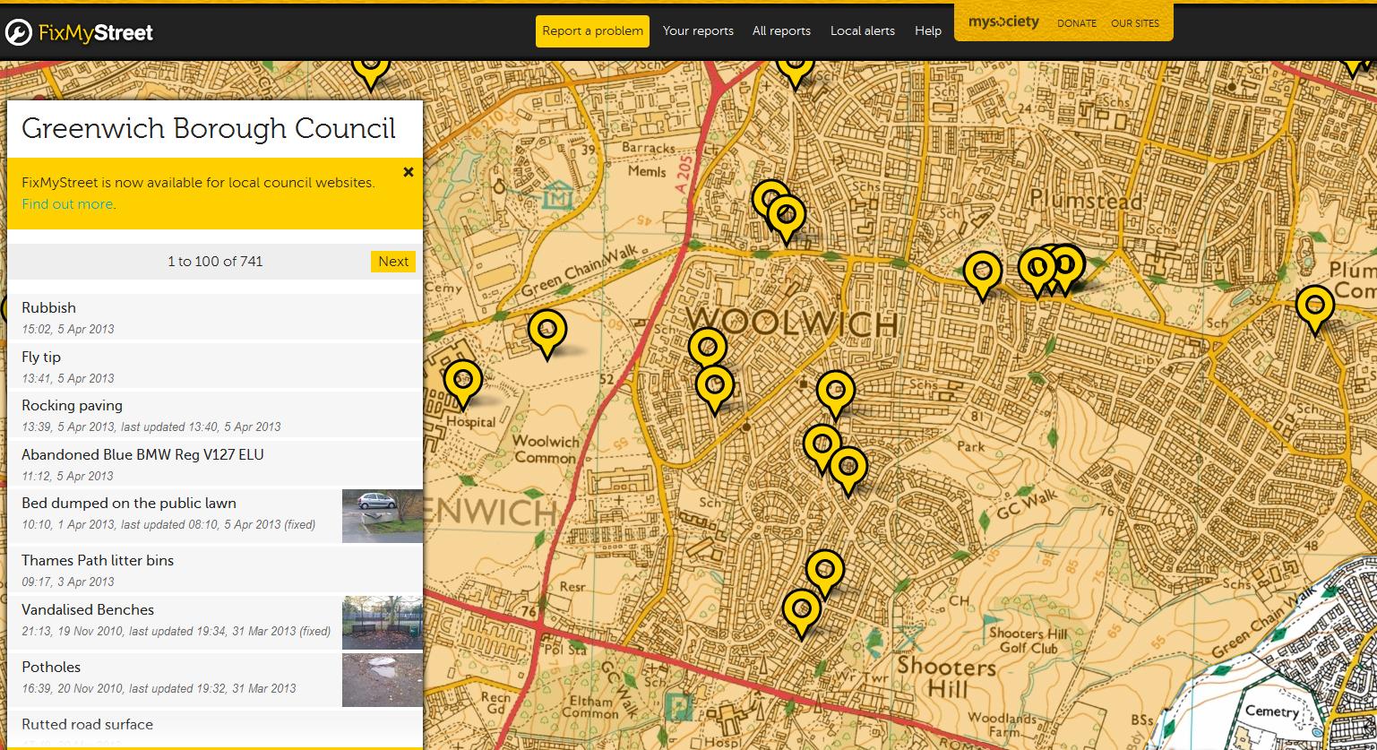
Another way of reporting fly tipping, and other problems, is to use the FixMyStreet web site, which will then forward the report to the council. This can be done either by entering a post code or interactively using their map. It allows you to attach photographs of the problem too. On FixMyStreet you can easily see all the problems reported in your area, as shown in the screen grab below.
Snippet from FixMyStreet web site
I wonder how long Mayplace Lane has been there? It’s intriguing that it runs from the Plum Lane Bronze Age Barrow, one of what was once a barrow cemetery of 6 barrows, down to the Woolwich Marshes. Recent archaeological finds at the Plumstead Crossrail site have suggested that Bronze Age people may have built wooden causeways across the Plumstead Marshes similar to those that spanned the marshlands of the Somerset levels. Bronze Age remains have also been found just over the river in North Woolwich. During the Bronze Age it is believed that people distinguished between the land that they lived in and farmed – the land of the living- and the land of the ancestors where their burials took place. Could Mayplace Lane have been their route from their villages around the Woolwich and Plumstead marshes up to the sacred Shooters Hill summit, the land of their ancestors?
I notice the Royal Borough of Greenwich has re-vamped the planning applications search facility, which may explain why my regular PlanningFinder e-mails have been a bit brief recently, and why links to planning documents in old e-shootershill posts no longer work. A quick browse through recent applications in the Shooters Hill ward revealed some interesting applications.
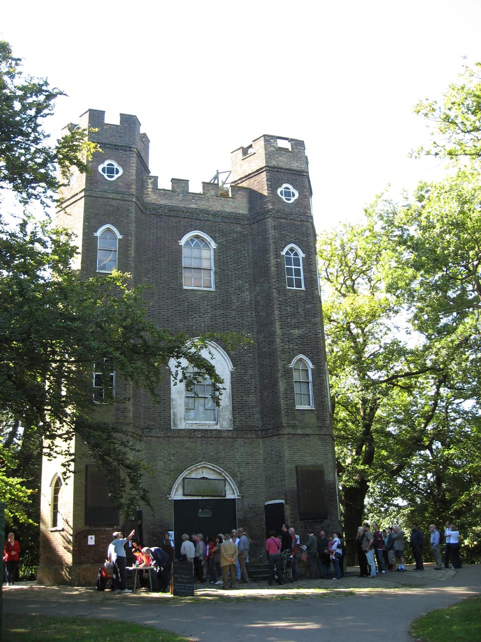
Severndroog Castle Building Preservation Trust have applications for planning and listed building consent for their long-awaited programme of repairs and alterations to the castle which are part funded by the Heritage Lottery Fund. The summary for applications 13/0228/F and 13/0229/L on the planning page is:
Repairs and alterations including new external steps and landing, new 2 metre high perimeter security fence and gates, infilling of two external door openings, new sliding glazed doors to main entrance, new kitchen and toilet facilities, replacement of lead roofing and timber viewing platform, new electricity supply cubicle. Installation of new and replacement mechanical, electrical and telephone services in connection with the above.
I believe the work is as described in their 2010 applications 10/0346/F and 10/0136/L. There will be a café on the ground floor, a space for functions on the first floor and an education space on the second floor. There will also be access to the viewing platform at the top, which has great views over London (and a video feed for those unable to climb to the top). The documents submitted with planning applications are often a great source of historical information. In this case the 10/0346/F Conservation Management Plan provides an excellent summary of the history of Severndroog Castle, complete with maps and copies of paintings, engravings and photographs of the castle from the early 19th century onwards.
I’m looking forward to the re-opening of the castle and another chance to enjoy the view over the city from a platform that is 46 feet above the cross on St Paul’s Cathedral.
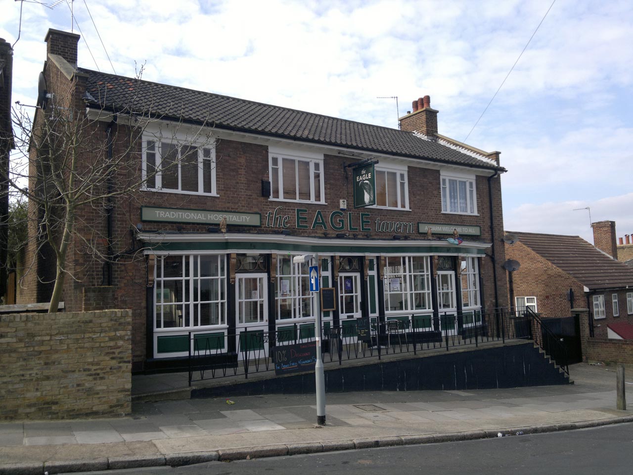
The Eagle
Further down the hill in Red Lion Lane it is proposed in application 13/0186/F to convert the former Eagle Tavern into 5 flats:
Conversion of existing Public House into 5 flats consisting of 1 x 3-bed, 2 x 2-bed and 2 x 1-bed self contained flats. | THE EAGLE TAVERN, 78 RED LION LANE, PLUMSTEAD, LONDON, SE18 4LE
The application says that the “street scene will not alter ” as a result of the conversion. The frontage of the pub will be retained, but a light-well will be excavated at the front of the building to allow windows for the basement flats. The style of these windows will be carried down from the feature windows of the pub. There will also be a pair of light-wells at the back of the building.
Yet another pub lost. Any comments about the application need to be in by 09/04/2013.
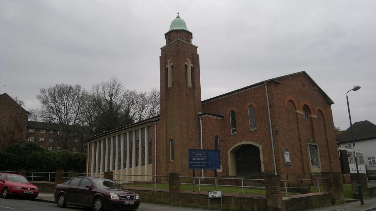
All Saints Church
Another planning application, 13/0495/F, proposes major changes at All Saints Church on Herbert Road:
Demolition of existing parish hall, erection of a new parish/community hall and vicarage, parking and associated works, remodelling of church entrance to provide level entry.(Reconsultation). | ALL SAINTS CHURCH, HERBERT ROAD, WOOLWICH, LONDON, SE18 3QH
The idea is to replace the old church hall that is to the right of the church with a new 4-bedroom vicarage and to build a new church hall on the Ripon Road facing grassed area to the left of the church, which the agents acting for the church describe as “surplus land”. The new church hall would be single storey, sedum-roofed and connected with the rear of the church. The Church wish to replace the old timber-framed prefabricated church hall because it is in extremely poor condition, uneconomical to repair, has poor accessibility and is inadequate to the community’s needs. They also feel the old vicarage is unsuitable because it is too large to economically heat and furnish and it doesn’t allow separation of the public and private aspects of the incumbent’s life.
The development is to be funded by selling the vicarage, over the road at 106 Herbert Road and, more controversially, building two 3-bedroom terraced houses, a 2-bedroomed flat and a 1-bedroomed flat on the back garden of the vicarage in Ripon Road. Sounds to me like a bit of garden grabbing. The covering letter for the application says:
These proposals are directly linked to our clients’ residential proposals on land adjoining no. 30 Ripon Road. A planning application seeking outline consent for the erection of 2×3 bed terraced units, 1×2 bed and 1×1 bed flats is submitted simultaneously with this application. From the details accompanying both applications it will be noted that the two developments are closely linked and for this reason it is requested that both proposals are determined together.
I couldn’t find the second planning application on the Royal Greenwich web site, and it is not clear whether it is still possible to comment on either application – the comments tab for application 13/0495/F says that “Comments may not be submitted at this time”. Together these applications would be a significant change to that small area.
Update: A notice on the lamp post near the church in Ripon Road says that comments should be sent to the council before 16th April 2013.
I guess the Royal Borough of Greenwich planning page changes are still bedding in. They didn’t allow me to register to make comments – giving the message “Unable to complete your registration – Unable to send confirmation e-mails at this time. Please try again later.”