Ye who have a spark in your veins of cockney spirit, smile or mourn acccording as you take things well or ill;— Bold Britons, we are now on Shooter's Hill!
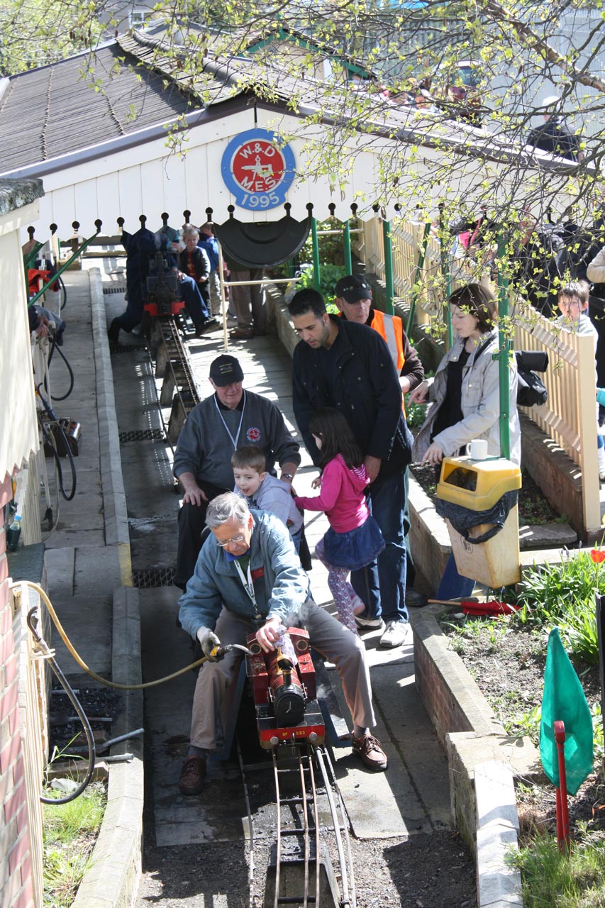
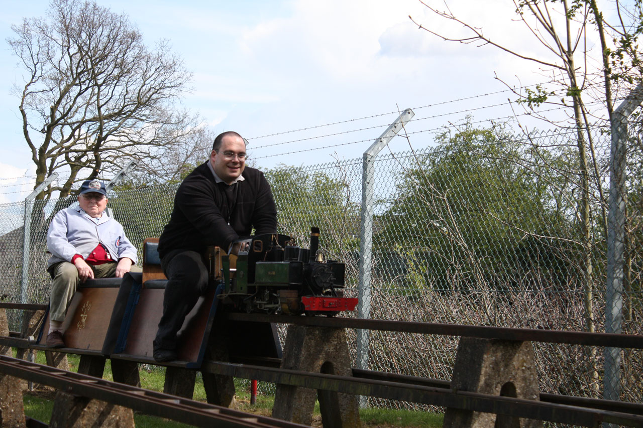
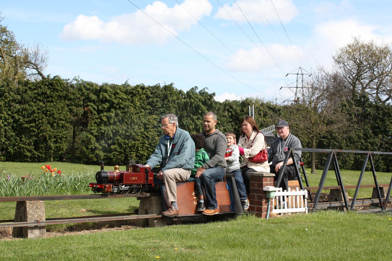
Welling and District Model Engineering Society public running
The Falconwood Model Railway has finally been told to move from its current site on Rochester Way, and will be homeless from the end of this year unless another site can be found.
The Welling and District Model Engineering Society recently posted the announcement on its website:
National Grid is building a cable tunnel from Bexley to Woolwich to cope with increased electricity demands in London. This project was first proposed in 2008, at which time we were warned that our miniature railway site, at Falconwood, would be required for one of the Tunnel Head-houses and that, consequently, we would have to relocate. The project was then put “on hold” and we were given various dates when the project was likely to restart – all of which passed with no activity.
We have now been told that the site will definitely be required by National Grid in early 2019.
We do not have a definite date when we will need to be off the site, but it is very likely that no Public Running Days or Parties will be held in 2019. National Grid has, however, guaranteed that we can complete our 2018 season of planned events, including the Santa Special in December.
Meanwhile, we are negotiating with National Grid and local Councils to identify assistance with relocation and suitable sites to which we can move the Welling and District Model Engineering Society facilities and its Miniature Railway.
A number of persons who come to our Public Events have suggested that a petition be raised. We thank them all for their thoughts, but a petition would be unlikely to change the tunnel plans and might adversely affect our relocation negotiations.
As soon as we have any updated information, we will post it on this site and notices will be posted at our Miniature Railway at remaining Public events this year. In addition, we have set up an email address if you have any questions about W&DMES activities, or the relocation progress.
If you have any suggestions about suitable sites to which we could relocate, or can offer any form of assistance with the move, please contact us using the email address or speak to one of the members at the Miniature Railway.
The society has been running since 1945 and has given pleasure to generations of children (and adults). Let’s hope they can continue in a new home.
Welling and District Model Engineering Society public runningWelling and District Model Engineering Society public running
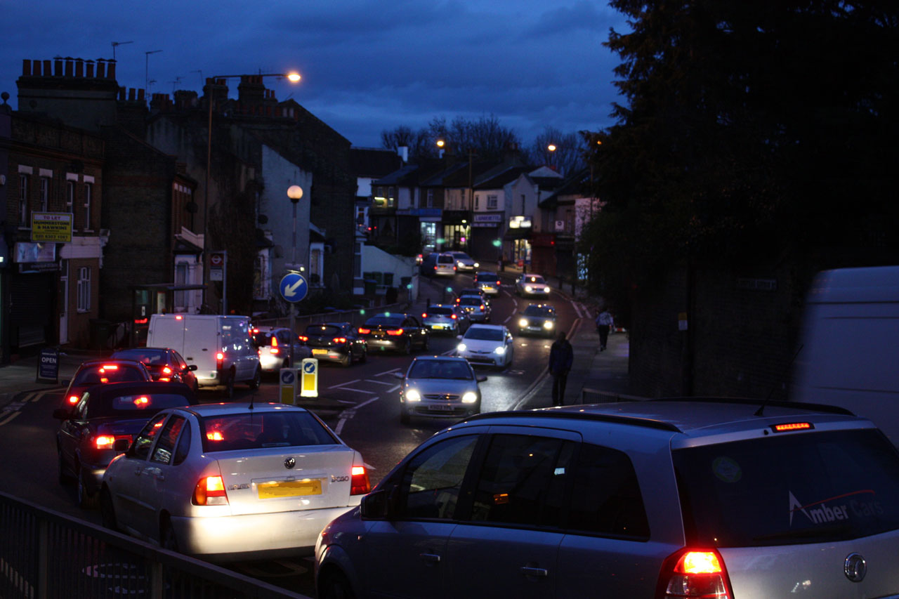
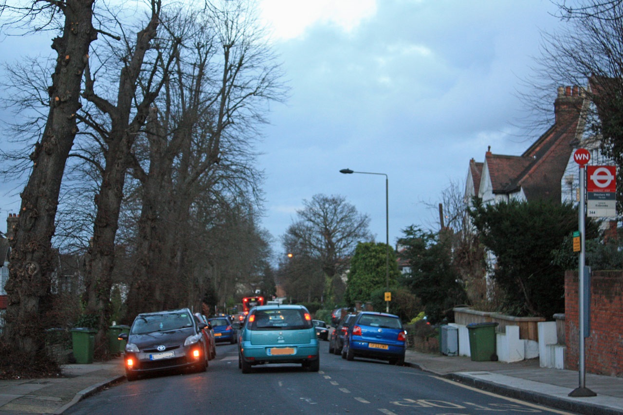
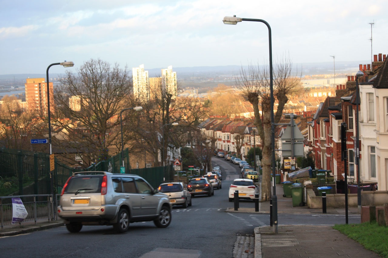
Evening rush-hour traffic on Plumstead Common Road
There are just a few days left to tell TfL our opinions about their proposed new river crossings at Gallions Reach and Belvedere: the consultation closes this Friday, 12th February. We can respond through an online survey with just 5 questions at:
We can also tell TfL what we think by email to rivercrossings@tfl.gov.uk or by writing to FREEPOST TfL CONSULTATIONS’.
It’s an opportunity to tell Transport for London of our concerns about the increased traffic congestion in our area that their own traffic models predict will come as a result of the new crossings: congestion that will lead to even more dangerous air pollution and the health problems that it causes. The excellent Bexley Against Road Crossings web site has many more suggestions about what to say to TfL.
No to Silvertown Tunnel pollution study results from 2014
The NO2 results map shows that the UK Air Quality Strategy and EU legislation 40 µg m³ limit for NO2 was exceeded at most measurement locations in Shooters Hill and Plumstead: at two sites along Plumstead Common Road and all sites along Shooters Hill and Shooters Hill Road. The cross roads at Shooters Hill Road and Academy Road, close to the Greenwich Free School and just down the hill from Christchurch Primary School had an NO2 level 162.5% of the limit. A similar level was detected down in Woolwich at the junction of John Wilson Street and Wellington Street, close to Mulgrave Primary School. The level near Greenslade Primary was only just below the limit. Children are particularly vulnerable to the health effects of NO2 from traffic pollution.
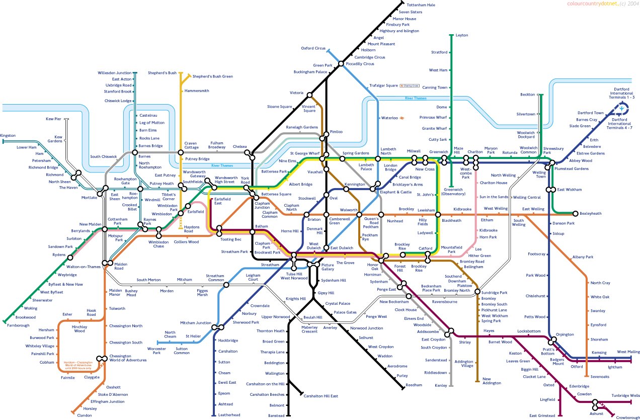
Upside Down Tube Map – with North/South reversal from not Geofftech.co.uk
I’ve never really understood TfL’s argument justifying new crossings by the fact that there are many more road crossings to the west of tower bridge than to the east. It seems obvious to me that you would have fewer bridges closer to the sea because the river gets wider at it nears its estuary. A better comparison might be the difference in public transport, such as the tube, between north-west and south-east London. This is illustrated by the tube map variation from Geofftech, shown above, which reflects the tube map across to the south-east. If we were as well served as the other side of London we would have tube stations at the Rotunda, Woolwich Common, Shrewsbury Park and Plumstead Gardens, and the tube network would stretch as far as Tunbridge Wells.
TfL would have far more chance of reducing traffic congestion and pollution by improving our current very unreliable and overcrowded public transport and creating new public transport links than by building more roads which will attract more traffic. It’s well worth reading former Greenwich councillor Alex Grant’s very informative post: The supporters of new roads across the Thames are stuck in the past. Without rail links they’d be a disaster for east London for more on the history of east London river crossings, how other modern European cities have tackled the problem of congestion and the recurrent fears that a motorway will be built through Plumstead, Woodlands Farm and Oxleas Wood.
Transport for London seem determined to push ahead with their planned crossings: a recent e-mail from them said:
Last week Transport for London’s Board gave approval for us to submit a Development Consent Order to the Secretary of State for Transport for powers to implement the Silvertown Tunnel scheme. Our application will include a Consultation Report, which will set out our response to all of the issues raised in our recent consultation. We received more than 4,000 responses to the consultation and these are continuing to help inform our final plans.
We plan to submit an application for powers to implement the Silvertown Tunnel scheme in the spring 2016, and we will contact you again at this time once we are in a position to publish our Consultation Report.
If our application is accepted by the Secretary of State, there will be a public examination on the scheme managed by the Planning Inspectorate. In that case, you will have an opportunity to make written representations and take part in hearings as part of the examination. We will explain how you can take part in the examination when we write again, later this spring.
If you’re concerned about how these new crossings will affect traffic congestion and pollution in south-east London then you might like to attend the No to Silvertown Tunnel campaign’s annual general meeting which is at Mycenae House, Blackheath, on Thursday 18 February at 8pm. They ask that anyone planning to attend sign up at https://www.eventbrite.co.uk/e/no-to-silvertown-tunnel-agm-2016-tickets-21083026901
Oh, and complete the TfL East of Silvertown consultation before Friday.
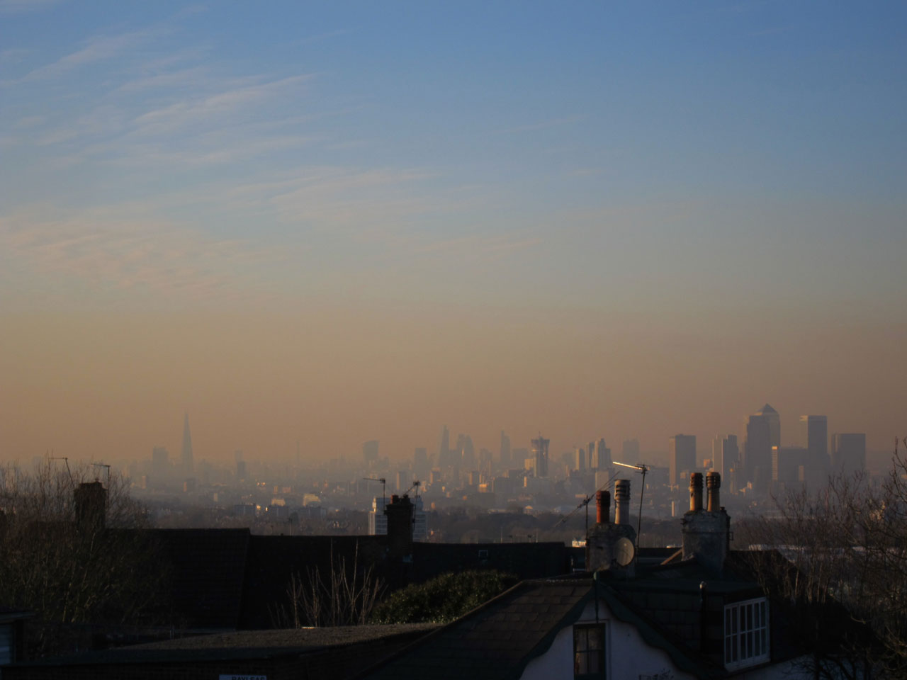
Orange fug over London at time of high air pollution
How will the proposed new East London river crossings affect traffic in Shooters Hill? This was the question I looked for answers to in the documentation accompanying Transport for London’s latest consultation on the crossings. As TfL have previously accepted that the road infrastructure south of the Thames is not adequate to serve the proposed new crossings this seems to be an essential question for them to answer.
The documentation includes a Traffic Impact Report: great, I thought, that’s where I’ll find the answer, but no, it turned out to be far more complicated to find what I was looking for.
The first complication is that the report assumes that the proposed Silvertown Tunnel has already been built. It doesn’t explicitly say so: it models the traffic effect of the new crossings compared with a Reference Case, which “reflects the highway network in 2031”. Reading through it quickly becomes clear that the traffic flow changes calculated are the effect of adding the Gallions and Belvedere crossings to a road system which includes the Silvertown Tunnel. Not the change from today’s traffic flows to those after the proposed crossings are developed.
No problem: there was a Silvertown Tunnel consultation recently, which included amongst its archive documents a Traffic Forecasting Report from 2014. This should let me see the changes to traffic as a consequence of the Silvertown Tunnel, I thought, which I can combine with the latest report to see what the total impact of all the proposed new crossings will be.
But again no. The Silvertown report also assumes a reference case which is the traffic in 2021. Why? They don’t seem to say. This reference case is defined as:
Reference case (2021)
6. The reference case represents 2021, and includes growth in population and employment from the 2009 London Plan. Population is expected to increase more rapidly in east and south east London than in other sub-regions.
7. The reference case also includes committed transport schemes. Public transport connectivity across east and southeast London improves because of planned investment including Crossrail. The Woolwich Ferry is assumed to have been enhanced with 30% additional capacity. The reference case does not include the Silvertown Tunnel.
8. From 2012 to 2021 the proportion of travel by car is expected to fall in Greenwich, Newham and Tower Hamlets, but the growth in population and employment result in an increase in total car trips.
Why they think the Woolwich Ferry will have 30% more capacity is also unclear – a footnote in the report just says that “by 2031 Woolwich Ferry would need to either be upgraded at its existing location or replaced with a new crossing”. This upgrade is not a “committed transport scheme” as implied by the extract above. They also assume that the Woolwich Free Ferry will be charged, as would the Blackwall, Silvertown, Gallions Reach and Belvedere Crossings. The charges would be the same as for the Dartford Tunnel at peak times and half that rate at other times. TfL assert that these charges will counteract the “induced traffic effect” where new roads generate new traffic. However their rationale for this assertion is unconvincing and they say it “… is not modelled in the Assessed Case.”
The Silvertown Traffic Forecasting Report also considers in Appendix C the impact of the Gallions and Belvedere crossings on traffic flows. Interestingly it ends up with different results to those presented in the Gallions/Belvedere consultation Traffic Impact Report.
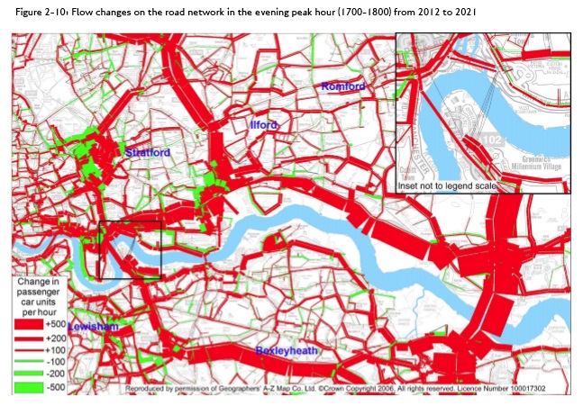
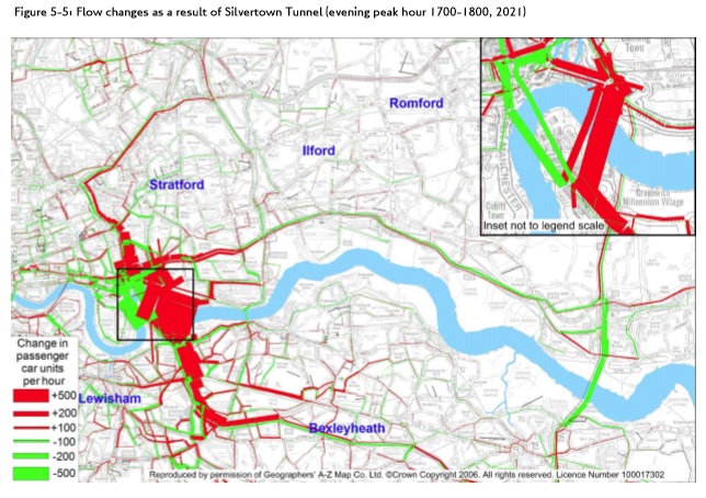
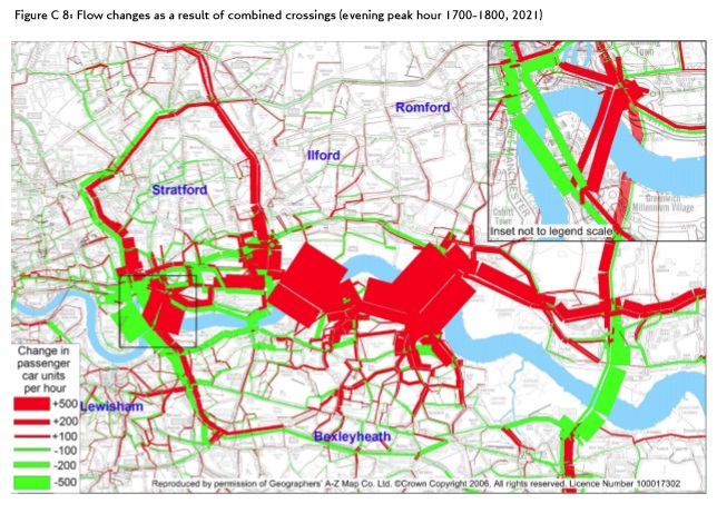
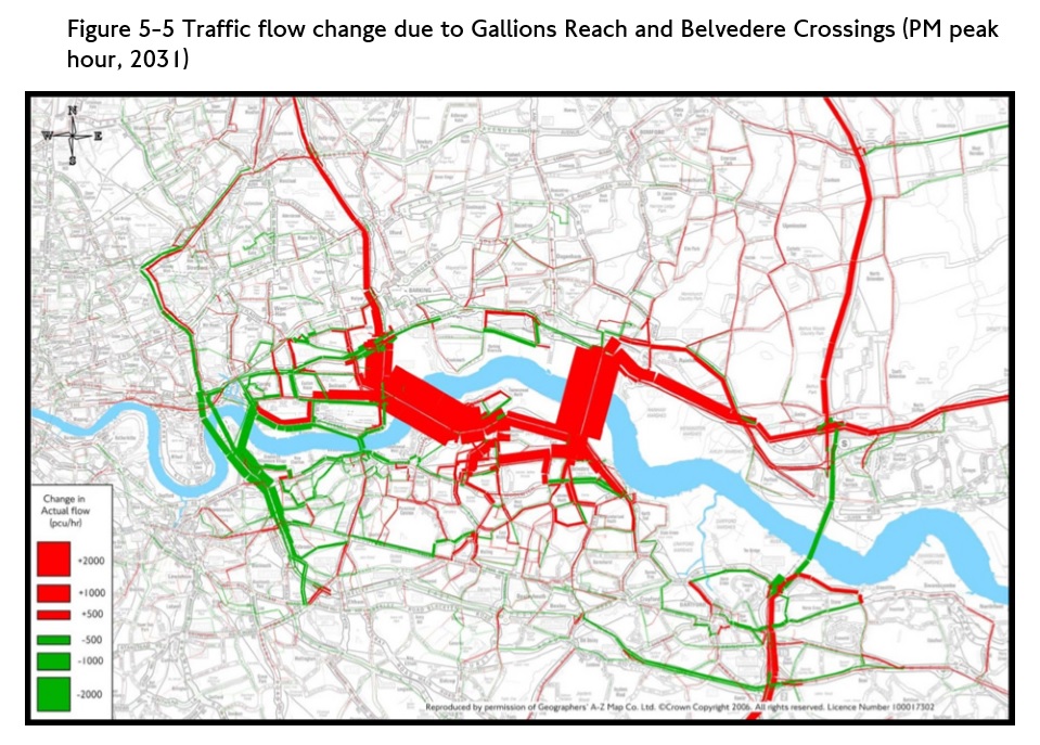
The reports contain a large number of tables, graphs and maps of the traffic modelling results. I’ve extracted four maps to try to give a flavour of the impact of the crossings on our local streets. All four are for the afternoon rush hour traffic:
The 2021 “Reference Case” from the Silvertown Tunnel Report;
The impact of the Silvertown Tunnel compared to the reference case from the Silvertown Tunnel Report;
The impact of the Gallions Reach and Belvedere crossings compared to the reference case and Silvertown Tunel from the Silvertown Tunnel Report;
The impact of the Gallions Reach and Belvedere crossings compared to the reference case from the Gallions/Belvedere Report.
Red on these maps indicates increased traffic flows and green reduced.
Reference case afternoon peak traffic flow increases from Silvertown Tunnel Traffic Impact ReportPost-Silvertown Tunnel afternoon peak traffic flow increases from Silvertown Tunnel Traffic Impact ReportPost-Silvertown Tunnel and East London crossings afternoon peak traffic flow increases from Silvertown Tunnel Traffic Impact ReportAfternoon peak traffic flow increases from Gallions Reach and Belvedere Traffic Impact Report
The scale and resolution of the maps make it difficult to work out which local roads suffer traffic increases, but it’s just about possible by zooming in and looking at the shape and orientation of the roads. The red/green bar method of showing traffic changes also tends to obscure rather than illuminate. Anyway, here’s my interpretation of what the modelling is showing.
The reference case, which just reflects population growth and an increase in Woolwich Ferry capacity, already has big increases – 100 cars per hour or more – along Shooters Hill Road, Shrewsbury Lane, Plum Lane and slightly surprisingly Donaldson Road too. The increase along Plumstead Common Road looks even bigger, and also along Kings Highway, Wickham Lane down towards Knee Hill.
Bringing the Silvertown Tunnel into the model there is a decrease in traffic flow along Shrewsbury Lane and Plum Lane, but an increase in Red Lion Lane which runs in a similar direction. Along Shooters Hill and Shooters Hill Road traffic flows increase again, and the route down through Charlton to the tunnel has more traffic, affecting Baker Road and Stadium Road past the hospital then Charlton Park Lane and Cemetery Lane.
In the Silvertown Tunnel report the impact of the additional crossings at Gallions Reach and Belvedere is a very slight reduction of traffic along Shrewsbury Lane, but an increase along Eaglesfield Road to Plum Lane which is unexpected (and unlikely I would have thought), and an increase in Plum Lane itself. Not unexpected are the additional increases in Plumstead Common Road and the route down to the High Street via Griffin Road, nor those from Plumstead Common down Kings Highway to Wickham Lane and Basildon Road and Eynsham Drive. There is lots of red showing big increases from the A2 over towards Gallions Reach and Belvedere, affecting Upper Wickham Lane, Lodge Hill, Okehampton Crescent, Brampton Road and Knee Hill (yet again).
It also predicts that traffic going along the bottom of Herbert Road, through the shops will increase. Can you imagine even more cars trying to negotiate the hazardous route between parked vans and oncoming buses in the rush hour?
The final map, from the current consultation, is similar to the previous one but now there is an increase in traffic along both Shrewsbury Lane and Eaglesfield Road. Other flows appear to be increasing less than in the Silvertown report. In the Gallions Reach/Belvedere report TfL admit to using an earlier version of the traffic model than in the Silvertown report, but don’t really explain why.
The striking feature of all of these maps is the amount of red on them, showing cumulative increases in traffic flows as each crossing is built.
The traffic modelling doesn’t seem to take account of how the roads actually are. For example, that nice straight red line showing increased traffic from Shooters Hill along Shrewsbury Lane and Plum Lane through to Plumstead Common Road. These are residential roads, not suitable to be used as a through route, with speed bumps, and a 20mph limit along Plum Lane. Very often the traffic is single file due to parking on either side of the road. Plum Lane passes close by Plumcroft Primary School. And at the bottom there’s that narrow one way stretch of Plum Lane, making traffic going down the hill turn left and then right along Kirk Lane to get through to Plumstead Common Road. The very sharp turning between Plum Lane and Plumstead Common Road doesn’t exist as far as TfL are concerned.
Similar points could be made about many of the other roads showing increased congestion on TfL’s maps. There are campaigns in Plumstead and Bexley to oppose the crossings, largely because of the devastating impacts on local residential roads.
The main effect of breathing in raised levels of nitrogen dioxide is the increased likelihood of respiratory problems. Nitrogen dioxide inflames the lining of the lungs, and it can reduce immunity to lung infections. This can cause problems such as wheezing, coughing, colds, flu and bronchitis.
Increased levels of nitrogen dioxide can have significant impacts on people with asthma because it can cause more frequent and more intense attacks. Children with asthma and older people with heart disease are most at risk.
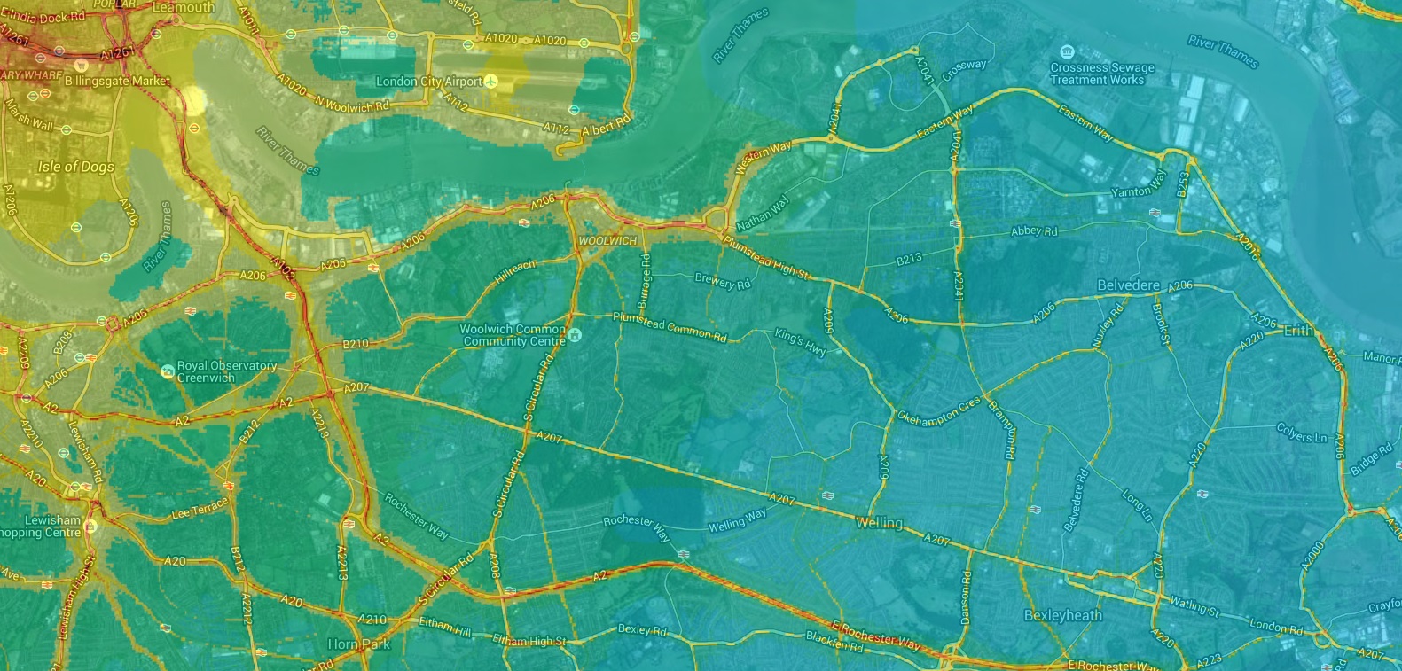
The UK Air Quality Strategy and EU legislation both set an annual average limit for NO2 of 40 µg m-³. In London in 2013 only two local authorities met the limit for NO2, and Greenwich wasn’t one of them. Kings College’s London Air web site has mapped 2010 NO2 levels across London: I’ve included a snippet showing Shooters Hill below. The 40 µg m-³ is shown in yellow on the map, with higher concentrations in deeper shades of orange and red. As well as the major roads, there are high levels along Shrewsbury Lane and down Eglinton Hill, Sandy Hill Road, Burrage Road, Plumstead Common Road and Swingate Lane.
Modelled annual mean NO2 air pollution, based on measurements made during 2010 from London Air web site
We have until Friday 12th February to respond to this latest consultation. The main themes of this consultation are whether it would be better to build a bridge or dig a tunnel at the two locations, and about how public transport might link to them. We can respond through an online survey, by email to rivercrossings@tfl.gov.uk or by writing to FREEPOST TfL CONSULTATIONS’.
As I’ve said before in posts about a previous consultation and about Oxleas Wood TfL need to say how they will solve the inadequacies of the transport network south of the Thames and demonstrate that new crossings will not cause congestion and pollution in residential roads. Otherwise people will think that they are cynically conspiring to cause chaos and compromise air quality in south-east London so as to be able to justify a new motorway from the A2 to the river through Oxleas Wood, Woodlands Farm and hundreds of Plumstead homes.
“Back to London for Lot 220, Land adjoining Furze Lodge, Plumstead SE18″, the auctioneer said, “Lot of interest, someone on the phone, couple on the internet. Shall we start at £30,000?” The bidding quickly progressed to £60,000 in £5,000 steps when it was sold to a phone bidder.
I was watching the final stages of Allsop’s residential auction over the internet at home. I had dropped in for a while to the real thing at the Cumberland Hotel, in a large basement meeting room smelling of toast and hotel breakfasts, picking up a thick, glossy brochure and sheaf of addenda on the way in. There were probably a couple of hundred people there, sitting on a dozen long rows of chairs, loitering at the back and huddled against a wall that had been declared a TV-free zone for those who didn’t want to accidentally appear on a TV show that was being made about the auction. On the opposite side a raised dais hosted a set of be-suited phone bid takers. At the front alongside the auctioneer was a powerpoint slide showing the current property being bid for with the latest price. The auction was surprisingly slow; many times a new bid was announced seconds before the gavel descended for the third and final time taking the auction off again in decreasing increments. Unfortunately I couldn’t wait for lot 220, which was just as well as they didn’t get to it until some 7 hours later.
The catalogue description of the scrap of land that looks like a small, tree-filled garden area for Furze Lodge was:
A Freehold Site extending to Approximately 0.016 Hectares (0.040 Acres). Possible Development Potential subject to all necessary consents being obtained Tenure
Freehold. Location
The property is situated on the west side of Plum Lane close to Dallin Road, opposite Shrewsbury Park with views across London. Local amenities are available nearby, with the more extensive facilities of Woolwich town centre being within 1 mile to the north. Docklands Light Railway (London City Airport 10 minutes) and Overground services run from Woolwich Arsenal Rail Station. Road access is afforded by the A207 (Shooters Hill) and A205 (Academy Road). The open spaces of Shrewsbury Park and Shooters Hill Golf Club are close by. Description
The property comprises a broadly rectangular shaped site which extends to approximately 0.016 hectares (0.040 acres). The site has frontage to Plum Lane. Accommodation
Site Area Approximately 0.016 Hectares (0.040 Acres) Planning
Local Planning Authority: London Borough of Greenwich.
Tel: 020 8921 4661.
The property may afford possible development potential subject to obtaining all necessary consents.
The area of the plot, 0.016 hectares, is equivalent to a square of side 12.7 metres, so why would someone pay £60,000 for it? I can only assume that it’s because of that magic phrase “possible development potential”. Any development would, of course, require planning permission, and at the moment it seems unlikely that permission would be granted. The people who carried out the conversion of the former gas decontamination centre that expanded Furze Lodge applied for permission to build a tiny “two and half storey two-bed dwelling house” on this plot. Amongst the 8 reasons the Royal Borough planners gave for rejecting the application were that the proposed property would “be built on land previously set aside for the use of the flats at Furze Lodge as a communal garden space”, which was approved under the original Furze Lodge application. They also mentioned the adverse impact of the house on homes in Brinklow Crescent and the problem of overlooking neighbouring properties in Dallin Road and the new Furze Lodge flats, and that the density of the development was too high.
London’s housing shortage is the root cause of developers’ willingness to pay high prices for tiny plots of garden land like this. There are a number of other cut-off scraps of gardens in the area, particularly along Mayplace Lane, where multiple applications to build tiny houses have been rejected by the planners, following which the land has been neglected and in some cases has become an eyesore. I get the impression that the owners are waiting for political change or the pressure of increased demand before submitting yet another application to build, leading to uncertainty for neighbours who value their environment. At a time when tens of thousands of new homes are being built across Greenwich do we really need to squash little boxes into every gap on the hillside?
An application has been submitted to the Royal Borough of Greenwich to remove Elmhurst Cottage from the council’s Locally Listed Buildings list. If successful this would remove the protections given to buildings on the list, and ease the way for redevelopment of the 0.3 Acre site. It was submitted by a local company, Building Design & Services Ltd., but appears to be on behalf of a company named Broadberry International Limited. There is no indication as to the reason for the request, but I suspect it is not out of academic concern for the historical accuracy of the local list.
The heart of the case to remove Elmhurst Cottage from the list, which is laid out in a Heritage Statement prepared by HeritageCollective and submitted with the application, appears to be twofold: that the cottage was not built until 1895-1896 and that it was too humble for important historical people such as the Lidgbird and Dallin families to live in.
The evidence presented that the cottage was not built until 1895-1896 relies on part of a hand-drawn map that was submitted with an 1889 planning application for a new stable on a property further down Shrewsbury Lane. The map, which is part of catalogue item MBW/BA/39056 in the London Metropolitan Archive, is shown below followed by the equivalent area from Alan Godfrey’s 1894 OS map, which clearly shows Elmhurst Cottage. The hand-drawn map does not include a number of buildings that are shown in the OS map from just 5 years later, and has a number of inaccuracies in the shapes, orientations and positions of the buildings compared to the Ordnance Survey map. For instance, it does not include the huge Haddon Hall, just over the lane from Elmhurst Cottage. Haddon Hall also appears on Alan Godfrey’s 1866 and 1914 maps, so it was certainly there in 1889. The size, shape and outbuildings of the large house named Elmhurst are not captured accurately on the 1889 map, nor are those of the Homestead. In fact it is an amateur map intended to show where a new stable would go, not to show the size, shape and location of neighbouring buildings.
It is clear that the 1889 hand-drawn map is not conclusive evidence of the presence or absence of Elmhurst Cottage, or of the date it was built. The Heritage Statement includes a snippet of the 1894 OS map mislabelled as being from 1896, plus a part of the 1866 OS map mislabelled as being from 1889. If nothing else the presence of Elmhurst on the 1894 map shows that it was there before the 1895-1896 claimed.
Map from HeritageCollective’s Heritage Statement about Elmhurst CottageSnippet from Alan Godfrey’s 1894 Ordnance Survey Map of Shooters Hill
The Heritage Statement provides no evidence that a wealthy family such as the Lidgbirds or the Dallins would not have lived in a cottage such as Elmhurst Cottage other than some information from a directory of 1910 about who lived at the cottage. This is many years after the Dallin family lived at Elmhurst.
The Heritage Statement quotes a passage about the history of Elmhurst Cottage from an e-shootershill post about buildings of local interest, however it fails to include any of the more detailed information about the historical associations of the cottage in a later post about Elmhurst. This cottage is one of the few reminders of the families – the Lidgbirds, Dallins and Jacksons – who shaped Shooters Hill. Colonel Bagnold also lists a number of senior military people who lived at Elmhurst: Col. Shipley; Lord Ribblesdale; Col. Foster; W Fitzhardinge; Col. Wooley-Dod; Col. Murray-Smith; Major Barstow; Col. F. Watts-Allen. A rich local history.
Why is someone trying to de-list Elmhurst Cottage now? Who knows – the applicants haven’t given any indications of their plans, nor have they talked to neighbours of Elmhurst Cottage, who first learned of the attempt to de-list when they got the Royal Borough’s letter. Although it seems clear that the cottage has been sold because it is no longer up for sale, the Land Registry has not yet been updated with the new owner’s details. HeritageCollective produced the Heritage Statement for Broadberry International Limited. No company of this name comes up in a search of the Companies House web site. and a Google search only gives a British Virgin Islands company for which the last information is 2007. It seems unlikely that Broadberry Data Systems, Broadberry Consulting or Broadberry Care Solutions have moved into property development, so the plans for the site remain a mystery.
The notice about the application gives details about how to comment:
Any person who wishes to make representations to the Royal Borough about the application should do so in writing (via email or post) by 08-Sep-2015 to building-conservation@royalgreenwich.gov.uk or to Planning Department, 5th floor, Woolwich Centre, 35 Wellington Street, Woolwich, SE18 6HQ
Wide Horizons have been making progress on their project to turn the 5-acre woodland site on Constitution Rise into an outdoor learning centre. Their Director of Operations Hamish Cherrett recently e-mailed local residents with an update:
Since my last communication we have been working hard on various fundraising bids to secure essential funding to improve the access and ensure basic amenities such as water supply and toilets are installed along with works including remediation of the ponds at the north of the site.
We have also been talking with some local primary schools about long term partnerships to assist with regeneration and conservation work as well as using the site as an education base, any partnerships are still to be confirmed however we hope that classes from at least two schools will start to use the site regularly from October. Over the coming weeks we will have groups of young people undertaking conservation and ground clearance work so you will likely see activity around the entrance at various times. All activities will be structured and are being led by Wide Horizons tutors, any activity will take place between 10am-4pm.
Wide Horizons are planning to hold an open evening at their centre in Eltham where they will present their proposals for the woods over the next 2 years. They also hope to have the Head Teacher of at least one of their partner schools present to share their thoughts about the woods project. The date for the open evening hasn’t been announced yet.
Snippet from Alan Godfrey’s 1866 OS Map of Shooters HillGoogle maps snippet showing location of woodland on Constitution Rise
As can be seen on the snippet above from Alan Godfrey’s 1866 OS map, above, the woodland on Constitution Rise used to be part of the grounds of a large house called The Rookery. According to Bagnold it was once called The Grove and in 1802 it was leased by Henry Lidgbird to a G.T. Goodenough who lived there until 1819. After that it was the summer residence of Edward Strachey, the second son ofSir Henry Strachey, and his wife Julia. They called the property Goodenough House, and it was referred to as such by the philosopher and historian Thomas Carlyle who visited the Stracheys in Shooters Hill a number of times. Carlyle, in his Reminiscences, described the house and its gardens as follows
They lived in Fitzroy Square, a fine-enough house, and had a very pleasant country establishment at Shooter’s Hill ; where, in summer time, they were all commonly to be found. I have seldom seen a pleasanter place ; a panorama of green, flowery, clear, and decorated country all round ; an umbrageous little park, with roses, gardens ; a modestly excellent house ; from the drawing-room window a continual view of ships, multiform and multitudinous, sailing up or down the river (about a mile off) ; smoky London as background ; the clear sky overhead ; and within doors honesty, good sense, and smiling seriousness the rule, and not the exception.
Edward Strachey was an employee of the East India Company and worked in India for many years in various posts culminating in his appointment as a judge of the provincial court of appeal at Dacca. On his return to London he held a post at East India House where his colleagues included James Mill, his son John Stuart Mill and Thomas Love Peacock. The Stracheys were also well acquainted with Edward Irving. Edward Strachey died at Shooter’s Hill on 3 January 1832 and his wife on 20 November 1847.
The house was occupied, again according to Bagnold, between 1845 and 1847 by Henry Alwin Soames, and its name had changed back to The Grove. It appears on the 1866 OS map as The Rookery, and has that name in a local directory of 1874. There were a number of other occupants, mainly military men, until it was demolished to make way for the Wimpey Estate around the time that Bagnold was writing in 1936-38.
I doubt that anything remains of the house, and its gardens, while still umbrageous (perhaps too umbrageous), are very overgrown. It’ll be interesting to hear more about what Wide Horizons plan for the future of the Rookery’s gardens.
Guided tour of the woodland site in FebruaryChickens at Wide Horizon’s Eltham Centre
Two thousand and twenty-eight pages in eighteen impenetrable documents have been published by Transport for London as part of their consultation on new river crossings in East London, and nowhere does it discuss the prospect of increased traffic in residential roads south of the river. A surprising omission since the poor road infrastructure south of the Thames was one of the major issues in earlier consultations, and could be seen as the reason that the previous Thames Gateway Bridge scheme was cancelled.
Also, bizarrely, all the traffic modelling assumes that the Silvertown Tunnel is already in place! Why? Not only is it not in place, but its construction is not even part of the current consultation: there will be a separate consultation later about Silvertown. Even if the tunnel is approved it will take longer to construct than a bridge or ferry at Gallions Reach so for several years we’ll be dealing with the impact on traffic in the absence of the tunnel, and that’s what the modelling should have shown.
This assumption that the Silvertown Tunnel has already been built pervades the Traffic Impact Report, to the extent that many of the traffic flow maps don’t show how traffic will change compared to today, but how they will change compared to the flow after the Silvertown Tunnel has been developed. They are useless for anyone trying to work out how traffic flows will change in the future.
The consultation asks for our opinions about four possible river crossings:
1. A new modern ferry at Woolwich
2. A ferry service at Gallions Reach
3. A bridge at Gallions Reach
4. A bridge at Belvedere
We have until 18th September 2014 to respond, and can do so using an online survey. It can be completed quite quickly; there are just 15 simple questions. Transport for London are holding some roadshows about the proposals where TfL say their staff will be able to answer any of our questions. There is one at Woolwich Library tomorrow (26th July) between 11.00am and 4.00pm and another at the Broadway Shopping centre, Bexleyheath on Saturday 30th August from 9.00am to 2.00pm.
Routing of trips using a charged Gallions Bridge from TfL’s Traffic Impact Report
I must admit I haven’t read all 2028 pages of TfL’s technical documentation, though I did search them all for mentions of Shooters Hill, Oxleas and Plumstead: I found barely a handful that were relevant, and only one on traffic impacts. This was in a footnote to a summary table at the end of “Report F Gallions Reach Ferry and Tunnel”, which indicated that there may be critical traffic impacts on the South side:
Particularly increased traffic on tunnel approach roads in Thamesmead, Plumstead & East Wickham (on A2016, A206, A209 & A205). Highways works and traffic management will mitigate but not necessarily eliminate negative impacts
The traffic flow map above comes from the Traffic Impact Report. Compared to the map in the London Borough of Newham’s report on the Economic Impact of Gallions Reach Crossings it seems to show lower flows through residential roads in Plumstead and Bexley. This may be because it uses a different traffic modelling tool to that used by Newham. It uses a model called the London Regional Demand Model (LoRDM) which models highways using TfL’s River Crossings Highway Assignment Model (RXHAM); Newham used another TfL model called ELHAM. However TfL do add the caveat:
It should be noted that the RXHAM is strategic in nature and is used to identify broad changes in traffic patterns across the highway network, as well as the magnitude of this change. The results should not be taken as a definitive forecast of future flows, especially on minor roads or at individual junctions. Also the models do not yet assume any mitigation measures that might be introduced such as changes to junction capacities or new traffic calming measures.
The map shows some traffic increase through Plumstead and Knee Hill, but surprisingly nothing coming from the South Circular at Woolwich. I wonder where all the traffic that currently crosses the river on the Woolwich Free Ferry goes to? Later in the document in the section about the routing of trips using an enhanced Woolwich Ferry it states that “the main roads used to access the ferry south the River Thames are Beresford Street, Western Way and Eastern Way.” Again no South Circular. Is something missing from the model?
TfL’s work on the traffic impacts of a Gallions Reach crossing will not, in my opinion, be complete unless they include a convincing, costed proposal for solving the inadequacies of the transport network south of the Thames that politicians commit to. Otherwise the additional traffic generated by the new crossing will overload local residential roads leading to pressure for new roads and a renewed threat to our heritage ancient woodland.
It’s still not complete, and as it stands will lead to increased traffic through residential roads that weren’t designed to take it, leading to pressure for more road building and threatening Plumstead and Oxleas Wood. Not to mention the end of the Woolwich Free Ferry. A campaign to oppose the Gallions Bridge is being set up.
Postscript:
I asked my questions at the roadshow in Woolwich on Saturday. As far as TfL is concerned the Silvertown Tunnel is going ahead so they felt it would be wrong to not include it in the traffic models, and they expect it to be complete before any of the other crossings. Of course if there were no Silvertown Tunnel, I was told, traffic flows over the other crossings would be significantly higher. They didn’t feel it was dishonest not to include the results of modelling without Silvertown. There will be two more consultations about the Silvertown Tunnel, but they would not be about whether it was built but how.
I expressed surprise at the results of the traffic modelling: in particular the predicted reduced traffic flows from the South Circular Road through Woolwich to a proposed Gallions Reach Bridge, and that the increased flows predicted seemed to show traffic would go along the M25 as far as the approach to the Dartford Crossing, and then turn off along the Thames to Gallions Rach to cross there. The only response was “that’s what the model shows”. There are no current plans for improved road infrastructure South of the Thames, and I was advised to express my concerns in the consultation.
HOK and Arup design for proposed Thames crossing bridge
Shooters Hill hasn’t been immune to tunnel planners’ dreams. An early proposal is included as an appendix to a slim 1947 monograph “Road Works at Shooters Hill, Kent, 1816”, by F.C Elliston-Erwood in the Greenwich Heritage Centre’s search room. Frank Elliston-Erwood, who lived on Shooters Hill, was a distinguished local historian. He was at different times president of the Greenwich and Lewisham Antiquarian Society and twice president of the Woolwich and District Antiquarian Society. He was a member of the WDAS for 70 years, first joining as a teenager and continuing until his death in 1968. One of his interests was the New Cross Turnpike Trust, and it was from their minute books that he extracted the information for his paper about road works on Shooters Hill.
The paper is mainly about how the New Cross Turnpike Trust tried to create employment in the economic depression which followed Wellington’s victory at Waterloo and the end of the Napoleonic Wars. It was “a period of commercial and industrial upheaval, coupled with misery, poverty and unemployment”. The Trust decided to allow £1000 out of their tolls at a rate of £50 per week to employ as many poor men as they could at a maximum wage of 10s (50p) a week in work such as the “the digging or quarrying of gravel or stones” and “the levelling or reducing of hills”. On Shooters Hill they moved gravel from the steeper parts and deposited it in hollows to smooth out the incline. The result can still be seen, for example on the western side of the hill on the road opposite Craigholm where the pavement rises above the road following the original slope of the hill. Similarly on the eastern slope there is an embankment on the Oxleas Wood side of the road.
The map and plan at the top concludes the paper. It shows a proposal for a road that bypasses the steep top of the hill, running parallel to Shooters Hill but on the Eltham side of Severndroog Castle. It was planned to run through a deep cutting and about 400 yards of lamp-lit tunnel. Needless to say the proposal was never implemented. The author of the plan clearly liked his pubs – the map includes the Bull, the Red Lion and the Fox and shows the bypass heading towards the Green Man in Blackheath. The Fox was the old Fox under the Hill, which subsequently was moved further down Shooters Hill Road.
A more recent proposal for a Shooters Hill tunnel was considered as one of the options for a new Thames Crossing which Transport for London consulted about last year. Option D6 in the Assessment of Options Report was for a Woolwich Tunnel joining the South Circular to the North Circular. The proposal is complicated by the presence of other tunnels in the vicinity – the Woolwich Foot Tunnel and Cross Rail, not to mention the DLR, so it would have to be a deep tunnel underneath all the others. Also the steep slope up from Woolwich towards Shooters Hill makes it difficult to start a tunnel close to the river, leading to the proposal shown below with a tunnel entrance all the way up at Eltham Common. This means that the tunnel would be some five or six kilometres in length, the longest road tunnel in Britain.
Shooters Hill Tunnel section from TfL’s Assessment of OptionsShooters Hill Tunnel map from TfL’s Assessment of Options
The South Circular at Eltham Common where the entrance to the tunnel would be is shown below. Just imagine this green scene replaced by a huge, 4-lane tunnel portal, like the entrance to the Blackwall Tunnel. Fortunately the proposal was discounted. There were a number of factors leading to the decision not to take this option further. It was felt that Well Hall Road would become a bottleneck, limiting the tunnel’s capacity and reducing journey time improvements. It would be difficult to upgrade Well Hall Road because it is residential and has houses on both sides. Also it was “unlikely that the scheme could be built without negatively impacting on the housing lining the A205 through Eltham”.
The tunnel was felt to be too far away from the river to benefit residents closer to the Thames, for example in Woolwich, and would not connect to the major roads along the south side of the river, and so would not contribute to development along the river. Then there was the possible cost of up to 6km of bored tunnel, estimated at £1.5-2 billion. All things considered a Woolwich Tunnel doesn’t make sense.
South Circular at Eltham Common looking North
The TfL East London River Crossings: Assessment of Options document mentions, very briefly, another tunnel under part of Shooters Hill. Section 6.234 on page 167, which discusses the proposal for a “local” bridge at Gallions Reach, says (my emboldening):
In the longer term, any fixed link provides the potential for the highway connections to be amended or improved over time, to best suit the prevailing traffic and regeneration needs of the area. For example, the connections to the strategic network could be improved in the long term, such as through the provision of a direct link to the North Circular together with a tunnel south to the A2. This could potentially address the local concerns about traffic on residential roads in Bexley by providing an effective by-pass, while delivering large journey time benefits to the wider area by providing a more easterly strategic orbital route. In time this could replace the Blackwall corridor as the main strategic route, and deliver benefits to regeneration in the Lower Lea Valley.
So once any Gallions Reach crossing is in place any changes in traffic level – the then prevailing traffic – could lead to the building of additional roads, such as one through Oxleas Wood, to create the major easterly strategic route.
Concern about increased traffic levels on residential roads south of the river as a result of a new river crossing at Gallions Reach were heightened by a report produced for the London Borough of Newham on the Economic Impact of Gallions Reach Crossings. It presents the results of traffic modelling of different options for a Gallions Reach crossing, generated using Transport for London’s highway model of East London known as ELHAM. Amongst the results was a map showing northbound traffic flows in 2021 assuming a bridge was built at Gallions Reach. The snippet below shows the area south of the river.
Snippet from Figure 2.6 of Newham’s Gallions Reach crossings study showing traffic flows northbound if a bridge is built
It’s a difficult map to read, and it took me some time to work out what it was saying. The green blocks represent high traffic flows, and the large block in the middle of the picture is the Gallions Bridge itself. Working southwards from the bridge, the high traffic flow roads seem to be: Western Way, down to the gyratory near Plumstead Station, then up residential Griffin Road, across Plumstead Common on Warwick Terrace and then along Swingate Road, Edison Lane, Wickham Street to meet Bellegrove Road: none of these roads is designed for large traffic flows. To the west there are also high flows in Plum Lane, and to the east large flows down narrow Knee Hill. And, as usual, the modelling doesn’t cover what would happen if one of the other Thames crossings was blocked, which seems a common occurrence at the moment, and all the traffic heading down the A2 to the Blackwall Tunnel turned off to Gallions Reach.
There is no analysis of the impact and costs of a tunnel from Gallions Reach to the A2 in the Assessment of Options document. As can be seen on the snippet from cbrd.co.uk web site’s superb UK roads database below, if the tunnel went from Gallions Reach all the way to the A2 at Falconwood it would have to be longer than a 5-6km tunnel from Eltham Common under the Thames, and well over twice the length of the UK’s longest road tunnel the 3.2 km Queensway tunnel in Merseyside. If it were a bored tunnel it would cost more than the £1.5-2 billion estimated for a Woolwich tunnel. Should a cheaper construction option be chosen then people’s homes in Plumstead and ancient Oxleas Wood would be threatened yet again.
CBRD (Chris’s British Road Directory) Google Earth overlay for Ringway 2
If the “prevailing traffic” following development of a Gallions Reach bridge led to a revival of plans for a road to the A2, along the lines of Ringway 2, one of the consequences would be the massive road junction shown below – splat on top of Woodlands Farm. It has been suggested that a Transport for London document revealed by a recent freedom of information request shows that a road through Oxleas Wood is included in one of the traffic scenarios that TfL are modelling for the Mayor of London’s Roads Task Force.
Shooters Hill interchange on CBRD (Chris’s British Road Directory) Google Earth overlay for Ringway 2
Just before the Olympics, you may remember, Airwave Solutions were given planning permission for the temporary addition of an extra microwave dish onto the Fire Station mast. It was just a back up communications link for security reasons, and they said that it would be removed after the Olympics, by 30th September 2012. Then they decided they’d like to keep this temporary dish after all and applied for planning permission in June 2013 to retain the dish. Not only was this nine months after the date that the dish was supposed to have been removed by, but also part of their justification for keeping this new dish in a conservation area was that “The Dish is already in situ and as such there will be no alteration to the appearance of the site.” This second application was turned down. The reason for refusal said that (see planning application 12/2933/F on the Royal Borough of Greenwich planning pages):
The proposed telecommunications equipment would fail to enhance or better reveal significance, would neither sustain or enhance the significance of the designated heritage asset (the Conservation Area), nor the setting of the adjoining designated heritage asset (the Listed Fire Station) and would increase visual clutter, …
Now Airwave Solutions have appealed to the Planning Inspectorate against the Royal Borough of Greenwich’s decision. Interestingly the case for the appeal claims that retention of the disk “will result in less than substantial harm and will preserve and sustain the character of the conservation area”. I think there must be a typo in their appeal statement as it also says that “… the visual amenity of the site and surrounding area has been unacceptably compromised by the introduction of this single insignificant dish, …”. We have until 15th May to comment on the appeal. This can be done online through the planning portal, or by writing in triplicate to:
Room 3/10a
The Planning Inspectorate
Temple Quay House
2 The Square, temple Quay
Bristol, BS1 6PN
Appeal letters should quote reference number APP/ES330/A/14/2216812. The appeal is based on the documents and comments submitted to the Planning Inspectorate and a site visit by the Inspector on a date after 15th May.
Six hundred thousand pounds!? For a three-bedroom wooden bungalow on Shrewsbury Lane? I know house prices are increasing, but that seems a bit much. Ah, but the advert includes the magic word “redevelopment” and also mentions a 0.3 acre plot: “Locally Listed but suitable for redevelopment, the property occupies a plot of approx 0.3 acre atop Shooters Hill on this desirable residential road.” That must explain the price, but that phrase “locally listed but suitable for redevelopment …” sounds a bit presumptuous.
Would planning permission be given for demolition of the cottage and new development? It’s debatable. Elmhurst Cottage represents one of the last remaining links to part of the formative history of Shooters Hill, and to some of the individuals and families that shaped the Hill’s development: the Lidgbirds and the Dallins. The description in The Royal Borough of Greenwich’s Locally Listed Buildings register hardly scratches the surface of the historical associations:
No. 40 ‘Elmhurst Cottage’
Small single storey timber building – originally appeared on Ordnance Survey map of 1846, but rebuilt in previous style in 1976. Lidgebird, brickmaker for the Royal Arsenal, lived here. Built of wood with slate roof and sash windows. Decorative trellis work to sides of windows and projecting porch.
Henry Lidgbird is described in English Heritage’s Survey of London Woolwich as a “master bricklayer since 1711”,and he comes to prominence when the decision was made to build a royal foundry at Woolwich following the devastating explosion on 10th May 1716 at the private Moorfields Foundry that killed 17 people. O.F.G. Hogg’s detailed two volume history of The Royal Arsenal records the decision to send:
A letter to Mr Henry Lidgbird to attend the Surveyor general the 20th about providing bricks for the Royal Brass Foundry at Woolwich.
In the end Henry provided a total of 35,534 Windsor bricks for the Foundry, plus 28,500 place bricks and 10,000 hard stock bricks for the furnace. Not to mention 17tons 2cwt of loam! He went on to work on many other developments at the Arsenal: Chapter 3 of the Survey of London Woolwich book mentions a number of them:
The Royal Brass Foundry of 1716–17, largely with bricks brought by barge from Windsor;
The site-perimeter wall near the foundry, also in 1717;
The Great Pile of Buildings (Dial Arch), 1717–20;
Building 40 (the Academy), 1718–20 and 1721–3.
Henry worked with Master Carpenter William Ogbourne on much of this work, and they are also mentioned together in the Treasury’s accounts for 1715-16, which detail Henry’s work on the repairs of a number of castles and forts sited all round the country, including the Tower of London, Portsmouth, Dover, Deal and Sandwich. The account for Hyde Park and St. James’s Park, for which Henry was paid £222 12s 0d, is a typical example:
Hyde Park and St. James’s Park: Henry Lidgbird, senior and junior, for two chimneys and pantiling the roof of the Guard House and Officers’ House in Hyde Park where the Artillery Train was encampt; William Ogborne, for work etc. about the storehouses in St. James’s Park; Henry Lidgbird, ditto
Henry must have had at least two sons as Henry Junior is mentioned frequently in the details of the work at the Royal Arsenal and John Lidgbird also appears in connection with building work in 1745.
Church of St Nicholas Plumstead
Sir John Lidgbird, according to David Lloyd Bathe’s “Steeped In History”, bought an extensive area of Shooters Hill on the north side of the Dover Road in 1733, and built a large Georgian mansion called Broom Hall. The London Metropolitan Archive have a number of photographs of both the exterior and interior of Broom Hall, and it is shown to the west of Shrewsbury Lane on the snippet of Alan Godfrey’s 1894 OS map below. Bagnold records that John Lidgbird was a church-warden of Plumstead for several years, governor of Plumstead work house in 1740 and High Sheriff of Kent in 1741. He was still involved in building work at the Royal Arsenal: he is recorded as being responsible for building a brick wharf in 1745, and in 1760 the Arsenal bought Shooters Hill gravel from “Mr Lidgbird’s pits” for 3d a load to be mixed with Woolwich Common gravel for the repair of roads and footpaths. The Shooters Hill gravel was essential because the Common gravel wouldn’t bind without an admixture of that from the Hill.
The Church in Plumstead where John Lidgbird was church warden would have been St Nicholas, at that time the parish church. The fascinating grade 2* listed church’s history goes back over a thousand years to 960AD, and at one time it was on the banks of the Thames. I’m indebted to the vicar there for letting me have a look round the church, and take the photograph below of John Lidgbird’s memorial plaque, which describes him as “that truly valuable man”. Just above the plaque is John’s coat of arms: “Quarterly gules and azure, a chevron ermine in chief two eagles displayed argent.” It has beensuggested that the two eagles in the coat of arms are the origin of the name of Eaglesfield Park.
Sir John died in 1771. An entry in the catalogue of the National Archives suggests his last years may not have been happy – it records a “commission and inquisition of lunacy, into his state of mind and his property”. He was succeeded by his son Henry who inherited John’s substantial land holdings in Shooters Hill, the City of London and Middlesex. This land included that where Shrewsbury House was built, and it was Henry who leased that land to the Earl of Shrewsbury. Henry died intestate in 1820, following which 9 years of litigation concluded with his estate being divided between two distant relatives: Mary Lidgbird, whose daughter also named Mary, married the Reverend Thomas James Dallin, and 15 year old Ann Wilding, who later married Mr. William Jackson of Highgate. The land holdings east of Shrewsbury Lane went to Mary Lidgbird and those to the west to Ann Wilding. Shrewsbury Lane, which had been a winding country lane, was straightened to delineate the boundary between the two holdings. These were significant areas of land: there’s a list of the different parcels of land in the Plumstead Tithe award schedule from August 1842.
Memorial to “that truly valuable man” John Lidgbird in St Nicholas Plumstead
The Rev. Robert Dallin was also associated with the church of St Nicholas: he was curate there in 1814 when the vicar was the Rev. Henry Kipling. The Rev. Dallin ran an academy for gentlemen in Wickham House, one of the buildings that used to be part of the old Bull Hotel. As well as the academy he presided over services in the Shooters Hill Chapel, which was created from the Bull’s Assembly room. In both of these endeavours he was assisted by his son, the Rev. Thomas James Dallin, who continued both after his father’s death in 1833. Thomas’s marriage to Mary Lidgbird was reported in the Spectator on 29th June 1839:
On the 20th inst., at Trinity Church, Marylebone, the Rev. T. J. DALLIN, A.M. of Wickham House, Shooter’s Hill, Kent, to Miss MARY LIDGBIRD, of Buckingham Place New Road.
Both the Dallins and the Jacksons had large houses built on the land they inherited in Shrewsbury Lane, each with substantial grounds. On the West of the Lane was Haddon Lodge which was built by William Jackson in about 1860 and on the East Elmhurst was built by the Dallins in 1859. Bagnold reports that these two were the only houses recorded on the lane in the 1862-67 ordnance survey map. The snippet from Alan Godfrey’s 1894 OS map below shows both houses. Haddon Lodge is labelled, and Elmhurst is the property on the other side of the Lane directly to the South of Haddon Lodge. Elmhurst Cottage is shown just over the road from Haddon Lodge. It can also be seen on the accompanying snippet from Google maps. The1894 map also shows John Lidgbird’s mansion, Broom Hall.
Later residents at Elmhurst included Lord Ribblesdale who served in Gladstone’s government as Master of the Buckhounds and chief whip and was immortalised in John Singer Sargent’s painting.
Snippet from Alan Godfrey’s 1894 Ordnance Survey Map of Shooters HillGoogle Maps Snippet showing Elmhurst Cottage
The Rev. Thomas James Dallin made another contribution to the area, as the Rev. Cecil Fielding records in the section about Christ Church Shooters Hill in his 1910 book The Records of Rochester:
The Church was built through the efforts of Revs. T. J. Dallin and J. S. Masters. There is a window to the first, and the Choir Stalls are a Memorial to the other. There is also a Lectern in memory of Mr. Woolfield-Hardinge, Churchwarden 1884-1890. The Registers date from 1855.
1855, Thomas James Dallin.
1865, John Smallman Masters.
1897, Thomas Benjamin Willson.
The money to build Christ Church, some £2000, was all raised by public subscription. Dallin himself laid the foundation stone on 22nd August 1855, and presided over services from its opening on 1st December 1856 until his death in 1865.
Lidgbird’s Broom Hall was demolished in 1937, replaced by the houses on Shooters Hill and Hill End. Elmhurst and Haddon Lodge are also now housing, with just a remnant of the Lodge’s perimeter wall surviving at the side of Occupation Lane. Elmhurst Cottage is a last reminder of all that local history, a reminder that will be lost if the cottage is demolished and redeveloped.
Is that likely to happen? Well the Greenwich Core Strategy seems to give strong protection to locally listed buildings (my emboldening):
Policy DH(j) Locally Listed Buildings
In considering proposals affecting buildings on the Local List of Buildings of Architectural or Historic Interest, substantial weight will be given to protecting and conserving the particular characteristics that account for their designation. Consequently, proposals for the demolition or unsympathetic alteration of Locally Listed Buildings will be strongly discouraged.
My fear, based on what has happened at other Shooters Hill “development” sites is that a developer who cares little about the area will submit a planning application to demolish the cottage and build something completely inappropriate like a three storey block of flats which crams in as many saleable units as possible. Following local opposition this will be rejected by the Greenwich Planning Committee – because the cottage is locally listed, because the proposal is incompatible with the character of the area and because the development constitutes garden grabbing. The site will then be boarded up and become a tip while the developers sit and wait for a change in policy or a change in government.
Wouldn’t it be nice if the cottage was bought by someone sympathetic to the neighbourhood, who talked to the cottage’s neighbours about their plans, and then proposed changes that preserve as much as possible and celebrate the local history. A bit like the development of the former gas decontamination centre at Furze Lodge which now has a display about the building’s history at the front. However can that be afforded when the cottage is priced at £600,000?