Ye who have a spark in your veins of cockney spirit, smile or mourn acccording as you take things well or ill;— Bold Britons, we are now on Shooter's Hill!
Mayplace Lane near the bronze age barrow on Plum Lane
The Friends of Mayplace Lane will be holding a tidy up and planting session on Sunday from 11.00am, meeting in the Lane just down the hill from Plum Lane. They would welcome any help from local residents.
As well as picking litter and other larger rubbish, the Friends will be planting bulbs and trees. They have secured a donation of small saplings of various colours from the Woodlands Trust, including silver birch, rowan, hazel, dogwood and wild cherry. Some will be planted in the lane and others in gardens backing on to the lane.
The Friends are keen to encourage wild flowers and animals, and to deter fly tipping. They have had some success in attracting wild life as several hedgehogs have been seen in the lane and in gardens backing on to the lane, sharing the area with foxes as shown in the photo below from the Friends’ Facebook page.
Hedgehog and Fox in garden backing on to Mayplace Lane
Local community groups from Shrewsbury Park, Mayplace Lane and Cantwell Road will each be getting together over this weekend to spruce up their areas, then the following weekend the Friends of Eaglesfield Park will be starting their regular maintenance sessions at the lilly pond (about which more in a later post ). Plus the Friends of the Pet Cemetery Charlton are holding gardening sessions on the second Sunday of each month at the cemetery. All of these groups would welcome volunteers to help.
The Friends of Shrewsbury Park are meeting on Saturday. Kathy from the Friends wrote with details:
We will be holding a clearing session on Saturday 21st March, from 11am – 12 noon. We will be taking ivy off trees and picking up litter.
If you can spare an hour, please meet at the Garland Road entrance to Dothill at 11am. You will need to wear stout gloves and sensible shoes. Please bring your own secateurs/loppers.
We look forward to seeing you there.
On Sunday morning between 10:30-12:00 the Mayplace Lane group will be planting some fruit hedging bought with money donated by local residents and also building bug houses and litter picking. Any materials suitable for bug houses would be appreciated, for example: bricks, air bricks, clay pots, tiles and wood. Nicola has arranged for Greenwich Council to provide litter pickers and rubbish bags, and to pick up the rubbish on Monday morning.
Then on Sunday afternoon the Cantwell Road residents will be meeting for a community spring clean. Geoff wrote:
Now that Spring is here Ivanhoe Norona from Maple Court has suggested that anyone interested in a “Community Spring Clean” of various areas including the Cantwell Triangle and the wooded area between Eglinton Hill and Cantwell meet at 2pm on Sunday 22nd March at the Cantwell Triangle (opposite junction of Brent and Cantwell). He says, “We might even be able to invite our local councillors and see if the council would like to be involved.”
So this weekend sees three good opportunities to meet neighbours and help improve the places we live in.
Two local community groups will be having a tidy up session this weekend: The Friends of Eaglesfield Park on Saturday and the Mayplace Lane group on Sunday. Both would welcome help.
The Friends of Eaglesfield Park had hoped to have their final pond maintenance session of the year a couple of weeks ago, but the council hadn’t cut the meadow beforehand so it wasn’t possible to sow the wild flower seeds. Volunteers at that session mainly worked on clearing excess vegetation from the pond, which meant donning waders and getting into the pond to pull up unwanted plants and increase the pond water’s surface area. More work is needed on reducing the pond plants, and, as the meadow has now been cut, the wild flower seeds can be sown. Madeleine from the Friends wrote with the details:
A short note to let you know that SATURDAY 22nd November (10.30am – 1.00pm) will be our last maintenance session before Spring 2015. To provide a rich habitat for wildlife and a beautiful focal point for visitors to the park, there are 2 very important tasks that require attention:
– reducing the pond vegetation. It is urgent we complete as much as possible now to ensure pond creatures are not disturbed in Spring. We can provide full length waders!!
– rough-raking the ground and sow wildflower seeds (meadow has now been cut).
I think we could achieve our tasks in the allotted time, but we really do need your help. Whatever time you could spare will be much appreciated and will make an enormous difference to the quality of habitat for all local wildlife and greatly enhance visitor enjoyment of this special corner of Eaglesfield Park.
I hope you will be able to join us. I’m afraid we do not have any gardening equipment – would it be possible for you to provide your own (e.g. garden rake, spade/fork, secateurs, builders plastic buckets, gardening gloves)? Don’t forget to wear wellies.
Of course, weather permitting !
The next Mayplace Lane community clean-up will take place on Sunday, 23rd November between 11.00am and 1.00pm. Local residents will be clearing rubbish and removing weeds from the lane and possibly planting plants and bulbs. Greenwich Council will again provide equipment such as litter pickers and bags for rubbish, and will collect any rubbish at the end of the session. If you’re planning to come along then it’s worth bringing some strong gardening gloves. If you have anything stored in the lane you may wish to move it to ensure it is not thrown away.
The next Mayplace Lane community clean-up will take place on Sunday, 22nd June between 11.00am and 1.00pm, details are here on Facebook. Local residents will be clearing rubbish and removing weeds from the lane and also planting flowers and shrubs. Some £80 has been pledged to buy some plants by previous participants. This is the third clean-up. The others have been well supported with up to 20 participants: a great chance to meet neighbours.
Greenwich Council will again provide equipment such as litter pickers and bags for rubbish, and will collect any rubbish at the end of the session. If you’re planning to come along then it’s worth bringing some strong gardening gloves. If you have anything stored in the lane you may wish to move it to ensure it is not thrown away.
Mayplace Lane near the bronze age barrow on Plum Lane
All are welcome at a community clean-up session in Mayplace Lane next Sunday, 2nd March starting at 11.00am. Nicola wrote with details:
Mayplace Lane community clean-up day Sunday March 2nd from 11am
All helpers welcome! A chance to meet neighbours and help us clear rubbish and help build a haven for wildlife in our community. This is the second event after our successful clear up in December, this spring bulbs we planted are coming up and I hope to get out tomorrow and plant some flowers at the junction at Plum lane. Since December there has been only 1 fly tip, making the lane look cared for is acting as a deterrent to fly tipping and other antisocial activity.
Greenwich council should (–they failed to deliver this last time so bare this in mind!) provide us with litter grabbers, gloves and bags. Please bring any tools (rakes, secateurs, hand tools, buckets) you have, or just yourself! We are working from Plum lane down to Dallin Road section.
If you have anything stored in the lane you may wish to move it to ensure it is not thrown away. If you can mention this to your neighbours so they are also aware.
There about 20 people helping at the last clean-up in December and it made a big difference to the Lane. But let’s hope that this clean up is less eventful than the last!
Thanks to Lesley for the pictures and update about Mayplace Lane shown above. There was a great turnout at the get-together on the 3rd, with something like 15 to 20 people helping at different times. The Lane is looking much tidier now, and should be even better in spring when the bulbs planted are in flower.
Thanks also to the Royal Borough of Greenwich for sending a man and a truck to take away all the rubbish collected.
Nicola is hoping that we can repeat the tidy up at the end of January or early February, on a Sunday again if everyone’s happy with that. Further details will be circulated nearer the time.
Mayplace Lane near the bronze age barrow on Plum Lane
If you’re interested in helping to tidy and improve Mayplace Lane, or want to know more about proposals to prevent fly-tipping in the lane, then come along on Sunday (3rd November) at 11.00am to meet others with similar interests. Nicola sent a reminder on twitter about the get-together:
As well as clearing litter there are suggestions that lovers of the lane could also improve it by guerrilla gardening and encouraging nature, for example by building woodpiles for hedgehogs and erecting nesting boxes. Perhaps a Neighbourhood Watch group could be set up. I’m sure these ideas will be discussed on Sunday, along with proposals to put lockable gates at each end of the lane to stop fly tipping trucks from dumping their loads of rubbish.
The gating suggestion was set out in a meeting at the Town Hall on the 19th September attended by Paul Stephen, the Community Safety Officer and Partnership Coordinator in Greenwich Council’s Safer Communities Team, Martin Ryan from CleanSweep, local councillor Danny Thorpe and a few local residents. There would need to be gates at the Plum Lane junction and just above Highview flats down near Dallin Road, and a “Friends of Mayplace Lane” group would need to be established to take responsibility for the lane after the gates had been installed. It was stated that because the lane is unadopted the council had no legal responsibility to clear fly-tipped rubbish, though they have been doing this up to now, and if gates were installed it was expected that the Friends would be responsible. Details of how the scheme would work, such as exactly what gates would be used and who would be given keys for the gates, were left for later clarification.
Before gates can be put up the council will need to get a “gating order”, for which they have to follow a process which includes a full consultation of affected people. To decide whether it was worth starting on this process an informal door-to-door poll was conducted one Saturday morning at houses in Eglinton Hill and Brinklow Crescent which back on to Mayplace Lane. The result, according to an e-mail from Councillor Danny Thorpe, was: “We have 39 responses in total, with 37 in favour and two against or not interested.” This was enough for the council to start on the gating order process. I haven’t heard yet how it’s progressing.
Snippet from1837 map in the Firepower Museum
I think Mayplace Lane is fascinating, and love the idea that perhaps it was once a route that Bronze Age people used to visit the land of their ancestors – the barrow cemetery that once adorned the top of Shooters Hill. I had read that it was an old track that predated the modern road layout, and found confirmation serendipitously at the Firepower museum‘s recent community open day. A map of Woolwich and environs from 1837 on the wall at Firepower includes an intriguing path from the top of Sandy Hill Road up to the summit of Shooters Hill. You can see it on the snippet above labelled “To Shewsbury House”. It starts just over the road from the Fox and Hounds; a pub of that name is still there today.
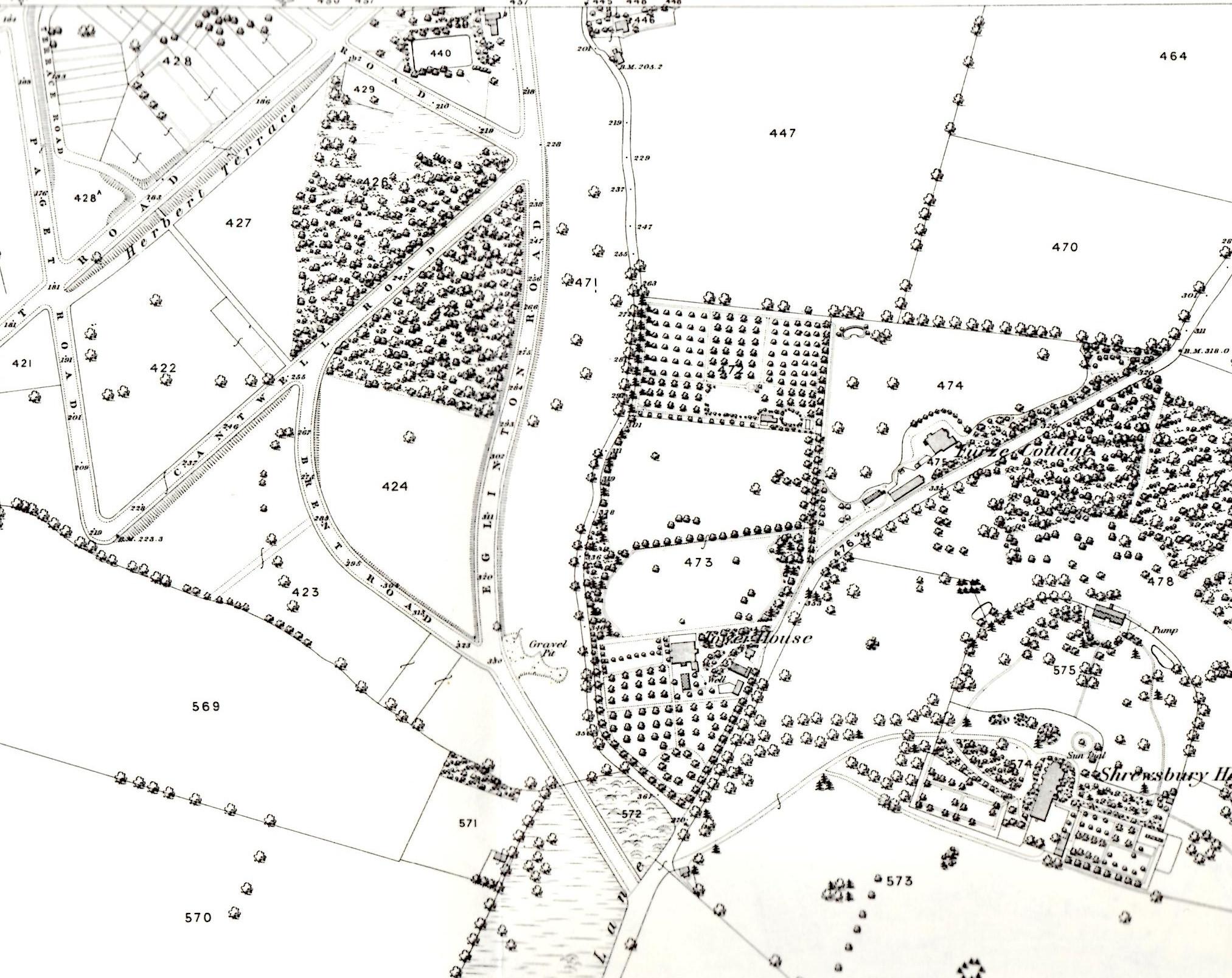
Why do I think that path is Mayplace Lane? Well its northern end is in about the same place – continuing the line of Sandy Hill Road, roughly where Herbert Road is today. But also, in the 1866 OS map from Alan Godfrey shown in my earlier post about Mayplace Lane you can see that Mayplace Lane ends up close to the start of the old Shrewsbury House’s long drive way, which was roughly where the fire station is now. I’ve included the 1866 snippet again below, rotated through 180° so that South is at the top as in the 1837 map. Mayplace Lane winds up the centre of the map. Interesting that in the 29 years between the 1837 and 1866 maps some modern roads such as Eglinton Hill have been constructed – the start of the development of the Herbert Estate by British Land.
Snippet from 1866 OS Map rotated so South is at the top
Another thing that’s been puzzling me about Mayplace Lane, possibly related to gates, is the strange concrete blocks in the ground just past the Bronze Age barrow. You can see them in the photograph below – two rows of three square concrete objects a couple of yards apart. Each piece of concrete has a distinct, separate circle at its centre, as though there was a concrete post which has been cut off level with the ground. Does anyone know what they are or were? There’s nothing on the old OS maps to indicate that there was a gate or barrier at this location, and they look more 20th century than 19th. I wonder if they could be something to do with second world war defence preparations. There were other defensive structures nearby – for example Dragon’s teeth were set up in Eglinton Hill and Brinklow Crescent to impede movements of tanks and mechanised infantry. I’d love to know – but it’ll have to be another topic for my next visit to the Greenwich Heritage Centre.
Poring and peering. I’ve been poring over old maps a lot recently, and peering over walls and fences and into ditches, trying to understand the relationship between the geology of Shooters Hill and the springs and streams that drain it. My investigation took me down to the Greenwich Heritage Centre, both for their beautiful old geological maps and to read what Colonel Bagnold, David Lloyd Bathe and W.T. Vincent had to say about Shooters Hill springs and geology. The Heritage Centre also has a box of old papers from the 1930s by local geologist Arthur L. Leach which discuss the details of the geology and report his observations.
Why did I start on this? I had noticed that some locations on the hill seemed to be always wet, and small streams sprung from them after rain. Streams that couldn’t be explained by the latest Thames Water leak. For example the woods just up the hill from Christ Church School is one streamy spot, and the steep, stony stretch of Mayplace Lane just above Highview flats another. My curiosity was piqued.
The story of the springs of Shooters Hill goes back to the late 17th century and the area was famous for its mineral wells. Hasted records in his seminal 1797 work “The History and Topographical Survey of the County of Kent” that there was on Shooters Hill “a mineral spring, which is said constantly to overflow, and never to be frozen, in the severest winters.” In Henry Drake’s 1866 revision this is interpreted as referring to springs in Red Lion Lane, and is expanded to say that the springs were discovered in about 1675 by John Guy and were called the “Purging Wells”. Bagnold reported that these springs were in the garden of 80 Red Lion Lane, and overflowed across the Lane and down to Nightingale Vale. It was visited by people wishing to take the waters up to the end of the nineteenth century. Diarist John Evelyn and Queen Anne were said to have used the Shooters Hill waters, and at one stage there was a grand plan to turn Shooters hill into a spa town.
The chemistry of the Shooters Hill waters was analysed by the Royal Military Academy’s James Marsh, showing that its main ingredient was Magnesium Sulphate, also known as Epsom Salts. These medicinal springs seem to have different geological origins to other springs on Shooters Hill.
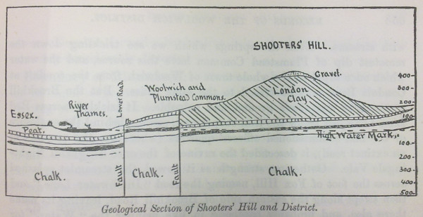
W.T. Vincent’s Geological Section of Shooters Hill and District
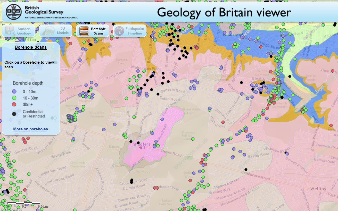
Shooters Hill can be thought of as comprising three geological strata. The bulk of the hill and lowest layer is London Clay. Next is a layer known as the Claygate Beds, which itself is layers of sand and loams with thin bands of clay. On top there is a layer of gravel, known as Shooters Hill Gravel, which Wessex Archaeology describe as “well rounded flint gravel, sandy and clayey in part”. Bagnold describes it as “red, clayey gravel and sands.” It can sometimes be seen when ditches are dug, for example to put down services pipes and cables; there’s a good example at the moment in a fresh ditch by the side of the path leading to Severndroog Castle. The gravel layer is shaped a bit like an irregular doughnut sitting on top of the peak – at the very top of the hill it is very thin or even non-existent and it increases in thickness going down the hill as the Claygate Bed layer drops away more steeply. Leach shows the top surface of the London Clay sloping towards the West-South-West so the Claygate Beds and Shooters Hill Gravel are thicker in the direction of Eltham Common. The gravel is thought to cover an irregular area about a mile long by half a mile wide, as can be seen from the British Geological Survey map extract below.
(As an aside, it has been argued that the geological structure of Shooters Hill, specifically the faults shown in Vincent’s cross-section above, created London.)
The top two layers are porous, and in wet weather retain water, which cannot drain through the impermeable London Clay and so appears as springs at the edge of the upper layers where the clay becomes the surface. The spring above Christchurch school is explained by this mechanism: the BGS map shows that the Claygate Beds layer ends at exactly the point where the spring appears. Bagnold says that up until around the second half of the nineteenth century there was a dipping well at this location, and that it is believed this well was the main source of water for the Shooters Hill hamlet around the Red Lion pub until the Kent Waterworks laid on a water supply.
Other streams and water flows, where maps can be found that show them like Nokia Maps, seem to start from around the edge of the gravel/Claygate layers. For example the origin of ditches on Shooters Hill Golf Course, like the one in the photo at the top, and others in Oxleas Wood seems to lay on the boundary line.
Snippet from British Geological Survey Geology of Britain Viewer
The flow of water in Mayplace Lane is not so easily explained because the map shows that the Claygate Beds layer don’t extend that far and the western boundary of the Shooters Hill Gravel runs parallel to and quite close to Plum Lane. I’m not a trained geologist, but I wonder whether is this is accurate, for two reasons. Firstly the 1866 OS map shows that there was a gravel pit between Eglinton Hill and Mayplace Lane opposite the junction with Brent Road, so there was some gravel that far down the hill, though of course it may have been a pocket of gravel separate from the main layer.
Secondly, Alfred Leach wrote some “Further Notes on the Geology of Shooters Hill, Kent” about his observations of trenches being dug for sewers along Plum Lane from Genesta Road up to Mayplace Lane. Someone else who spent time peering into ditches! He noted that from Dallin Road upwards the trenches passed through sands and pebbles down to London Clay, apart from a few points where the gravel layer went deeper than the 8ft deep trench. That would seem to indicate that the Shooters Hill Gravel extends further north than the BGS map, though Leach thought that undisturbed gravel only extended as far as the midpoint between Furze Lodge and Dallin Road, after that it was gravel that had drifted down the slope. The southern end of Highview flats is on the same 95m contour line as the Plum Lane end of Dallin Road.
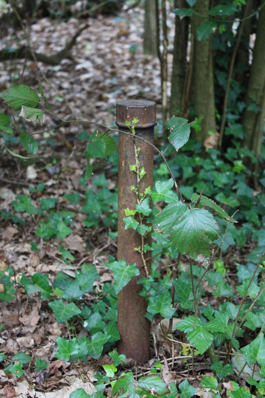
Borehole pipe in the middle of Oxleas Wood on the proposed route of the road to the East London River Crossing
It’s a pity the boreholes, shown on the BGS map, that have been used to gather geological evidence don’t cover the North-west of the hill as well as they cover the proposed route of the road to the East London River Crossing through Oxleas Woods and Plumstead.
Most of the streams and springs originating on Shooters Hill have now disappeared – diverted underground or into the drainage system. As long ago as 1890 W.T. Vincent in his Records of the Woolwich District was bemoaning the loss of streams, and mentioned a number of them. There was the Nightingale Brook which sprang from “the swampy waste behind the Royal Military Academy”, then trickled across Red Lion Lane before descending the “ravine of the once delightful Nightingale Vale”, along the eastern side of Brookhill Road down to the Woolwich Arsenal where “it filled a moat about a barbacan, and finally fell into the bosom of Father Thames.” This stream marked the boundary between Woolwich and Plumstead. Another across Woolwich Common marked the boundary with Charlton.
Vincent also believed that Shooters Hill was the source of the River Quaggy, citing springs which rose behind the police station and crossed the Eltham Road under an arched bridge on its way to Kidbrooke. This sounds like the Lower Kid Brook described by the Kidbrooke Kite in his guide to the Kid Brooks. The Kid Brooks were tributaries to the Quaggy.
On the eastern side of the hill the Oxleas Woodland Management Plan says that Oxleas Wood and Sheperdleas Woods drain into the River Shuttle, which is a tributary to the River Cray, and Nokia Maps shows some streams heading in that direction via Rochester way and Falconwood Field. However I was intrigued by what Bagnold said about some other eastward heading streams. These fed into what Vincent calls “An Obsolete River” and the Plumstead River, and Bagnold asserts was once called the River Wogebourne or Woghbourne. I’ll talk more about my efforts to trace this lost river in my next blog post.
I’ve been wondering for a while about where Mayplace Lane got its name. One possible answer is that it once led to a place where May Day was celebrated, but it has proven difficult to find any written records of May Days on the hill.
The first place I looked was in Neil Transpontine’s excellent booklet “May Day in South London: a history” which is a fascinating social history of May Day activities from medieval to modern times. It includes the story of Henry VIII meeting Robin Hood at Shooters Hill on May Day, which was followed by a procession to Greenwich accompanied by musicians, paste-board giants on carts and 25000 followers. It also mentions a tradition that May Day dew is good for the complexion, and quotes Samuel Pepys arranging a trip to Woolwich to collect the May Day dew, “which Mrs Tuner hath taught here is the only thing in the world to wash her face with”.
Leaving this lane, we enter nearly at right angles into a fair highway, leading on our left over Shooter’s Hill, and to the right towards Blackheath and London. Our road is in the former direction; so bringing “a stout heart to a stone brae,” we prepare ourselves for the lengthened but very gradual ascent of the famed hill, where of yore, at the opening of the merrie month of May, all London, – man and wife, young and old, the small as well as great, – were accustomed to disport themselves. Here a party, clad in Lincoln green would be practising at the butts; some busily adjusting their long yew bows, others examining with jealous care their well-poised fletches, whilst an accompaniment of noisy shouts of officious boys or anxious partisans announced the result of each successive shaft, as it whistled part the ear on its errand of adjudicature as to the archer’s merits. In another direction, perhaps a crowd of amused spectators would be encouraging by their cheers some adventurous smock-frocked knight, to encounter another rough tumble from his heavy carthorse in a mock-joust at the quick revolving quintain. Here, also, around a tall flower-bedecked mast, surmounted by a gaudy popinjay, a circle of youthful dancers, of both sexes, leap joyously to the jarring music of fiddles and tinkling dulcimers, or perchance to the less pretending strains of the humbler pipe and tabor. Warm with exertion and flushed with excitement, the party at length break up, retiring for rest to pleasant bowers or reclining at full length on the soft green turf. These have given place to a boisterous party of lusty competitors, each bearing a clumsy cavalier’s or long arquebuss, and who approach to contend for the prize given for the best shot fired at the popinjay. Not least among the entertainments prepared for the pleasure-seekers to Shooter’s Hill, was the opportunity thus afforded to braggart apprentices, or the sly foresters skilled in the gentle practice of woodcraft, to exhibit their dexterity as marksmen; and on this spot, no doubt, sulky discomfiture and saucy success have fretted their brief hour away.
So maybe Mayplace Lane did lead to May Day merriment.
Mayplace Lane may at first sight seem like a typical back alleyway running to the garages behind houses in Eglinton Hill, but it’s much more than that. As you can see in the snippet from Alan Godfrey‘s 1866 OS Map of Shooters Hill it was there before the houses in Eglinton Hill were built, winding down behind Tower House parallelling Eglinton Hill. The Lane is thought to be part of a track that went all the way down to the Woolwich Marshes, following the line of Sandy Hill Road. According to the Survey of London Volume 48 on Woolwich, Sandy Hill Road itself “was laid out along the line of a footpath that rose diagonally through what had been called Hilly Field”. So it seems that before the roads we now know were laid out Mayplace Lane ran from the Bronze Age barrow in Plum Lane all the way to the marshes that once bordered the Thames.
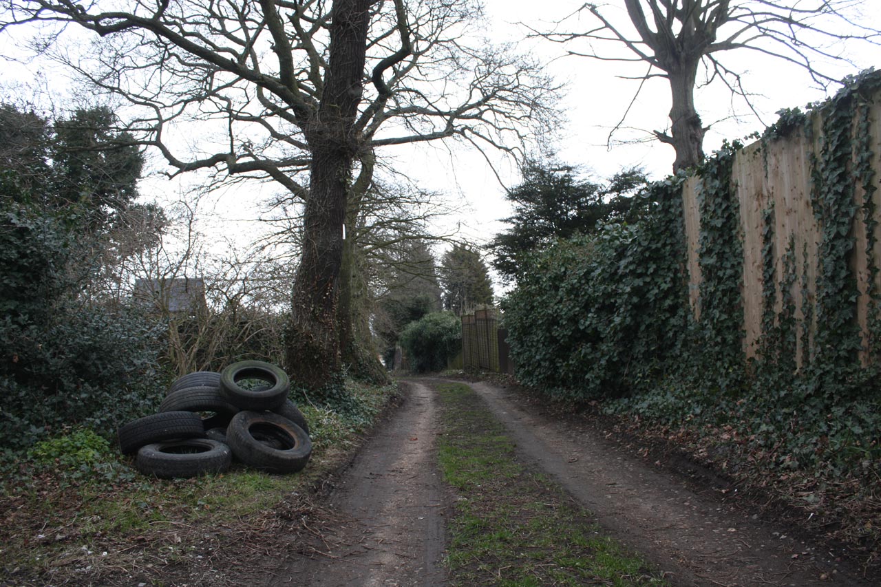
Mayplace Lane with Fly-tipped Tyres
Mayplace Lane is also, in places, a pretty and secluded path, providing a pleasant alternative route down the hill towards Woolwich, though it is a bit uneven in places especially around High View flats where it shares the hill with a permanent water flow of what appears to be spring. Well it would be pretty if it weren’t for the persistent fly tipping which has blighted the lane for years. This isn’t just the usual dumped mattresses, but lorry-loads of old tyres, building remains and, at the moment what looks like corrugated asbestos roofing sheets.,
In the past the Royal Borough of Greenwich Clean Sweep team have removed fly-tipped rubbish, though they maintain that they don’t have to because Mayplace Lane is an unadopted road. Frustratingly the current piles of rubbish have been there for some time and consequently are being scattered over a wider area. A twitter exchange about the rubbish last week has led to e-mails being sent to our local councillors, MP Clive Efford and London Assembly Member Darren Johnson to try to get some action.
One suggestion, which I thought was a good idea, from @Twinsclubplus was that we should have a “Friends of Mayplace Lane”, which I guess would be a bit like the “Friends” groups that look after local parks. It could keep an eye out for fly-tippers, make sure any tipping was reported promptly, perhaps help clear up the Lane and lobby towards getting a more permanent solution to the problem such as a lockable gate up at the Plum Lane end.
Please let me know if you’re interested in being involved with a “Friends of Mayplace Lane” group on the usual e-mail hilly@e-shootershill.co.uk.
Of course fly tipping is not confined to Mayplace Lane: it’s a borough-wide problem which has been going on for years. In the past the local neighbourhood watch and the 853 blog have both explained what to do about it, but here’s a reminder.
Make a note of as much information about the fly-tipped waste as possible, in particular:
Where it is, with the post code if you know it
How much waste there is, from a single item up to multiple lorry loads
What type of waste it is, for example demolition waste, tyres, asbestos …
The type of land it is on, such as a public highway, back alley, private land …
If possible make a note of any information about the fly-tipping incident:
Date and time.
Nearest road junction
Identification of who did it such as a description, car registration number etc
Report it either by:
Phone 020 8921 4661 during office hours (Monday to Friday 8am to 8pm, Saturday and Sunday 8am to 1pm)
We will remove all small flytips (equivalent to a small van load) within 24 hours and, if possible, take action against those responsible.
Large flytips, classified as anything larger than a small van load, will be dealt with by contractors within four working days on a priority basis.
Any items that have been fly tipped at the side of the road will be collected and separated for recycling. Our teams will endeavour to stop and collect any fly tips they find, unless it would prevent them from completing their scheduled or booked work in which case they will report it so a dedicated team will remove the fly tip.
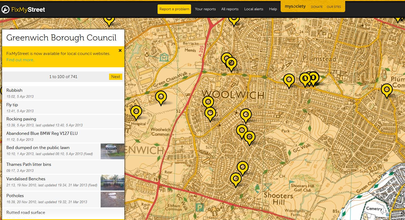
Another way of reporting fly tipping, and other problems, is to use the FixMyStreet web site, which will then forward the report to the council. This can be done either by entering a post code or interactively using their map. It allows you to attach photographs of the problem too. On FixMyStreet you can easily see all the problems reported in your area, as shown in the screen grab below.
Snippet from FixMyStreet web site
I wonder how long Mayplace Lane has been there? It’s intriguing that it runs from the Plum Lane Bronze Age Barrow, one of what was once a barrow cemetery of 6 barrows, down to the Woolwich Marshes. Recent archaeological finds at the Plumstead Crossrail site have suggested that Bronze Age people may have built wooden causeways across the Plumstead Marshes similar to those that spanned the marshlands of the Somerset levels. Bronze Age remains have also been found just over the river in North Woolwich. During the Bronze Age it is believed that people distinguished between the land that they lived in and farmed – the land of the living- and the land of the ancestors where their burials took place. Could Mayplace Lane have been their route from their villages around the Woolwich and Plumstead marshes up to the sacred Shooters Hill summit, the land of their ancestors?