South Circular Road Closure

The Junction of Shooters Hill Road and Well Hall Road

Well Hall Road on the South Circular could be closed for another two days while Thames Water fix a burst water main near the junction with Westmount Road, just outside the entrance to Greenwich Cemetery. The road is closed from the Well Hall roundabout to Shooters Hill Road for all but local access traffic.

This had led to traffic jams and long delays in the last couple of days as traffic tries to find a way round the blocked section of the busy South Circular Road.  Last night it took me almost 15 minutes to drive from the Well Hall Road traffic lights up to the Bull because there was so much stationary or slow-moving traffic.  Alternative routes are quite a distance – either via Falconwood to the east or westward down to the A2, as you can see on the Google Maps snippet below.

Google Maps snippet showing the blocked section of Well Hall Road

It is possible for non-HGV traffic to get round the closed road by going down Broad Walk and along Rochester Way, and north-bound traffic is directed this way by Diversion signs. However Broad Walk is a residential road, with speed bumps, cars parked on both sides of the road and a seven foot width restriction at the Well Hall Road end, so is likely to be congested in the rush hour.

Burst  water mains seem to be a big problem in the current cold weather. According to an article on the Utility Week web site numbers have increased in London and the Thames Valley by 50% since the start of December, with about 1000 leaking or burst pipes being reported to Thames Water.

Update: Well Hall Road will definitely be closed 13/12/2012 and 14/12/2012,  @ThamesWater tweeted: “Hi, the repairs are still ongoing, the road will be closed tomorrow. Sorry for the inconvenience. Shaun” and “We were informed yesterday that it would be closed for another 2 days, so tomorrow should be the last day. Thanks Kate ”

Further update: The road was fully open this afternoon, 13/12, so I guess they must have finished quicker than expected.

The Junction of Westmount Road and Well Hall Road

Red Lion Lane One Way Proposal

Red Lion Lane - One Way Proposal

Highway safety seems to be fairly active theme in the area at the moment, there was the traffic monitoring in cleanthus road last year (not sure what came of that), and the extension of the 20 mph zone to eaglesfield road; now there’s a new speed/vehicle counter on the hill going down to kent, plus the occasional traffic police with lidars round the garden centre, and the new road safety improvements to shrewsbury lane where it meets the main road plus the pedestrian refuges at various stages, and the proposed double yellow lines on the main road round the farm (this will save people getting parking fines when they drive to the lambing day in april)…

Overall it just goes to show that gene selection for fear of spiders and snakes, useful though it may have been in the ancestral environment, is now being replaced by meme selection – i.e. we’re just not scared enough of vehicles yet, so culture has to intervene whilst we wait for the genome to catch up (i.e. all the people who are afraid of cars reproduce more effectively than those who aren’t).

In 2000 Red Lion Lane benefited from traffic calming as part of the 20mph traffic calming measures enjoyed by many roads in the area, and was also turned into a down-the-hill-only road at the top end. At the same time the idea of excusing pavement parking on the bottom end was briefly considered before being, erm, parked. Since then the council have received a number of complaints about drivers having difficulty passing each other on this lower section of the lane, and also complaints about damage to parked vehicles, which presumably happens when things get tight. Efforts have been made to revive the pavement parking idea, but now a more radical measure is being proposed which is to make still more of the lane down hill only.

A mini vote is currently on, mainly to sound out the feelings of those who live on roads that will get the up-hill traffic that currently use red lion lane as a rat run when the junction at the old shooters hill police station gets slow, and so I anticipate that herbert road→paget rise→ankerdine crescent→shrewsbury lane→foxcroft road→eaglesfield road will now become the cut through of choice for those in an, erm, hurry. The other way that through traffic might cut through would be herbert road⇒ripon road⇒eglinton hill⇒eaglesfield road – so it may be that residents in these roads are being polled.

Road Safety Improvements On Shooters Hill

You may have noticed some road works going on around the bull, this is something to do with safety improvements being made to various places along the hill. What I’m just about to reveal was first mentioned on the neighbourhood watch website which now boasts a shiny new design and has changed to cover the shooters hill police ward, presumably in line with its links to the met, which incidentally has a rather whizzy map based site about crime in the area; did you know that this ward has one of the lowest crime rates in the borough.

The changes due to take place are as follows:

  • Provision of an ‘entry treatment’ at the junction of Shrewsbury Lane and Shooters Hill. This will hopefully reduce the number of recurrent collisions with drivers turning out of Shrewsbury Lane on to Shooters Hill.
  • Installation of ‘SLOW’ carriageway markings and red-coloured surfacing on Shooters Hill at the junction with Eaglesfield Road. This in turn should alter driver perception and encourage reduced speed.
  • Installation of a pedestrian refuge island east of Cleanthus Road, very near the water tower. This will provide a safe crossing for people using the bus stops near Eaglesfield Road.
  • Installation of a pedestrian refuge island near Woodlands Farm. This will provide a safe crossing for people visiting Woodlands Farm and the bus stop located opposite on Shooters Hill.
  • Installation of five traffic islands on Shooters Hill towards Welling, in addition to red-coloured surfacing within the central hatching from Shrewsbury Lane to the Greenwich-Bexley Borough Boundary.
  • Installation of a ‘Speed Warning Sign’ on the traffic island near Woodlands Farm.

Let’s hope it works! I personally feel that these changes could have taken the side of the pedestrian a bit more than they did, but there might be a good reason for keeping the traffic moving.

People Against the River Crossing: Were You There?

people against the river crossing
People Against the River Crossing

July the 8th 1993, central government withdraws the Oxleas Woods section of its infamous Roads to Prosperity scheme. The hill is saved!

I’ve been asked whether I’d like to investigate this, and since this is quite possibly one of the most significant things to ever happen here, it seems like a good idea for this site to cover this part of the Shooters Hill story.

Since this is a relatively recent episode, and an example of people power, I’m hoping to include some thoughts from those who participated in and observed the saving of the woods. So, if you were there, and would like to reminisce, I would like to hear from you. If you are interested please get in touch via the email address at the foot of the page.

parc-maps

The map shows how the bypass would have run right through woodlands farm, oxleas wood, and sheperdleas wood to meet the a2

At some point this year a post on this will appear, but for the time being, here’s the oxleas section of an alarm uk publication from 1995 (taken from the limited online information I’ve found so far):

“Whenever I used to visit Oxleas Wood I would visualise the proposed road cutting through it. It’s hard to believe that the woods are now safe. But safe they almost certainly are!

My involvement in the campaign against the East London River Crossing began in earnest in the late eighties. By this time the road had been scheduled for construction for many years and had already been approved by the longest Public Inquiry ever held into a road scheme. That inquiry had lasted 194 days; the transcripts of the proceedings contained 9.5 million words!

Local people, in the form of People Against the River Crossing (PARC) and Greenwich & Lewisham FOE, were fighting a determined and exhausting battle against a scheme which would not only cut a swathe through 8,000 year old Oxleas Woods but would also take out several hundred houses in the quiet and pleasant suburb of Plumstead. But with approval in principle granted, and with the Government, developers and some socialist local authorities strongly supporting the scheme, the odds against stopping it were getting bigger all the time. To achieve victory, a concerted strategy was needed to make Oxleas Wood a big issue locally and give it wider significance – a strategy to make it a symbol of the environmental damage that the road programme was causing and a rallying point for the environment movement. If that could be done, then, given Oxleas Wood’s proximity to Westminster, it might force the Government to back down rather than risk confrontation with a united community and environment movement, in its own “back yard”.

Like all the best campaigns we fought on every level. There were letter-writing stalls at the popular Greenwich market, politicians were systematically lobbied and a well-presented public transport alternative was drawn-up. We organised an “Adopt-a- Tree” scheme; the aim here was to get every tree in Oxleas Wood adopted. As well as bringing in funds and publicity, it would give supporters a real stake in the campaign. And if the worst came to the worst we could invite tree adopters to turn up to defend their tree.

In order to make Oxleas a “line in the sand” for the environment movement, we got some of the large environmental non-government organisations (for example the Wildlife Trusts and World Wide Fund for Nature) to take part in an Oxleas Strategy Group. This helped lock them into a campaign that was ultimately run by local people, but which made the best use of the resources of the national campaigns.

A couple of legal lines of last resort helped propel the campaign into the national news. The Government had failed to carry out an Environmental Impact Assessment for the scheme, as required by European Community law. The heroic European Commissioner for the Environment, Carlo Ripa di Meana, took up this complaint causing Prime Minister Major to hit the roof and interrupt a Commonwealth conference to condemn the EC’s action. The complaint was never seen through by the EC, but the publicity was invaluable, as was that which resulted from a High Court case where the “Oxleas 9” (nine local people) put their assets on the line to take the Department of Transport to court over their failure to provide adequate land in exchange for the damage to Oxleas woods. The case was lost, but Oxleas had caught the public imagination and the pressure on the government was intensifying.

Meanwhile, campaigners were preparing for the worst. A “Beat the Bulldozer” pledge was launched, with the aim of getting 10,000 people to pledge to be there if the bulldozers went in. With the TV pictures of direct action at Twyford Down fresh in their minds, as well as the vivid pictures we had painted of what would happen if they violated Oxleas Wood, the Government backed down.

For me the Oxleas campaign had meant hours of hard work in meetings held in draughty halls on dark, rainy nights trying to get the best campaign that I could. For hundreds of local people it had been years of struggle. Was it worth it? Definitely. Oxleas was a turning point. We’d shown how people power could stop roads, a lesson that was quickly learnt right across the country. We’d shown that the environment movement, when it’s focused and working in harmony with local communities, could win. And of course the peace and beauty of OxleasWood has been preserved.

Jonathan Bray, founder and convenor of the Oxleas strategy group

elrc-map

East London River Crossing Trunk Road

From the oxleas woodland management plan:

The Hedgerow on the eastern side of the meadow is composed of mainly hawthorn (Crataegus spp) with some self-seeded oak. This hedgerow is rather special as it contains some examples of butchers broom (Ruscus aculeatus), which is used as an indicator of ancient woodland, as it rarely grows in regenerated woodland. It was the presence of this plant that aided the campaign to stop the East London River Crossing putting a road through Oxleas Wood. This hedgerow was re-laid in 2004 by the GLLAB New Deal project.

Traffic Modelling

Thames-Map-Big

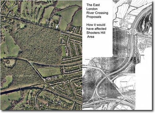
Is Shooters Hill still safe from Ringway 2?

On Tuesday June the 30th I was on the way to work and saw a police biker at the roadside pulling over drivers so they could be interviewed by traffic surveyors modelling journeys on behalf of tfl.

According to the researchers, this particular survey is a routine exercise, and will provide London’s traffic managers with an insight into the toing and froing in this area. This sounds plausible and even sensible, however, it also transpired that similar ‘routine’ inspections are being carried out in east london. Perhaps I was wrong to infer the link, but the utterance of the words east london, south east london, and traffic modelling in one sentence immediately made me think of Ringway 2

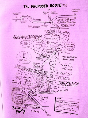
Traffic designs linking the south/north twistulars completing an inner london ring road go back at least as far as the now infamous Ringway 2 blueprint of the 1960’s, and they seem here to stay, in design form at least. These plans were succesfully blocked by the people of south east london in 1973, 1993 and 2008. Things looked especially bad for Shooters Hill in the early nineties, but the area did ultimately fare better than Wanstead and Twyford Down…

On past form at least, Shooters Hill does appear to be safe from the bulldozers for at least another ten years. However the surrounding area may not be, as attention has now shifted to Blackwall. Clive Efford is currently lobbying for a third blackwall crossing, which would include a doglands light rollercoaster to north greenwich and onwards to eltham. His campaign has its merits, primarily it doesn’t have ill intentions for the woods, secondly it makes use of pre-existing links to the south/north twistulars and A2 (which was the original justification for the oxleas woods bypass linking the A2 at falconwood to the crossing at woolwich), and thirdly, the inclusion of a public transport link is a very smart idea as it improves the image of what is, first and foremost, a road building scheme. There are probably some potential traffic problems to be worked out however, and this will be done with traffic modelling!!

If the link at Blackwall gets improved, will it attract more traffic? Will the approach roads and residential areas on each side be able to accomodate extra through traffic?… Furthermore, Blackwall has never had a particularly good record on pollution, air quality measurements at woolwich flyover routinely fail to meet the air quality objectives, what will the building of new roads do for air quality? (Actually for balance it should be added that most of London fails to meet its pollution targets – not that that makes it alright for blackwall to be as bad as it is).

On that note, here’s the survey debrief:

TRANSPORT FOR LONDON: ROADSIDE INTERVIEW SURVEYS

This survey has been commissioned by Transport for London (TfL). Colin Buchanan is conducting it at this site on their behalf.

In order to address transport problems, we need to know more about current travel patterns and so are conducting the survey. It is taking place at a range of locations across the study area. It will last only one day at each location. Stopping vehicles in this way is the only effective way of establishing the volume and types of journeys being made on a typical day.

Thank you for taking the time to provide TfL with this important information.

We would like to apologise for any inconvenience caused by the survey. Every effort has been made to minimise disruption and congestion, but it is not always possible to achieve this as successfully as we would like.

The data you provide will only be used for transport planning purposes by TfL, its agents, London Boroughs and other agencies involved in transport planning.

Should you require any further information about the survey please contact us using the details below. Phones are not continuously manned, but calls will be returned within 24 hours.

Transport for London

T: 02071261423 E: travelresearch@tfl.gov.uk

Colin Buchanan

E: surveys@cbuchanan.co.uk

Three days ago I emailed the supplied contact details to enquire about the motivations for this survey, if I hear back, I will comment further…