Ye who have a spark in your veins of cockney spirit, smile or mourn acccording as you take things well or ill;— Bold Britons, we are now on Shooter's Hill!
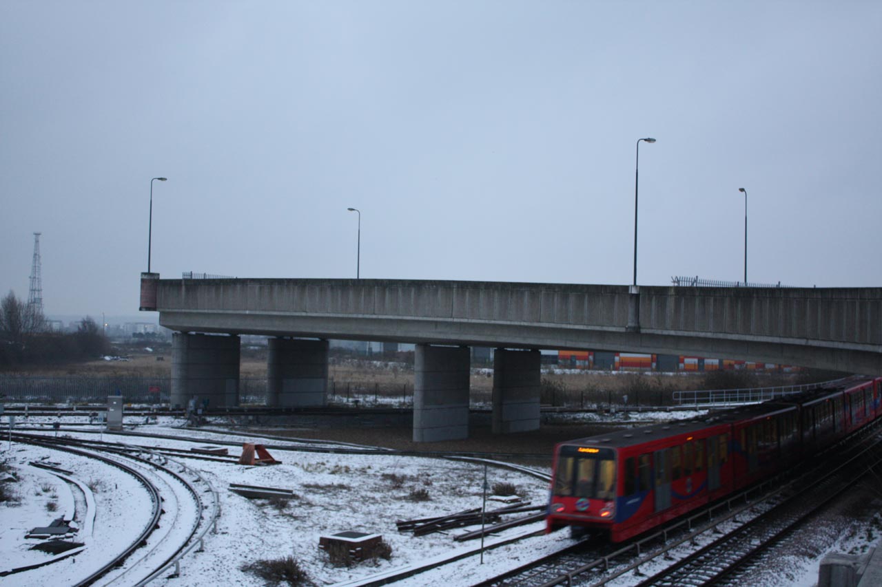
Berkeley Homes are holding a Crossrail station box completion event on the 27th February to celebrate the completion of the 2-year long construction project 4 months ahead of schedule, and to raise money for Demelza House Children’s Hospice and the Berkeley Foundation.
The event offers the opportunity to take a tour of the station box or to participate in a fun run 20 metres below ground level. Tours will last 30 minutes and will start out every half hour between 3.00pm and 5.00pm with a maximum of 20 people per tour. The fun run starts at 6.00pm and, in the words of the Berkeley information leaflet:
With the emphasis on FUN! This will not be a competitive event, there will not be any timekeeping and there will be no winner. In fact the only prizes will be given for the best fancy dress.
The fun run will take place inside the station box, approximately 20 metres below ground level! The size and nature of the space makes this a unique and not to be missed event.
One lap of the station box is approximately 500 metres. Runners are free to run, jog or walk as far as they want within the time limit of (30 to 40 minutes). How far will you get?
The fun run will commence from 6pm. All participants will need to arrive to register and access the station box by 5.30pm.
Fancy Dress – Yes, fancy dress costumes are encouraged. Exciting prizes will be given to those judged to be wearing the best costumes. However, sensible running footwear is essential.
Because of the location of the event it is restricted to people over 14 years old, taller than 1.2m and who are happy traversing a seven storey scaffolding staircase. Anyone under 16 years old must be accompanied by an adult.
Registration is necessary to participate in the event. This can be done either by by phone on 020 8331 7275 or e-mail to woolwichstationbox@berkeleygroup.co.uk. A minimum donation to Demelza House Children’s Hospice of £5.00 is requested for the tour and £10.00 for the fun run. Berkeley will match all donations with a donation to the Berkeley Foundation.
Unfortunately the Herrenknecht tunnel boring machines, Sophia and Mary, won’t have arrived by the 27th – they are on their way from Plumstead.
Completion of the station box is a major milestone for Crossrail, but the funding for the rest of the station is still to be agreed between Berkeley Homes, Greenwich Council and the Department for Transport. Once complete Crossrail will run 12 trains per hour into central London and on to Heathrow. It is expected to lead to an increase in house prices in Woolwich and other areas along the route. Berkeley Homes plan to build 2517 homes in the Royal Arsenal site.
The bridge going nowhere in the photo above is known as the ski jump. It’s a section of road over in Beckton that was built in preparation for the Thames Gateway Bridge, but currently leads to nowhere apart from a dangerous drop. Maybe it’s a metaphor …
I’ve been enjoying reading about the various attempts to create a river crossing between Thamesmead and Beckton over the last few days. It’s a fascinating tale: from the Ringway suggestion back in the 1930s which became Ringway 2 in the 1960s, then the East London River Crossing in the 1980s and 90s, the Thames Gateway Bridge early this century and now TfL’s Gallions Reach Ferry proposal and the Royal Borough of Greenwich’s campaign for a bridge.
The historical background and story of People Against the River Crossing is well told in David Black’s “The Campaign to Save Oxleas Wood” which details the inquiries and court cases, both UK and European, that eventually led in 1995 to the dropping of plans to put a motorway through Oxleas Wood and Plumstead and build the East London River Crossing. A group of local residents known as the Oxleas Nine risked financial ruin from huge legal fees to appeal to the High Court against the compulsory purchase orders needed to allow the roads and crossings to be built.
Unfortunately the documents relating to the 2005 Thames Gateway Bridge Public Enquiry are no longer available online, but those I have seen show a similar level of opposition from local residents concerned about issues such as the health effects of air pollution and the risk to Oxleas Wood from the need for improved road links to the A2.
My reading about the bridge also led me to the Beckton ski jump. It can be seen circled in red on the Google Maps snippet below; it is also one of the possible routes for traffic to TfL’s proposed Gallions Reach Ferry. Its other claim to fame is that it appeared in a car chase in the TV series Bugs, which culminated in a car driving off the end of the ski jump to explode in the waste land beyond. It’s on YouTube here, starting at about 46minutes in.
Google Map snippet showing the Beckton ski jump
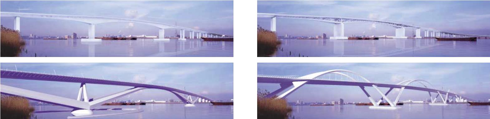
The map also shows another complication to building a bridge here – the proximity and orientation of the runway at London City Airport, which limits the possible height of the bridge. Campaigners in favour of east London river crossings make much of the disparity in the number of crossings to the west and east of Tower Bridge. Two obvious reasons for the difference are that the Thames is wider the nearer it gets to the sea, and large ships sail up the Thames to Central London (and potentially to a cruise liner terminal in Greenwich). Consequently bridges need to be wider and higher and are more expensive to build, which seems to lead to them having to carry more traffic. The artists impressions of the proposed Thames Gateway Bridge, below, from TfL’s brochure show the likely size of a bridge at this location.
Artists impressions of bridge from TfL’s The Thames Gateway Bridge A new bridge for East London
The required height of the bridge means that it has to have longer run-up roads so the overall length is much longer than just the distance across the river, making it very pedestrian unfriendly. Not to mention the high winds in the middle.
When I started writing this post I intended to focus on traffic modelling. I’m not an expert, but it seems to me that changes to the road infrastructure need to consider the whole network because increasing capacity in one place will simply move the bottlenecks to somewhere else in the network, so improvements should be across multiple sites to try to even out the flows. Also traffic management measures need to be included to discourage cars and lorries from small, residential roads. I’m still searching for some comprehensible detail on modelling, but I notice that the recently released East London River Crossings Assessment of Options mentions this issue and confirms my feelings about the impact that a Gallions Reach bridge would have on roads through Plumstead and Bexley:
6.285. The modelling for TGB suggested that it would provide relief for the Blackwall tunnel as well as opening up new travel opportunities further to the east. However, a key issue is that the road network on the southern side is much less developed than on the northern side, where the road would meet the grade separated A406 and A13 as well as linking (via the A406) to the M11.
6.286. To the south, the road would meet the east-west South Thames Development Route, a useful distributor road along the southern side of the Thames, but this is lower capacity than the northern access routes, and is generally not grade separated, with congested junctions in Plumstead, Woolwich and Erith.
6.287. Other routes on the southern side are poorer still, with the roads south into Bexley being largely two lane single carriageway roads, fronted by suburban housing. There was some strong local opposition to the scheme arising from concerns over the impacts in these areas. This led ultimately to the opposition of the London Borough of Bexley to the scheme.
This suggests that a ferry at Gallions Reach would be a better option than a bridge because there is a natural capacity limiting effect from a ferry that will reduce the amount of traffic heading in that direction, though additional action to encourage traffic along suitable roads and away from smaller roads may be needed too. And by analogy with west London perhaps having many smaller scale crossings would be better than one or two massive congestion generating grand projects like multi-lane bridges and tunnels; an argument in favour of keeping the Woolwich Free Ferry as well as the new one. I’d be interested to see the results of traffic modelling with this scenario.
Are there any other possibilities for small east London river crossings, I wonder, and what is the current state of technology for swing bridges?
Friends of the Earth have arranged two public meetings about the crossings – one north of the Thames tonight and another at the Forum in Greenwich next Monday, 28th. They e-mailed with the details:
North side of the river:
Monday 21 January 2013, 7-9 p.m.
St Matthias Community Centre, 113 Poplar High Street, E14 OAE
http://www.stmatthiascommunitycentre.com/contactus.jsp
Nearest station: Poplar DLR
South side of the river:
Monday 28 January 2013, 6.30-8.30 p.m.
Forum@Greenwich, Trafalgar Road, Greenwich, London SE10 9EQ
Councillor Denise Hyland at the launch of Bridge the Gap
The debate about new river Thames crossings for east London has tended to focus on the proposal to construct a new Silvertown tunnel next to the Blackwall Tunnel. Objectors are concerned that increasing tunnel capacity while leaving unchanged the roads that feed the tunnels, such as the A102 Blackwall Tunnel Approach, will lead to an increase in traffic jams and hence an increase in air pollution. A No to Silvertown Tunnel campaign has been started and has launched a petition against the tunnel.
However the proposal to replace the Woolwich Free Ferry with a new bridge at Gallions Reach could have an equally harmful effect on traffic and air quality in residential roads in the east of the Royal Borough of Greenwich, and in neighbouring Bexley. The Google Maps snippet below shows roughly where the proposed Gallions Reach crossing would be sited (there’s an official picture in a previous post). How will traffic get to this new crossing? The consultation documents express the view that “any new tunnel or bridge at Gallions Reach would be likely to be used mostly by local traffic” because most A2 traffic would head for the tunnels at Blackwall and Silvertown, but there is no backup for this view. Just looking at the map it seems equally possible that A2 traffic would leave the motorway at the Bexley or Danson exits and cut across to the new crossing – through residential streets, down narrow Knee Hill or through East Wickham and Plumstead. This seems especially likely if for some reason the tunnel route is closed.
Google Maps snippet showing where the Gallions Reach Bridge would be
The Royal Borough of Greenwich Council is supporting the proposed new crossings, and prefers the option of a bridge at Gallions Reach rather than a ferry. Their Bridge the Gap campaign with Newham Council was launched today, without any trace of irony, near the 124 year old Woolwich Free Ferry which would be closed if the proposals go through. The council believe that building new river crossings is essential to promote economic growth in the borough and create jobs, and they also believe it will reduce traffic congestion and air pollution. They are relying on Transport for London however for the detailed backup to the proposals such as a cost/benefit analysis and traffic modelling. At the launch Councillor Denise Hyland expected most traffic to approach a new Gallions Reach bridge via Western Way, and said she would oppose any future threat to Oxleas Wood from demand for additional traffic capacity between the A2 and the new bridge. I’m not so sure that future councillors would necessarily have the same opinion if faced with major congestion on small roads.
Having sat in traffic queues at both the Woolwich Free Ferry and the Blackwall Tunnel I can sympathise with drivers who have to cross the river regularly, but until some more detailed work has been done on the impact of the new crossing on traffic volumes, including the effect on minor roads, it’s not clear that the proposed new crossings will actually solve the problem and may even make it worse because new roads often lead to increased traffic volumes.
Opponents of the proposed crossings also came along to the Bridge the Gap launch, as you can see in the picture below and on the Kidbrooke Kite blog.
Objectors at the launch of the Bridge the Gap campaign
The Transport for London consultation on the proposals continues until 1st February and we can make any comments on the proposals until then using an online survey with just 14 questions, or by e-mail to rivercrossings@tfl.gov.uk.
Also the London Assembly Transport Committee has arranged a seminar about TfL’s proposals next Wednesday, 9th January. Their e-mail about the seminar gave the details:
Seminar on River Crossings
We want to get people and organisations with different viewpoints to discus the need for additional river crossings in East London. A consultation, currently running, by Transport for London (TfL) is seeking views on options including a road tunnel between Silvertown and the Greenwich peninsula. It has also posed the idea of tolling the new tunnel and Blackwall Tunnel.
This seminar will provide an opportunity to discuss whether there is a need for new river crossings in London, and to consider what options might be needed to address any need for additional capacity. Expert guests (see below) will be invited to raise some of the key issues that need to be taken into account and there will be an opportunity for members of the public to put forward their views and opinions.
The guests who have been invited to take part are:
• Michèle Dix, Managing Director, Planning, TfL
• German Dector-Vega, London Director, Sustrans
• John Dickie, Director of Strategy and Policy, London First
• Richard Bourn, Traffic and Planning Campaigner, Campaign for Better Transport
• David Quarmby, Chairman, RAC Foundation
The seminar will be held from 2-4pm on Wednesday 9 January in the Chamber at City Hall (nearest Tube at London Bridge or Tower Hill). All are welcome to attend. It would be useful if you are able to register your attendance: transportcommittee@london.gov.uk or 020 7983 4206.
The Junction of Shooters Hill Road and Well Hall Road
Well Hall Road on the South Circular could be closed for another two days while Thames Water fix a burst water main near the junction with Westmount Road, just outside the entrance to Greenwich Cemetery. The road is closed from the Well Hall roundabout to Shooters Hill Road for all but local access traffic.
This had led to traffic jams and long delays in the last couple of days as traffic tries to find a way round the blocked section of the busy South Circular Road. Last night it took me almost 15 minutes to drive from the Well Hall Road traffic lights up to the Bull because there was so much stationary or slow-moving traffic. Alternative routes are quite a distance – either via Falconwood to the east or westward down to the A2, as you can see on the Google Maps snippet below.
Google Maps snippet showing the blocked section of Well Hall Road
It is possible for non-HGV traffic to get round the closed road by going down Broad Walk and along Rochester Way, and north-bound traffic is directed this way by Diversion signs. However Broad Walk is a residential road, with speed bumps, cars parked on both sides of the road and a seven foot width restriction at the Well Hall Road end, so is likely to be congested in the rush hour.
Burst water mains seem to be a big problem in the current cold weather. According to an article on the Utility Week web site numbers have increased in London and the Thames Valley by 50% since the start of December, with about 1000 leaking or burst pipes being reported to Thames Water.
Update: Well Hall Road will definitely be closed 13/12/2012 and 14/12/2012, @ThamesWater tweeted: “Hi, the repairs are still ongoing, the road will be closed tomorrow. Sorry for the inconvenience. Shaun” and “We were informed yesterday that it would be closed for another 2 days, so tomorrow should be the last day. Thanks Kate ”
Further update: The road was fully open this afternoon, 13/12, so I guess they must have finished quicker than expected.
Transport for London have started a new round of public consultations about River Thames crossings in the east of London – in particular proposals to build a new tunnel between the Greenwich Peninsula and Silvertown and a new, Gallions Reach, ferry from Thamesmead to Beckton. If the new ferry is approved it would potentially mean closing the Woolwich Free Ferry. The consultation questionnaire also includes questions about the option of a new Woolwich Ferry and about building a new bridge at Gallions Reach.
The new crossings would be funded by charging a toll (about £2 for cars) for the new Silvertown tunnel and also for the existing Blackwall tunnel. The consultation documents don’t say whether any new ferry would be free.
The results of the previous consultation, last February, showed support for a Gallions Reach ferry, but not overwhelming support as the report says:
There was also support for the Gallions Ferry, with over 60% of online respondents supporting or strongly supporting the scheme, but a sizable proportion (14%) neither supported nor opposed it, and 20% opposed it.
Responses to question 8: To what extent do you support the proposal to replace the Woolwich ferry with a new, purpose-built ferry at Gallions Reach?
I wrote about my own concerns about the proposals in February. Apart from the loss of a piece of our history, I don’t think the issue of traffic flow to the new Gallions Reach ferry has been adequately considered. The consultation documents don’t present any data on this, such as traffic modelling, and seems to think that any crossing at Gallions Reach would mainly cater for local traffic. In discussing the proposal for a bridge instead of a ferry it says:
The proposed tunnel at Silvertown would provide a new alternative to the Blackwall tunnel, improving both the capacity and reliability of crossings in that part of London and catering for traffic travelling along the A2. Therefore, any new tunnel or bridge at Gallions Reach would be likely to be used mostly by local traffic. This, and the presence of alternative crossings to the west, mean that the scale of a bridge or tunnel here could be minimised, and we believe that two lanes in each direction would be enough. However, traffic volumes would be higher than with a ferry option, so careful traffic management would be needed to avoid increased delays around the crossing.
However there’s nothing to back up this view, and no consideration of the risk of increased traffic on local roads through Shooters Hill, Plumstead and East Wickham as motorists attempt to cut through to the new crossing, not to mention future threats to Oxleas Wood, Woodlands Farm and Plumstead driven by demands for improved roads to the new crossing.
Comments on the proposals can be made using an online survey with just 14 questions, or by e-mail to rivercrossings@tfl.gov.uk. TfL are holding a series of consultation roadshows about the proposals, including one at Woolwich Library on Saturday 15th December between 10.00am and 4.00pm.
We have until 1st February to submit any comments.
Map extract showing Shooters Hill parking restrictions area
Plans for transport and parking changes for the Olympic Games have been finalised by Greenwich Council, TfL and LOCOG, as you may have seen by the many notices decorating lamp-posts in Shooters Hill, competing with the Jubilee bunting. As expected there will be parking restrictions in Shooters Hill during the games – we will be in an Event Day Zone, or EDZ in the Council’s acronym- laden notices – and we will need to apply for residents parking permits.
The parking restrictions will now be in place from 27th July to 9th September, covering both the Olympic and Paralympic games and the period in between, and will operate every day between 8.30am to 7.00pm. Parking will be allowed for up to 2 hours without a permit, but for over 2 hours a residents or visitors permit will be have to be displayed. Permits will only cover us for the Shooters Hill sub-zone, labelled OC in the Council’s maps, not for any other restricted parking area.
The boundaries of the EDZ look almost unchanged from the original proposal, apart from a slight change round the junction of Upton Road and Ennis Road on the eastern boundary, and a change south of Shooters Hill Road to add in the Royal Herbert Pavilions and the Broad Walk/Mayday Gardens area.
We can check whether we live in a postcode where we need a permit, and apply for the permit, through the Greenwich 2012 Parking Permits web-site – it has separate links for residential and business checks. We have until 14th July to register. There is also a phone number for people who are not on the internet – 0300 777 2012. I found the system a little bit unclear: it told me that my vehicle was already on its database and that I didn’t need to apply for a permit. So I assume I will just be sent a permit within 5 days, as stated on the frequently asked questions list? When I applied for my 2 visitor permits the site says “to activate the permit when your visitor arrives, please click on the Book a visitor button, found at the top left corner of this screen” – there is no such button on the screen. Teething problems I guess.
Ha-Ha Road closed for Olympics test event
There will be two sets of changes to roads – the closures within the events area at the Royal Artillery Barracks and the Olympic Route Network. The road closures will be the same as for the test events in May, as the Royal Borough of Greenwich web site says:
In Woolwich:
there will be no right turn for traffic from Woolwich New Road on to Grand Depot Road during Games time
there will be 38 pre-bookable parking spaces for Blue Badge users on Woolwich Common
Repository Road and Ha Ha Road will be closed to traffic between 7 July and 19 September. However, there will still be full access for emergency vehicles
Congestion on Shooters Hill and Shooters Hill Road increased quite a lot during the test event when Ha-Ha Road was closed; I guess it may be even worse when the games are on as there will be increased traffic and the road restrictions from the Olympic Route Network.
Local snippet from TfL Olympic Route Network mapOlympic Route Network sign
The Olympic Route Network doesn’t come up as far as Shooters Hill, but does effect Charlton Park Lane and Shooters Hill Road between Greenwich and Charlton Park Lane. The main changes as far as I can tell are:
? A “Games Lane” on Shooters Hill Road from Blackheath to the Sun in the Sands roundabout, and then to Eastbrook Road. Only official games vehicles are allowed in the Games lane between 6.00am and midnight.
? Shooters Hill Road to become a “No stopping at any time” road up to Charlton Park Lane, with some roadside parking changed to partial footpath parking.
? Temporary removal of road humps and width restrictions on Charlton Park Lane.
? Changes to some parking on Charlton Park Lane and no stopping at any time along the Lane.
The work needed to create the ORN, such as road markings and traffic light changes, is planned to start at the beginning of July, which I imagine may also have an effect on traffic congestion, and the ORN will be operational between 25th July and a few days after the games end on 12th August, and then the Paralympic Route Network (PRN) will be in place from the 27th August until the Paralympics end on 9th September.
Train and bus services will also be changed during the Olympics. Because of the road closures there will be similar changes to bus routes 161, 178, 291, 386, 469, 486 as there were at the test event last month, including the temporary 561 bus route from Chiselhurst to the Queen Elizabeth Hospital – full details of all the diversions and dates are in the detailed TfL document starting from page 37.
On the trains, the biggest change will be the closure of Woolwich Dockyard station from 28th July to 12th August, as shown on the snippet from the Get Ahead of the Games rail impact tool, below. In addition there will be a reduced service at Kidbrooke, Westcombe Park, Maze Hill and Deptford and it is expected that Greenwich, Charlton, Blackheath, London Bridge and Waterloo will be exceptionally busy during the games – the Get Ahead of the Games web site has details of busy times and dates. Southeastern Trains’ timetables are also changing during the Games.
Sounds like a good time to change commuting times, or even work at home if possible.
Snippet from Get Ahead of the Games interactive rail impact tool
Transport for London have published the dates and details of local bus route changes when the Olympic and Paralympic test events take place over the next month. The changes are needed because Ha Ha Road is closed from 15th April to 7th May and Repository Road from 16th April to 29th April. Bus routes 161, 178, 291, 386, 469, 486 will be affected. A temporary new bus route, the 561, will go to the Queen Elizabeth Hospital from Chiselhurst between 15th and 28th April:
On the days that both Ha-Ha Road and Repository Road are closed, route 161 will not serve Queen Elizabeth Hospital. Instead a new, temporary service – route 561 – will operate between Chislehurst and Queen Elizabeth Hospital (west entrance). This service has been provided in response to concerns from residents in Eltham, Mottingham and Chislehurst. All other routes will continue to serve the hospital via the west entrance.
The world’s top elite marksmen compete in this international rifle, pistol and shotgun competition which also serves as an Olympic qualification and Test Event ahead of London 2012. The 11-day ISSF World Cup event will be the ideal opportunity for both competitors and spectators to get a taste of the historic Royal Artillery Barracks in Woolwich, which will host the Olympic shooting competitions this summer.
International Paralympic archers trial out standing and wheelchair events for individuals and teams in this four-day Olympic test event at the Royal Artillery Barracks in Woolwich. The event is part of the London Prepares series, which runs high-profile tests and trials all all London 2012 venues and for all events ahead of this summer’s Olympic bonanza.
There will only be between 240 and 440 people attending on any one day so it has been decided that the proposed controlled parking zone in the area will not be required. Tickets will not be on sale to the general public, though Royal Greenwich Council will have about 17% of the tickets to distribute to local residents and 6% of tickets will go to local community groups.
Incidentally the Olympics Controlled Parking Zone seems to have changed in the Olympic Delivery Authority document from the previous map – the shapes of the borders are different. I guess the details are still under discussion, but I’m sure “they” will let us know before 27th July.
If you think the the Woolwich Free Ferry should continue, or you think a Gallions Reach ferry would lead to unacceptable traffic problems, or if you object to a new tunnel at Silvertown, or if you want to make any other comments about Transport for London’s river crossing proposals then you have until midnight of the 5th March to complete the consultation questionnaire. As I mentioned in a previous post, the Ferry could be gone by 2017 if TfL’s latest proposals on Thames crossings are implemented.
There seems be be strong affection for the Free Ferry; in the 2003 consultation about the Thames Gateway Bridge 76% of respondents thought the ferry should be kept open. As the TfL consultation key findings brochure says:
“ If the bridge would lead to the closure of the Woolwich Ferry, I would be strongly opposed to the bridge.”
Over three-quarters of respondents to this question (5,086 in total) said that the Woolwich Ferry should be kept open in some form.
3,537 people added comments to this question.
Many respondents said that they would oppose the bridge if it simply replaced the ferry.
The market research confirmed this finding, with 69% of respondents wanting the Ferry to be kept open.
The consultation on the new proposals is open until midnight on Monday. It only takes 5 minutes to complete – just 17 questions including the age, ethnicity etc. questions – and allows you to say whether you support the new Gallions Reach ferry and Silvertown Tunnel.
Woolwich Celebrates the opening of the Woolwich Free Ferry
The earliest that a ferry is recorded as running across the Thames at Woolwich is in 1308 when it was sold for £10. There was also a privately run ferry in the early 1800s, established by an act of Parliament in 1811. Later in the 19th Century, after pressure for a ferry from Woolwich residents, the Free Ferry was instigated by the Victorian engineer Sir Jospeph Bazalgette, better known as the builder of London’s sewage system. It has been part of Woolwich life for over 120 years. It was opened on Saturday 23rd March 1889 by Lord Roseberry – an occasion for a major celebration in Woolwich, illustrated in the picture on the right posted by Mary Mills on twitter. In 1996/7 the ferry carried over 1 million vehicles and approximately two and a half million passengers, around 2000 vehicles a day southbound and 1500 northbound.
Personally I think it would be a great shame if we lost the ferry; I use it occasionally, and usually find it quite an efficient and relaxing way to get over to the north circular and Essex – when there’s no problems and two ferries running of course. However I’ve experienced quite long delays there as well, and can sympathise with commuters who have to cross the river regularly when the service is impaired.
Sentiment aside I have a couple of concerns about the proposed new ferry at Gallions Reach. Firstly, where will the traffic for the ferry come from? Some, I assume, will come from the direction of the Woolwich Ferry – heading down the South Circular then turning right along Woolwich High Street to Thamesmead and the new ferry. How much will be tempted to take an earlier right turn and cut across through Shooters Hill or Plumstead I wonder? And what about the traffic that comes in to London on the A2 – again how much will cut across through East Wickham and Plumstead to get to the new ferry. It seems very likely that there will be an increase in traffic along streets that aren’t designed for heavy use.
The increase in traffic will lead to demands for improved roads and before we know it Oxleas Wood and Woodlands farm are under threat again – a subject of previous posts on this blog. It appears to be a re-run of the very old plans for Ringway 2. The Google Earth snippet below is taken from an overlay provided by the cbrd.co.uk web site’s excellent UK roads database. It shows Ringway2 running down through Oxleas Wood and Woodlands Farm, ploughing across Plumstead to Western Way and thence to the Thames. Underneath is an extract from the TfL consultation documents showing the proposed new road to connect to the Gallions Reach ferry. Spot the difference!
CBRD (Chris’s British Road Directory) Google Earth overlay for Ringway 2TfL map extract showing route to new Gallions Reach ferry
My concern is aggravated by suggestions in a 2009 presentation by a TfL Planning Manager that the Gallions Reach ferry could be replaced by a fixed link (i.e. a bridge) “depending on local development and demand, and impact of congestion relief at Blackwall and Dartford.” Sounds like that could lead to Ringway2 by stealth.
I’m also concerned about the effect of the proposed development on people living in Thamesmead. I went for a walk up Gallions Hill yesterday to take a look at the route of the proposed new road. I was immediately struck by the loud and frequent aircraft noise. The area is directly under the flight path for London City Airport and aircraft are quite low here on their landing approach. I was also struck by the landscaping and rows of new, young trees that had recently been completed on the land to the North-west where the new road would run; it has been converted into a park, soon to open to the public. So residents would have a major road and ferry port to add to the aircraft noise, and potentially lose a new park!
Panoramic view from Gallions Hill looking North-west
The consultation on the new proposals is open now. It only takes 5 minutes to complete – just 17 questions including the now standard ones on age, ethnicity etc. – and allows us to say whether we support the new Gallions Reach ferry and Silvertown Tunnel. It runs to midnight on 5 March 2012.
I just caught the LOCOG/Greenwich Council/TfL stand in General Gordon Square about traffic management during the games before the wind and rain blew them in to Woolwich Library. They will be there again tomorrow (weather permitting I guess), and they have published some, but not all, of the displays on the London 2012 web site.
The proposed road closures weren’t surprising. Roads around the Olympics venues – Ha-Ha Road, Circular Way and perhaps less expectedly Repository Road – will be closed. There will be a checkpoint for traffic coming along Charlton Road, with all non-games traffic diverted down Stadium Road. Buses will be diverted around the closures.
The main impact proposed for us Shooters Hill residents will be a large extension of the residents parking zone across the hill, as shown in the extract from the map, above. The additional area is North of Shooters Hill Road, bordered on the East by the Golf Club and Shrewsbury Park, Wrekin Road and Ennis Road down to the Common then down to join the current restricted parking zone round Plumstead Station. Details of how we can get parking permits, including permits for visitors, will be communicated “early in 2012”. The web site does say that we are entitled to visitor permits, but not how many.
Providing they get all the details right this sounds like a good way to deter Olympic games spectators from filling all the roads around the venues with parked cars, with not-too-much impact on residents. Parking fines are likely to be increased to £200 for the duration of the Games.
If you want to comment on the proposals, and can’t get along to the drop-in session, the London 2012 web site gives the following methods: