Ye who have a spark in your veins of cockney spirit, smile or mourn acccording as you take things well or ill;— Bold Britons, we are now on Shooter's Hill!
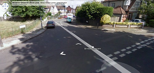
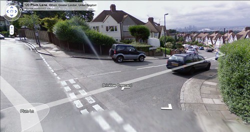
The Newsshopper’s Nina Massey recently published a report on the local opposition to the pavement widening at Brinklow Crescent (which according to the paper is in Eltham, oops, wonder how that mistake happened!). Brinklow is a `true’ crescent, and its semi-circular shape curves round the hillside elegantly to meet Plum Lane at each tip. Both junctions have been modified, although it’s the changes on the west side that seem to be causing the most controversy.
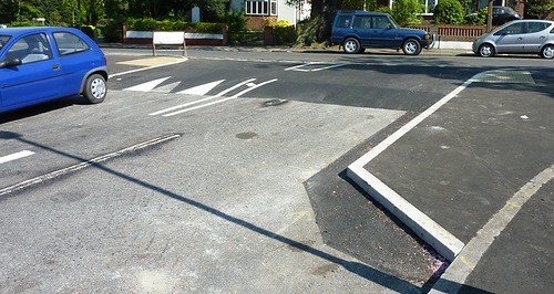
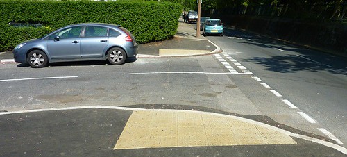
It’s a curious tale because the work, which was carried out in the name of pedestrian safety, and includes tactile paving, a raised crossing at pavement level, and a wider pavement, has also created a narrower road, which has led to difficulties with cars passing each other…
Apparently someone from the council is going to meet the residents to talk this through.
Here’s the report:
GREENWICH Council has apologised to residents for failing to consult with them over residential roadworks.
No consultation was carried out before roadworks started on April 4 to narrow the entrances to Brinklow Crescent in Eltham.
Mother of two, Inderjit Gill, said: “We just don’t know why they’ve done it and what is even worse is that we weren’t consulted.
“Two cars used to be able to pass at the same time, but now that’s not possible.”
The 50-year-old added: “I don’t accept the council’s apology. It’s too late now and the damage has been done.”
Greenwich council has said the works were carried out to improve safety for cyclists and pedestrians.
Paul Revel, a web editor who has lived on the road for almost 10 years said: “In all the time I’ve been living here, I have not witnessed any issues with pedestrian or cyclist safety.
“I would have liked to be told what was happening, especially as we ultimately pay for the road works.”
A spokesman for the council said: “Local residents should have been consulted on these proposals and we apologise that this usual process was not followed on this occasion. “
“Council officers are investigating how this error occurred so that we can ensure it does not happen again.”
Here’s some photos of what it used to look like, (taken from streetview pictures which were I believe last done in 2009).
This is the western tip of the Crescent, as can be seen it is quite wide for pedestrians, although apparently it’s historically safe, and there’s no official record of any accidents there going back as far as 1995.
Here’s what it looks like now.
This is the eastern tip of the Crescent, it certainly has a commanding view of casino wharf. Again, according to records, pedestrians here also appear to have been historically good at car avoidance.
Here’s what it looks like now.
So, altogether this raises two questions: (a) why did these road safety works happen when they did – are they part of a wider plan for the area? (b) why haven’t members of the community been involved – if they had been, would it have been done differently, or at all?
Last year I uploaded a sound recording of the model railway at falconwood, well now here’s a video to go with it. It was filmed whilst holding on to the driver with one hand and the camera with the other, which looking back on it was probably a bit reckless and could have ended up with me falling into the suspension bridge, but in a way it was worth a bit of a risk. I especially like the bit where we go through the tunnel and you can see the steam on the lens, plus all the friendly bystanders of course.
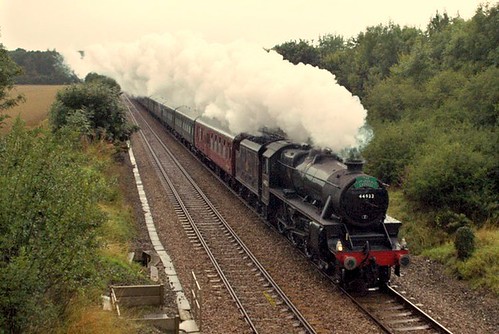
Judging by the relatively large amount of visitors this website receives via its post on the falconwood model railway[1. Welling and district model engineering society], it seems that there is much enthusiasm for steam trains in these parts, and so it gives great pleasure to announce[2. Thanks to 853, ianvisits, and event sponsors sheperd-neame, the journey itself is being run as part of a two day hop festival in faversham this weekend.] that this train will most likely be passing through falconwood on it’s way to kent having left london bridge at 0955 on sunday september the 5th and due to arrive at faversham at 1145. The train is expected back at london bridge at 2000, but it’s coming back a different way.
I say most likely going through falconwood station as the journey is advertised as passing bexleyheath, which is on the same tfl line as our station, whether or or not the same goes for special services I’m not sure. As a provisional guestimate, and pending the actual departure times, I would reckon that the train might come through the falconwood at around 1015-1100.
London, Midland & Scottish Railway "Black Five" No. 44932 (this is not at falconwood by the way)
I just read an interesting bit of news on the neighbourhood watch site, Apparently we hillians are being encouraged to collect data on speeding drivers, and relay this to the met’s traffic police via 999:
Sergeant Barry Edge confirmed the issues of speeding drivers around Shooters Hill could be tackled by getting the traffic division of the Met Police involved, but this will only happen if more residents call the issues in.
We need your help in calling any issues of speeding drivers, logging the date, time and registration numbers.
So, provided any speed freeks don’t whizz by too fast, and the vital statistics can be taken, why not 999 it (noting that callers are sometimes interrogated about themselves as well as the dangers they see).
According to the latest police report for this ward, local safety is up on the last quarter, so collecting previously unknown information on speeding would support new safety initiatives in the area (such as solar powered smiley/frowny faces), and perhaps even give the police the odd chance of a go in the helicopter.
Recently it’s been observed that fixed penalty notices are being handed out in the area for pavement parking. The council are possibly going to apply this law more intensively now as they are probably getting fairly desperate for cash, what with central government pulling the plug on building three borough schools, so drivers beware… pedestrians however can probably enjoy having a bit more of their space back.
Well, the banking crisis is strongly starting to make itself felt in the selondon area now. This week, various blogs (including london reconnections and 853), have covered a recent commons debate that was secured by nick raynsford, and rather defensively fielded by the new minister for transport, theresa villiers (a tory i think). The debate was on the future of crossrail in woolwich specifically and possibly selondon as a whole, and it’s not looking good. The inclusion of Woolwich in the scheme was originally achieved on the back of a 2008 assurance by Berkeley Homes to pay £150 million for the station, which helped the public by reducing government spending on getting the line from Canary Wharf to Abbey Wood. Now it seems that Berkeley Homes are struggling to meet their commitments, because of the banks, and the Government look likely to use this to justify the dropping of the woolwich terminal or the entire selondon spur from the programme.
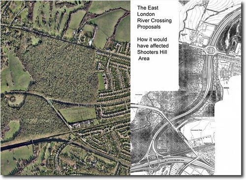
Obviously people can still get to East London and the City via the wonderful new DLR line from Woolwich Arsenal Station, and Villiers made a point of this, but Raynsford then pointed out that instead of the 2.4 million predicted journeys in year one of woolwich DLR, there were actually 5 million through this station; anyone who uses it in the rush hour will know that overcrowding is a problem. Furthermore, Crossrail would have been really good for links with other parts of London (see map), and would have been a much more popular and clean connection with our neighbours in the east than the proposed thames gateway bridge would have been.
Villiers closed the debate by washing her hands of Berkeley Homes, whilst saying that she would try to help Greenwich Council and other ‘interested parties’ to try to help Berkeley:
I know that Greenwich council is actively engaged in the issues that we have discussed this evening. It is now important for all of us who care about Crossrail to assess thoroughly the possible alternative funding sources that could be available between the interested parties if Berkeley Homes does not step up to the plate and deliver what it promised. Therefore, while I cannot promise additional funding from the Department and the taxpayer, we do stand ready to try to help the interested parties find a solution to enable Woolwich station to go ahead. The right hon. Gentleman can have my absolute assurance on that.
Who these ‘interested parties’ are I’m not sure, I suppose I am, but i’m not really in a position to lend Berkeley 150 million, and I doubt if Greenwich Council are either. I hope that Canary Wharf (who are also paying for their station) consider standing Berkeley the cash, considering the massive profits currently enjoyed there, might they be persuaded?
… I fear that if Woolwich goes, the entire selondon spur will be sacrificed.
Don’t worry though, Villiers offered this by way of consolation:
…it is worth noting that several important programmes in recent years have benefited his [nick raynsford’s] constituency, such as the refurbishment of the East London line as part of the London overground network [hmm, brockley isn’t in raynsford’s constutuency], new interchanges with the tube and bus networks [the dome?], and the extension of the docklands light railway [yes, it’s brilliant, but overcrowded at times].
She forgot to mention that the waterfront transit scheme has also been dropped…
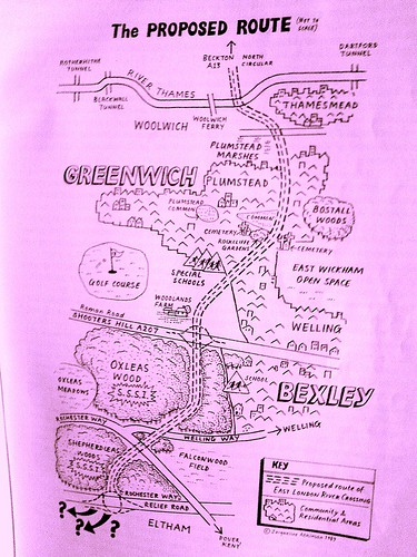
Ringway 2 Proposed RouteA recent discussion over on plummy mummy’s website, has reawakened my interest in the incredible story of the long (and so far successful) struggle of the residents of south east london against the urban motorway planners that just will not go away: the creators of the dreaded ringway2/elrc/tgb historical trilogy of vastly unpopular road building schemes.
In an effort to win favour with the people, the proposal has actually been watered down each time; starting out from a bold 1960’s dream/nightmare of a three carriageway bypass running through oxleas wood, the blueprint was gradually scaled down, ending up with the most recent suggestion that through-traffic could simply drive down residential streets to access the so-called ‘local’ bridge that the tgb was supposedly going to be.
Well, thinking back to the state of play in the 1970’s, if you are curious which parts of the area would have been concreted over if ringway2 been built, there is a website that can demonstrate! A motorway enthusiast, who runs an online road directory has painstakingly researched the history of the London Ringways, and has produced an accurate map showing what the route would have been. [click on the image to zoom].
You may have noticed some road works going on around the bull, this is something to do with safety improvements being made to various places along the hill. What I’m just about to reveal was first mentioned on the neighbourhood watch website which now boasts a shiny new design and has changed to cover the shooters hill police ward, presumably in line with its links to the met, which incidentally has a rather whizzy map based site about crime in the area; did you know that this ward has one of the lowest crime rates in the borough.
The changes due to take place are as follows:
Provision of an ‘entry treatment’ at the junction of Shrewsbury Lane and Shooters Hill. This will hopefully reduce the number of recurrent collisions with drivers turning out of Shrewsbury Lane on to Shooters Hill.
Installation of ‘SLOW’ carriageway markings and red-coloured surfacing on Shooters Hill at the junction with Eaglesfield Road. This in turn should alter driver perception and encourage reduced speed.
Installation of a pedestrian refuge island east of Cleanthus Road, very near the water tower. This will provide a safe crossing for people using the bus stops near Eaglesfield Road.
Installation of a pedestrian refuge island near Woodlands Farm. This will provide a safe crossing for people visiting Woodlands Farm and the bus stop located opposite on Shooters Hill.
Installation of five traffic islands on Shooters Hill towards Welling, in addition to red-coloured surfacing within the central hatching from Shrewsbury Lane to the Greenwich-Bexley Borough Boundary.
Installation of a ‘Speed Warning Sign’ on the traffic island near Woodlands Farm.
Let’s hope it works! I personally feel that these changes could have taken the side of the pedestrian a bit more than they did, but there might be a good reason for keeping the traffic moving.
July the 8th 1993, central government withdraws the Oxleas Woods section of its infamous Roads to Prosperity scheme. The hill is saved!
I’ve been asked whether I’d like to investigate this, and since this is quite possibly one of the most significant things to ever happen here, it seems like a good idea for this site to cover this part of the Shooters Hill story.
Since this is a relatively recent episode, and an example of people power, I’m hoping to include some thoughts from those who participated in and observed the saving of the woods. So, if you were there, and would like to reminisce, I would like to hear from you. If you are interested please get in touch via the email address at the foot of the page.
The map shows how the bypass would have run right through woodlands farm, oxleas wood, and sheperdleas wood to meet the a2
At some point this year a post on this will appear, but for the time being, here’s the oxleas section of an alarm uk publication from 1995 (taken from the limited online information I’ve found so far):
“Whenever I used to visit Oxleas Wood I would visualise the proposed road cutting through it. It’s hard to believe that the woods are now safe. But safe they almost certainly are!
My involvement in the campaign against the East London River Crossing began in earnest in the late eighties. By this time the road had been scheduled for construction for many years and had already been approved by the longest Public Inquiry ever held into a road scheme. That inquiry had lasted 194 days; the transcripts of the proceedings contained 9.5 million words!
Local people, in the form of People Against the River Crossing (PARC) and Greenwich & Lewisham FOE, were fighting a determined and exhausting battle against a scheme which would not only cut a swathe through 8,000 year old Oxleas Woods but would also take out several hundred houses in the quiet and pleasant suburb of Plumstead. But with approval in principle granted, and with the Government, developers and some socialist local authorities strongly supporting the scheme, the odds against stopping it were getting bigger all the time. To achieve victory, a concerted strategy was needed to make Oxleas Wood a big issue locally and give it wider significance – a strategy to make it a symbol of the environmental damage that the road programme was causing and a rallying point for the environment movement. If that could be done, then, given Oxleas Wood’s proximity to Westminster, it might force the Government to back down rather than risk confrontation with a united community and environment movement, in its own “back yard”.
Like all the best campaigns we fought on every level. There were letter-writing stalls at the popular Greenwich market, politicians were systematically lobbied and a well-presented public transport alternative was drawn-up. We organised an “Adopt-a- Tree” scheme; the aim here was to get every tree in Oxleas Wood adopted. As well as bringing in funds and publicity, it would give supporters a real stake in the campaign. And if the worst came to the worst we could invite tree adopters to turn up to defend their tree.
In order to make Oxleas a “line in the sand” for the environment movement, we got some of the large environmental non-government organisations (for example the Wildlife Trusts and World Wide Fund for Nature) to take part in an Oxleas Strategy Group. This helped lock them into a campaign that was ultimately run by local people, but which made the best use of the resources of the national campaigns.
A couple of legal lines of last resort helped propel the campaign into the national news. The Government had failed to carry out an Environmental Impact Assessment for the scheme, as required by European Community law. The heroic European Commissioner for the Environment, Carlo Ripa di Meana, took up this complaint causing Prime Minister Major to hit the roof and interrupt a Commonwealth conference to condemn the EC’s action. The complaint was never seen through by the EC, but the publicity was invaluable, as was that which resulted from a High Court case where the “Oxleas 9” (nine local people) put their assets on the line to take the Department of Transport to court over their failure to provide adequate land in exchange for the damage to Oxleas woods. The case was lost, but Oxleas had caught the public imagination and the pressure on the government was intensifying.
Meanwhile, campaigners were preparing for the worst. A “Beat the Bulldozer” pledge was launched, with the aim of getting 10,000 people to pledge to be there if the bulldozers went in. With the TV pictures of direct action at Twyford Down fresh in their minds, as well as the vivid pictures we had painted of what would happen if they violated Oxleas Wood, the Government backed down.
For me the Oxleas campaign had meant hours of hard work in meetings held in draughty halls on dark, rainy nights trying to get the best campaign that I could. For hundreds of local people it had been years of struggle. Was it worth it? Definitely. Oxleas was a turning point. We’d shown how people power could stop roads, a lesson that was quickly learnt right across the country. We’d shown that the environment movement, when it’s focused and working in harmony with local communities, could win. And of course the peace and beauty of OxleasWood has been preserved.
Jonathan Bray, founder and convenor of the Oxleas strategy group
The Hedgerow on the eastern side of the meadow is composed of mainly hawthorn (Crataegus spp) with some self-seeded oak. This hedgerow is rather special as it contains some examples of butchers broom (Ruscus aculeatus), which is used as an indicator of ancient woodland, as it rarely grows in regenerated woodland. It was the presence of this plant that aided the campaign to stop the East London River Crossing putting a road through Oxleas Wood. This hedgerow was re-laid in 2004 by the GLLAB New Deal project.
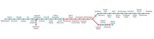
Part x in an occasional series on maps. This little beauty came via the mighty 853, who reported on the forthcoming oysterisation of overground train fares in this neck of the woods. Local stations are now included on arguably one of the all time classic maps, the present day version of the London Underground map, a.k.a the integrated TfL map. As you can see we have the blue line (charing x and canon st), and the green line (victoria) – I would have preferred primary colours myself, but they were all spoken for… I’m not mad on the parallel lines either, as they look a bit hollow, but I’m guessing the designers were trying to differentiate the overground services by tapping in to how people visualise train tracks.
In Mr 853’s post, the title of which contains the phrase the “great train robbery”, he also notes that fares are set to rise, let’s have a look:
Currently: A so called anytime single to London Terminals from zone 4 stations is £3.70, with peak/off-peak returns at £6.20/£4.70 respectively, (for all the confusing details about zone 1 connections, daily cap changes, changes to peak times etc see his pricing post) or the full proposed pricing document.
Presently: Comparative trips using oyster fares will cost £3.10/£2.30 (peak/off-peak) single, this is already significantly cheaper than £3.70!). Return prices will vary a bit depending on the time of travel (e.g. the dreaded afternoon peak from 4-7pm), but let’s consider a pleasant scenario for the sake of optimism: a nice little day trip to trafalgar square on a sunny weekend in january, with no onward connections from charing x: this will cost someone over 16 £4.60, which is actually cheaper than current fares by 10 pence.
There are various catches that even out the price differences, such as the premium train users pay if they connect with other TfL services in Zone 1, and apparently season ticket holders are going to pay extra, and there are further criticisms of south eastern trains in particular for not going above and beyond the call of duty by making eco-friendly travel to bluewater more accessible (as has been done for lakeside), but overall, it’s good to welcome in these long overdue changes.
GREENWICH Council has apologised to residents for failing to consult with them over residential roadworks.