Ye who have a spark in your veins of cockney spirit, smile or mourn acccording as you take things well or ill;— Bold Britons, we are now on Shooter's Hill!
Sat 30th November, is the Woodland Trust Tree Charter Day, and the Friends of Oxleas Woodlands will have a stall near the Oxleas Wood Café, between 10.30 – 2pm (approx.) where we will be offering some guided walks (as well as self-guided walks), talking to people about the Woodland Charter and Oxleas Woodlands, and organising some family activities like Bark and Leaf Rubbing, woody identification, colouring in activities, and also encouraging youngsters to plant an acorn in a pot and take it home to grow – with a view to bringing it back and planting it in the woods next year.
Tree Charter day is celebrated on the last Saturday of November each year. The Woodland Trust describes it as: “a day for the whole of UK society to unite in celebrating the value and importance of trees and woods to people. “
The first of the three is next Friday, 23rd August in Shrewsbury Park. Kris, Chair of the Friends of Shrewsbury Park, sent me details:
Bat walk Friday 23 August – 8.15pm After a short intro next to the notice board by the Plum Lane car park, Les Clark will lead us through the woods and glades where the bats hang out. Bat detectors supplied. Booking essential – eventbrite.co.uk/e/bat-walk-shrewsbury-park-se18-tickets-55871554323 *Wear sturdy shoes and weather-appropriate clothing *Children must be accompanied by an adult *Walk lasts about 1 ½ hours and small torches are useful *Dogs must be kept on a lead If you have mobility issues or enquiries please contact us on werfsp@gmail.com and we will help you participate. The trail is a mix of paved path, gravel and grass. If it’s raining neither bats nor us will come out!
The Woodlands Farm bat walk is the following week, on Thursday 29th at 7.30pm, but I see from their web site that it is already fully booked.
The following day, Friday 30th August, the Friends of Oxleas Woodlands have their bat walk. Their August Update gave details:
Bat Detecting Friday 30th 8pm Meeting at dusk we will use bat detectors to track down these nocturnal residents in their natural woodland habitat. The Friends of Oxleas Woodlands is a community organisation run by volunteers. Walks are free for members & under 16s, otherwise £3 and need to be booked at suereeve@virginmedia.com
Lots of opportunities for night-time walks in our local green spaces hunting for bats.
Sophie the Serotine Bat, one of Jenny Clark OBE’s educations bats
Brown Long-eared Bat, one of Jenny Clark OBE’s educations bats
The Friends of Oxleas Woodlands have had an amazing first year, and continue with a full programme of events for 2019, including a Family Walk this Sunday, a Bat Walk on May 10th and activities in May to mark the Tree Council’s Walk in the Woods month. They have made great progress in the restoration of the rose gardens in Castle Wood and Jackwood, have set up additional Conservation Working Party sessions and litter picks and continued to campaign for the preservation of the woodlands. And that’s not to mention the Houses in the Woods walks, their Gardeners Question Time at Shrewsbury House and rose pruning workshops.
The work on the rose garden restoration has been particularly impressive, with many volunteer hours put in to clearing and mulching the beds, in association with the Royal Borough of Greenwich Parks Department. They have plans to re-plant the beds with 265 roses and create interpretation boards, which will include information about the varieties of rose planted, the history of the woods, the Friends of Oxleas Woodlands and the names of donors. They are crowdfunding to pay for the roses and boards: to donate go to: https://www.justgiving.com/crowdfunding/freindsofoxleaswoodlands-fow
Each £15 donation will sponsor a rose in either your name or the name of a loved one, which can be displayed on the new interpretation board.
The Friends’ next public event is the Family Walk on Sunday. Their events flyer gave the details:
Guided Walk : Seasonal Family Walk – Sunday 28 April at 10.30am. FEEL a tree, SEE spring plants, LISTEN to birds and other forest animals. This guided walk is designed for accompanied children aged 5 years and upwards. Please note that all places on Guided walks must be booked in advance and you are advised to let us know if you are coming to any of the activities as there may be changes to where and when we meet. You can contact us at suereeve@virginmedia.com for activities or oxleasfriends@virginmedia.com for general enquires or visit our website www.oxleaswoodlands.uk
Ladies Smock (Cardamine pratensis) in Oxleas Wood
Stitchwort in Oxleas Wood
The Friend’s programme for May is included below, though I suspect there will be additional events to mark Walk in the Woods month:
Celebrate Oxleas Woodlands by joining us on Monday 6th May at Oxleas Woods Café from 11am. This Bank Holiday Special is part of the Tree Council’s Walk in the Woods month. We will have free activities for all the family, including guided walks, maps, tree dressing, bark rubbing and more. Guided Walk: Dawn Chorus on Saturday 4th at 5am. An early morning walk identifying the birds as they fill our ears with their morning songs, followed by an optional breakfast at the café. Booking your place on this walk is essential. Rose Garden Restoration: Saturday 4th at 10am. As well as weeding the beds we hope to be choosing the mix of rose varieties for the eleven beds that we will be planting in Autumn Walk in the Woods Celebration of Oxleas Monday 6th from 11am onwards. A range of Free activities for all the family. Including guided walks, maps, tree dressing, bark rubbing and lots more. Rose Garden Restoration: Friday 10th at 3pm. The weeds are really growing through now but together we can ensure the old roses take centre stage. Guided Walk: Bat Walk on Friday 10th, 8.30pm Join us as the sun sets to explore the darkening wood, listening for bats and identifying their calls. Booking your place on this walk is essential. Shooters Hill Working Party: Saturday 11th at 10am The Shooters Hill Working Party meets on the second Saturday of every month at Oxleas Café. Woodland Conservation: Friday 17th at 10am. We’ll get dirty hands and have fun doing woodland management activities to ensure a variety of flora and fauna flourish. Litter Pick: Saturday 25th at 10am There are always some incredibly strange finds on our litter pick days, and we have a surprising amount of fun working together in the thick of it.
Amongst the objectives of the Friends is to support the aims of the Woodland Trust’s Charter for Trees, Woods and People which includes ensuring that the woodlands continue to provide a rich ecosystem with habitat for a diverse range of animals, and to advocate and campaign for stronger legal protection for trees and woods, especially those which have SSSI status. Recent concerns, and action, have been about the type of rodenticide used to control rats near the old police station, and the felling by the council of mature oak trees at the back of Crookston Road at the behest of insurance companies dealing with subsidence claims. The oak trees have been in place much longer than the properties for which it is alleged they cause subsidence!
I’ll post again about the Friends’ Walk in the Woods month activities when I get more information, but now is a perfect time for a walk in the woods, with new leaves on the trees and the bluebells and many other wild flowers in bloom.
Lesser Celandine (Ranunculus Ficaria) in Oxleas Wood
Oxleas Meadow, showing the cafe and the water tower
Bat walks, local history walks, rose garden restoration, woodland conservation and litter picking: the Friends of Oxleas Woodlands have been very active since their formation at the end of last year. Sue, the Friends’ secretary, wrote with an update:
As you know we have had a couple of Bat walks and Houses in the woods walk; which we are planning to offer again, weather permitting. We also have our regular activities, the litter collection once a month; the Saturday and new weekday conservation sessions with the Shooters Hill Woodland working group and a new gardening project to re-establish the rose gardens at Jackwood and Castle woods. I have attached a poster about this project including the dates of forthcoming gardening sessions.
Our activities have been developed in response to our members’ requests and we are really fortunate to have knowledgeable members who have been able to lead walks and deliver interesting talks on a range of subjects.
Up until now we have been able to open up all our activities to non members as well as members but with our large and growing membership (currently we have 92 members), we are needing to prioritise some activities such as the Walks to members (their friends/families) only. So far, we have not had to turn people away; we have just had to repeat the walks! Needless to say, we are always grateful for volunteers to work with us on the regular gardening, litter collection and conservation activities.
The poster reads:
A massive thank you to all the volunteers who were able to help at short notice with clearing the rose beds at Jackwood Terrace (above). It took a total of 30 man & woman hours to weed the beds.
We have confirmation from the Council that they will add mulch when time allows, but volunteers may be needed to help with spreading.
Parks & Open Spaces did remove the roses from the Severndroog beds (below) with the intention of replacing them with wildflowers. They have now given permission for FOW to replace the roses in the autumn if funding can be secured. We have requested further information on sponsorship permission.
Whilst funding is secured for replacement roses (best planted in the autumn) we are looking for volunteers to help weed and prepare the Severndroog beds during August and September.
We will use this as an experiment to see what days and dates suit different people so please do let suereeve@virginmedia.com know when you can join us (see purple box above).
PS. We will offer to find a good use for the wildflower seeds too.
Bluebells in Oxleas Wood
The next event that the Friends have planned is this Sunday, 14th October, when the Friends’ Chair Tom Wareham will lead a repeat of the Houses in the Woods walk. This twilight wander through the woods visits the sites of some of the great houses that used to stand in the woodlands: Castle House; Castlewood; Jackwood; Wood Lodge; Warren Wood and Falconwood. Each participant on the walk is loaned an A4 folder with pictures of the houses before they were demolished. As the appropriate points on the walk it is possible to hold the pictures up against the current scenery and see where the houses stood. What a great way of presenting local history! The stories about the houses and gossip about their occupants are fascinating.
It’s very likely that Sunday’s walk is already fully booked, but contact Sue on suereeve@virginmedia.com if you’re interested.
The next dates for other planned Friends’ activities are:
Litter collection Saturday 27th October 10am – 12pm Shooters Hill Working Party Saturday 13th October 10am, Friday 19th October 10am – 3pm Rose beds & bulbs Sunday 4th November 10am-12pm, Friday 9th November 2pm-4pm
Again, contact Sue for more information. The next members’ meeting is planned for 7.30pm on Tuesday 4th December in Shrewsbury House.
The recently formed Friends of Oxleas Woodlands are holding a bat walk next Friday, 27th April starting at 8.00pm at the Crookston Road entrance to the woodlands. The walk is free, but places are limited and booking is necessary. Their poster gives the details:
Oxleas Woodlands Bat Walk.
Friday 27thApril at 8pm
Come along and meet our local Bat population.
Use bat detectors to hear the bats in action as they hunt for insects, and try to identify which species of Bat there are in the woods. Bat detectors will be provided. But dress warmly for the evening and wear footwear suitable for walking in the woods. You may want to bring a torch too!
Numbers will be limited to 40, including children. So BOOKING IS ESSENTIAL.
Email the Friends’ Secretary, Sue Reeve at suereeve@virginmedia.com to book your place.
We will need to know your name and how many you are booking for; (Max 2 adults and three children per booking, but please contact us if you need to vary this or wish to book for friends too.) We will also need a telephone number to contact you in case there is a need to cancel due to bad weather. (Bat’s don’t like it when it’s raining!).
Meet at the Crookston Road entrance to the woods at 7.55pm.
We are planning another bat walk later in the year.
Serotine bat at the BCT’s Halloween is For Bats event at Tower Hamlets Cemetery Park
This is the Friends’ first event since their inaugural general meeting on 7th March, but they plan to hold other events such as history walks and wildlife and plant surveys. They have also held a number of litter picking sessions; the next one is on Saturday 21st April meeting at the café at 10am, or at the traffic lights at the Welling Way/Rochester Way Junction at about 10.15.
The bats should be out of hibernation now, feeling very hungry after the long winter, and trying to make up ground on their feeding schedule which will have been delayed by the poor weather. Usually the females will form maternity colonies in May before giving birth to a single pup during June.
Recent bat walks in the area, such as those at Shrewsbury Park and Woodlands Farm have also spotted hedgehogs as they looked for bats, so if you get a place on the walk keep a look out.
The Friends plan to hold another bat walk later in the year, so if you don’t get a place on this one there will be a further opportunity later on.
Pipistrelle bat at the BCT’s Halloween is For Bats event at Tower Hamlets Cemetery Park
Serotine bat at the BCT’s Halloween is For Bats event at Tower Hamlets Cemetery Park
Rapier Missile Battery on Oxleas Meadow during 2012 Olympics
A new group, the Friends of Oxleas Woodlands has been set up to help look after our precious local woodlands. Tom wrote to tell me about the group:
The group is evolving out of and alongside the Shooters Hill Woods Working Party, and is a response to what we see as the growing threat to the woodlands from a wide range of sources, and to the Woodland Trust’s Charter for Trees initiative. We are working with the Council’s Parks and Open Spaces Dept. and are in the process of recruiting members.
The friends are actively looking for members and have been out in the woods and at the Oxleas Cafe encouraging people who use the woods to join. It is also possible to join through the contact page on their website.
Bluebells in Oxleas Wood
Wood Anemones in Oxleas Wood
The web site also lists the group’s objectives:
a) To assist with the general management of the woodlands
b) Undertake conservation and practical maintenance (through the Shooters Hill Woodlands Working Party)
c) Undertake activities to support the use and enjoyment of the woodlands, focussing on both adult and children’s engagement with the woodlands
d) Provide a focus for local (and wider) support for the woodlands and to build links with local residents, schools, businesses and other organisations
e) Undertake cultural activities to encourage knowledge, appreciation and personal investment in the history, flora and fauna and general environment of the woodlands
f) Fundraising
The Woodland Trust’s Charter for Trees initiative “was launched in Lincoln Castle on 6 November 2017; the 800th anniversary of the 1217 Charter of the Forest.” This Charter signed in 1217 by Henry III protected common people’s rights such as ‘pannage’ (grazing for pigs), ‘estover’ (collecting firewood), ‘agistment’ (grazing) and ‘turbary’ (cutting of turf for fuel). The new one aims to celebrate the importance and value of woodlands to people today and to protect trees and woods from the threats of development, disease and climate change.
There have been some major threats to Oxleas Woods over the years, not least from proposed new motorways: it’s good to have a group focussed on defending them in future.
Rapier Missile Battery on Oxleas Meadow during 2012 Olympics
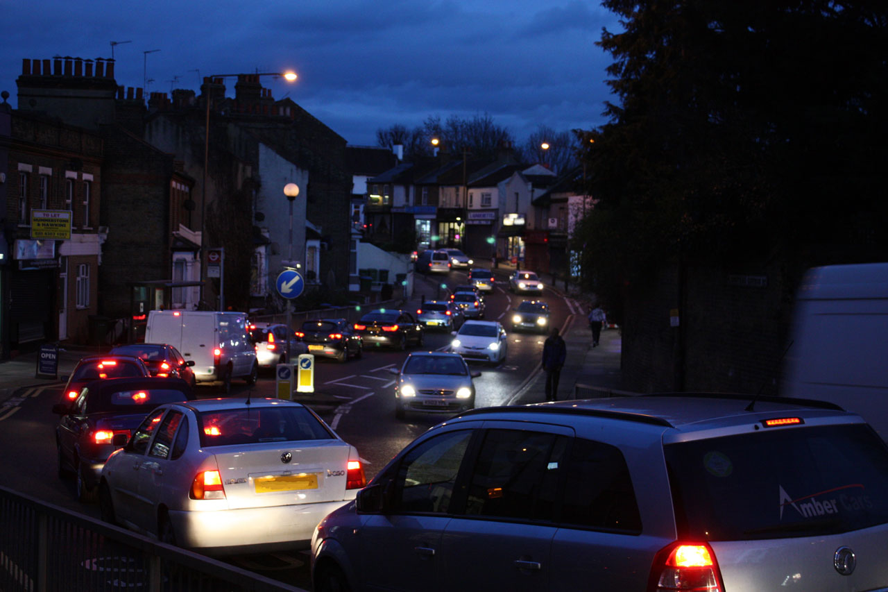
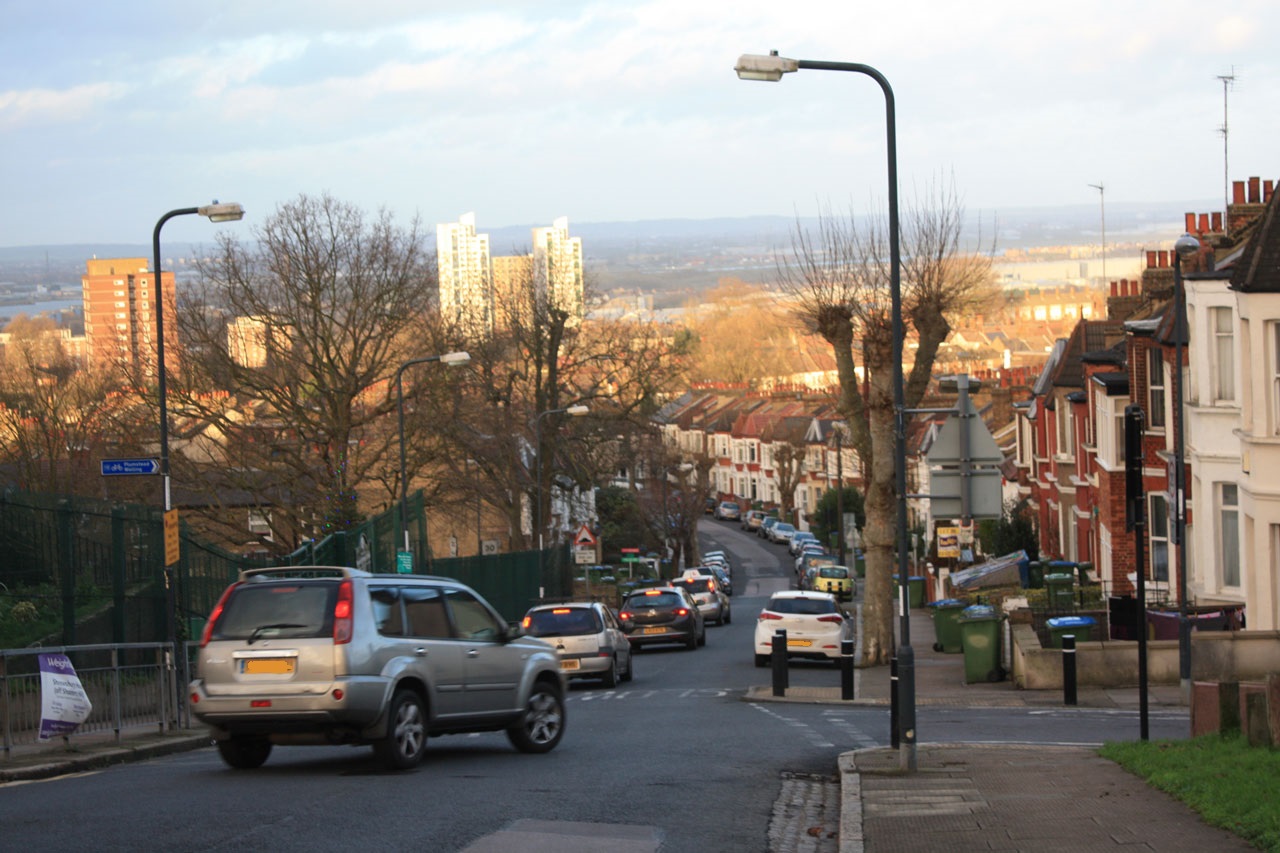
Evening rush-hour traffic on Plumstead Common Road
There are just a few days left to tell TfL our opinions about their proposed new river crossings at Gallions Reach and Belvedere: the consultation closes this Friday, 12th February. We can respond through an online survey with just 5 questions at:
We can also tell TfL what we think by email to rivercrossings@tfl.gov.uk or by writing to FREEPOST TfL CONSULTATIONS’.
It’s an opportunity to tell Transport for London of our concerns about the increased traffic congestion in our area that their own traffic models predict will come as a result of the new crossings: congestion that will lead to even more dangerous air pollution and the health problems that it causes. The excellent Bexley Against Road Crossings web site has many more suggestions about what to say to TfL.
No to Silvertown Tunnel pollution study results from 2014
The NO2 results map shows that the UK Air Quality Strategy and EU legislation 40 µg m³ limit for NO2 was exceeded at most measurement locations in Shooters Hill and Plumstead: at two sites along Plumstead Common Road and all sites along Shooters Hill and Shooters Hill Road. The cross roads at Shooters Hill Road and Academy Road, close to the Greenwich Free School and just down the hill from Christchurch Primary School had an NO2 level 162.5% of the limit. A similar level was detected down in Woolwich at the junction of John Wilson Street and Wellington Street, close to Mulgrave Primary School. The level near Greenslade Primary was only just below the limit. Children are particularly vulnerable to the health effects of NO2 from traffic pollution.
Upside Down Tube Map – with North/South reversal from not Geofftech.co.uk
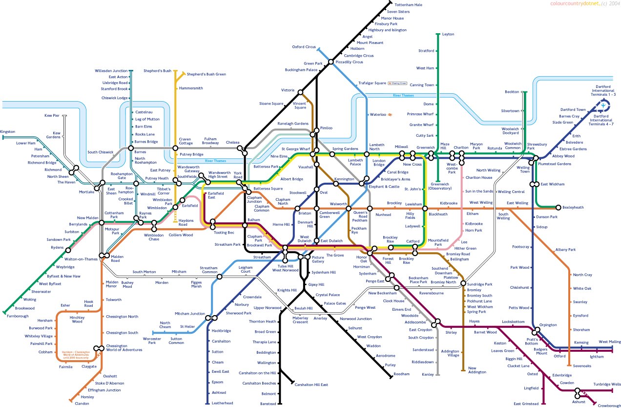
I’ve never really understood TfL’s argument justifying new crossings by the fact that there are many more road crossings to the west of tower bridge than to the east. It seems obvious to me that you would have fewer bridges closer to the sea because the river gets wider at it nears its estuary. A better comparison might be the difference in public transport, such as the tube, between north-west and south-east London. This is illustrated by the tube map variation from Geofftech, shown above, which reflects the tube map across to the south-east. If we were as well served as the other side of London we would have tube stations at the Rotunda, Woolwich Common, Shrewsbury Park and Plumstead Gardens, and the tube network would stretch as far as Tunbridge Wells.
TfL would have far more chance of reducing traffic congestion and pollution by improving our current very unreliable and overcrowded public transport and creating new public transport links than by building more roads which will attract more traffic. It’s well worth reading former Greenwich councillor Alex Grant’s very informative post: The supporters of new roads across the Thames are stuck in the past. Without rail links they’d be a disaster for east London for more on the history of east London river crossings, how other modern European cities have tackled the problem of congestion and the recurrent fears that a motorway will be built through Plumstead, Woodlands Farm and Oxleas Wood.
Transport for London seem determined to push ahead with their planned crossings: a recent e-mail from them said:
Last week Transport for London’s Board gave approval for us to submit a Development Consent Order to the Secretary of State for Transport for powers to implement the Silvertown Tunnel scheme. Our application will include a Consultation Report, which will set out our response to all of the issues raised in our recent consultation. We received more than 4,000 responses to the consultation and these are continuing to help inform our final plans.
We plan to submit an application for powers to implement the Silvertown Tunnel scheme in the spring 2016, and we will contact you again at this time once we are in a position to publish our Consultation Report.
If our application is accepted by the Secretary of State, there will be a public examination on the scheme managed by the Planning Inspectorate. In that case, you will have an opportunity to make written representations and take part in hearings as part of the examination. We will explain how you can take part in the examination when we write again, later this spring.
If you’re concerned about how these new crossings will affect traffic congestion and pollution in south-east London then you might like to attend the No to Silvertown Tunnel campaign’s annual general meeting which is at Mycenae House, Blackheath, on Thursday 18 February at 8pm. They ask that anyone planning to attend sign up at https://www.eventbrite.co.uk/e/no-to-silvertown-tunnel-agm-2016-tickets-21083026901
Oh, and complete the TfL East of Silvertown consultation before Friday.
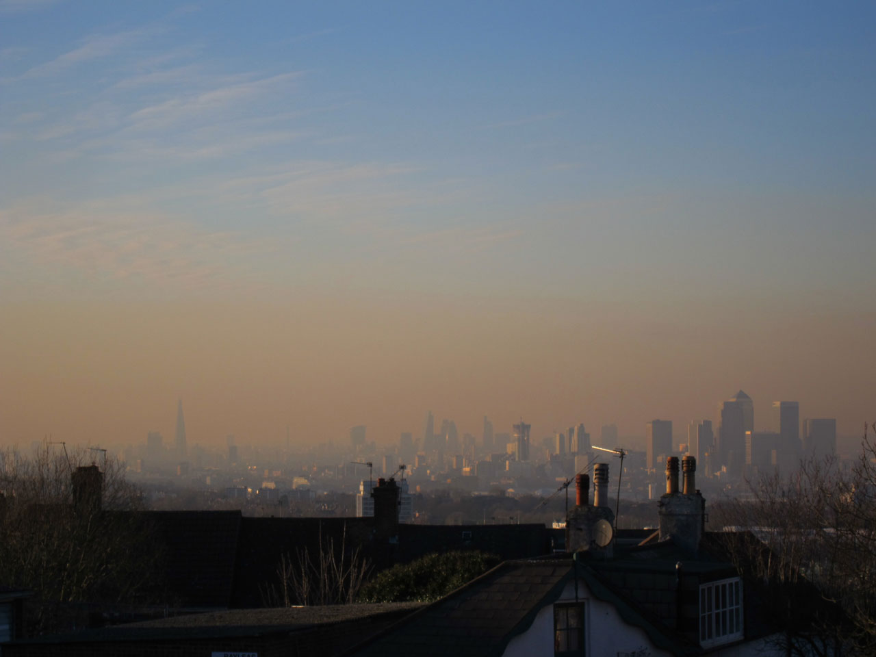
Orange fug over London at time of high air pollution
How will the proposed new East London river crossings affect traffic in Shooters Hill? This was the question I looked for answers to in the documentation accompanying Transport for London’s latest consultation on the crossings. As TfL have previously accepted that the road infrastructure south of the Thames is not adequate to serve the proposed new crossings this seems to be an essential question for them to answer.
The documentation includes a Traffic Impact Report: great, I thought, that’s where I’ll find the answer, but no, it turned out to be far more complicated to find what I was looking for.
The first complication is that the report assumes that the proposed Silvertown Tunnel has already been built. It doesn’t explicitly say so: it models the traffic effect of the new crossings compared with a Reference Case, which “reflects the highway network in 2031”. Reading through it quickly becomes clear that the traffic flow changes calculated are the effect of adding the Gallions and Belvedere crossings to a road system which includes the Silvertown Tunnel. Not the change from today’s traffic flows to those after the proposed crossings are developed.
No problem: there was a Silvertown Tunnel consultation recently, which included amongst its archive documents a Traffic Forecasting Report from 2014. This should let me see the changes to traffic as a consequence of the Silvertown Tunnel, I thought, which I can combine with the latest report to see what the total impact of all the proposed new crossings will be.
But again no. The Silvertown report also assumes a reference case which is the traffic in 2021. Why? They don’t seem to say. This reference case is defined as:
Reference case (2021)
6. The reference case represents 2021, and includes growth in population and employment from the 2009 London Plan. Population is expected to increase more rapidly in east and south east London than in other sub-regions.
7. The reference case also includes committed transport schemes. Public transport connectivity across east and southeast London improves because of planned investment including Crossrail. The Woolwich Ferry is assumed to have been enhanced with 30% additional capacity. The reference case does not include the Silvertown Tunnel.
8. From 2012 to 2021 the proportion of travel by car is expected to fall in Greenwich, Newham and Tower Hamlets, but the growth in population and employment result in an increase in total car trips.
Why they think the Woolwich Ferry will have 30% more capacity is also unclear – a footnote in the report just says that “by 2031 Woolwich Ferry would need to either be upgraded at its existing location or replaced with a new crossing”. This upgrade is not a “committed transport scheme” as implied by the extract above. They also assume that the Woolwich Free Ferry will be charged, as would the Blackwall, Silvertown, Gallions Reach and Belvedere Crossings. The charges would be the same as for the Dartford Tunnel at peak times and half that rate at other times. TfL assert that these charges will counteract the “induced traffic effect” where new roads generate new traffic. However their rationale for this assertion is unconvincing and they say it “… is not modelled in the Assessed Case.”
The Silvertown Traffic Forecasting Report also considers in Appendix C the impact of the Gallions and Belvedere crossings on traffic flows. Interestingly it ends up with different results to those presented in the Gallions/Belvedere consultation Traffic Impact Report.
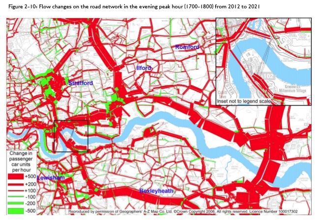
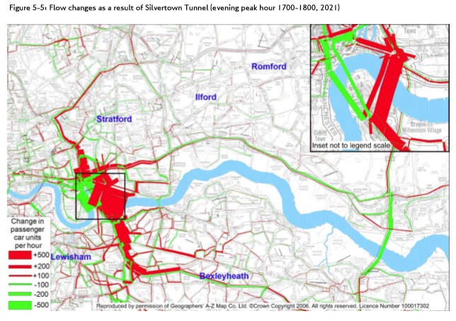
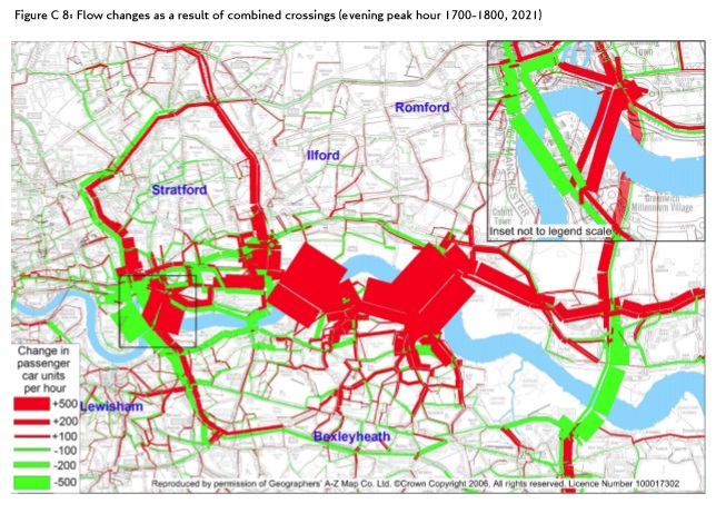
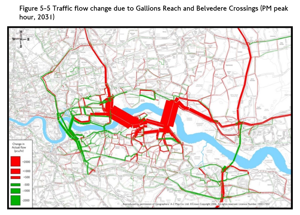
The reports contain a large number of tables, graphs and maps of the traffic modelling results. I’ve extracted four maps to try to give a flavour of the impact of the crossings on our local streets. All four are for the afternoon rush hour traffic:
The 2021 “Reference Case” from the Silvertown Tunnel Report;
The impact of the Silvertown Tunnel compared to the reference case from the Silvertown Tunnel Report;
The impact of the Gallions Reach and Belvedere crossings compared to the reference case and Silvertown Tunel from the Silvertown Tunnel Report;
The impact of the Gallions Reach and Belvedere crossings compared to the reference case from the Gallions/Belvedere Report.
Red on these maps indicates increased traffic flows and green reduced.
Reference case afternoon peak traffic flow increases from Silvertown Tunnel Traffic Impact Report
Post-Silvertown Tunnel and East London crossings afternoon peak traffic flow increases from Silvertown Tunnel Traffic Impact Report
Afternoon peak traffic flow increases from Gallions Reach and Belvedere Traffic Impact Report
The scale and resolution of the maps make it difficult to work out which local roads suffer traffic increases, but it’s just about possible by zooming in and looking at the shape and orientation of the roads. The red/green bar method of showing traffic changes also tends to obscure rather than illuminate. Anyway, here’s my interpretation of what the modelling is showing.
The reference case, which just reflects population growth and an increase in Woolwich Ferry capacity, already has big increases – 100 cars per hour or more – along Shooters Hill Road, Shrewsbury Lane, Plum Lane and slightly surprisingly Donaldson Road too. The increase along Plumstead Common Road looks even bigger, and also along Kings Highway, Wickham Lane down towards Knee Hill.
Bringing the Silvertown Tunnel into the model there is a decrease in traffic flow along Shrewsbury Lane and Plum Lane, but an increase in Red Lion Lane which runs in a similar direction. Along Shooters Hill and Shooters Hill Road traffic flows increase again, and the route down through Charlton to the tunnel has more traffic, affecting Baker Road and Stadium Road past the hospital then Charlton Park Lane and Cemetery Lane.
In the Silvertown Tunnel report the impact of the additional crossings at Gallions Reach and Belvedere is a very slight reduction of traffic along Shrewsbury Lane, but an increase along Eaglesfield Road to Plum Lane which is unexpected (and unlikely I would have thought), and an increase in Plum Lane itself. Not unexpected are the additional increases in Plumstead Common Road and the route down to the High Street via Griffin Road, nor those from Plumstead Common down Kings Highway to Wickham Lane and Basildon Road and Eynsham Drive. There is lots of red showing big increases from the A2 over towards Gallions Reach and Belvedere, affecting Upper Wickham Lane, Lodge Hill, Okehampton Crescent, Brampton Road and Knee Hill (yet again).
It also predicts that traffic going along the bottom of Herbert Road, through the shops will increase. Can you imagine even more cars trying to negotiate the hazardous route between parked vans and oncoming buses in the rush hour?
The final map, from the current consultation, is similar to the previous one but now there is an increase in traffic along both Shrewsbury Lane and Eaglesfield Road. Other flows appear to be increasing less than in the Silvertown report. In the Gallions Reach/Belvedere report TfL admit to using an earlier version of the traffic model than in the Silvertown report, but don’t really explain why.
The striking feature of all of these maps is the amount of red on them, showing cumulative increases in traffic flows as each crossing is built.
The traffic modelling doesn’t seem to take account of how the roads actually are. For example, that nice straight red line showing increased traffic from Shooters Hill along Shrewsbury Lane and Plum Lane through to Plumstead Common Road. These are residential roads, not suitable to be used as a through route, with speed bumps, and a 20mph limit along Plum Lane. Very often the traffic is single file due to parking on either side of the road. Plum Lane passes close by Plumcroft Primary School. And at the bottom there’s that narrow one way stretch of Plum Lane, making traffic going down the hill turn left and then right along Kirk Lane to get through to Plumstead Common Road. The very sharp turning between Plum Lane and Plumstead Common Road doesn’t exist as far as TfL are concerned.
Similar points could be made about many of the other roads showing increased congestion on TfL’s maps. There are campaigns in Plumstead and Bexley to oppose the crossings, largely because of the devastating impacts on local residential roads.
The main effect of breathing in raised levels of nitrogen dioxide is the increased likelihood of respiratory problems. Nitrogen dioxide inflames the lining of the lungs, and it can reduce immunity to lung infections. This can cause problems such as wheezing, coughing, colds, flu and bronchitis.
Increased levels of nitrogen dioxide can have significant impacts on people with asthma because it can cause more frequent and more intense attacks. Children with asthma and older people with heart disease are most at risk.
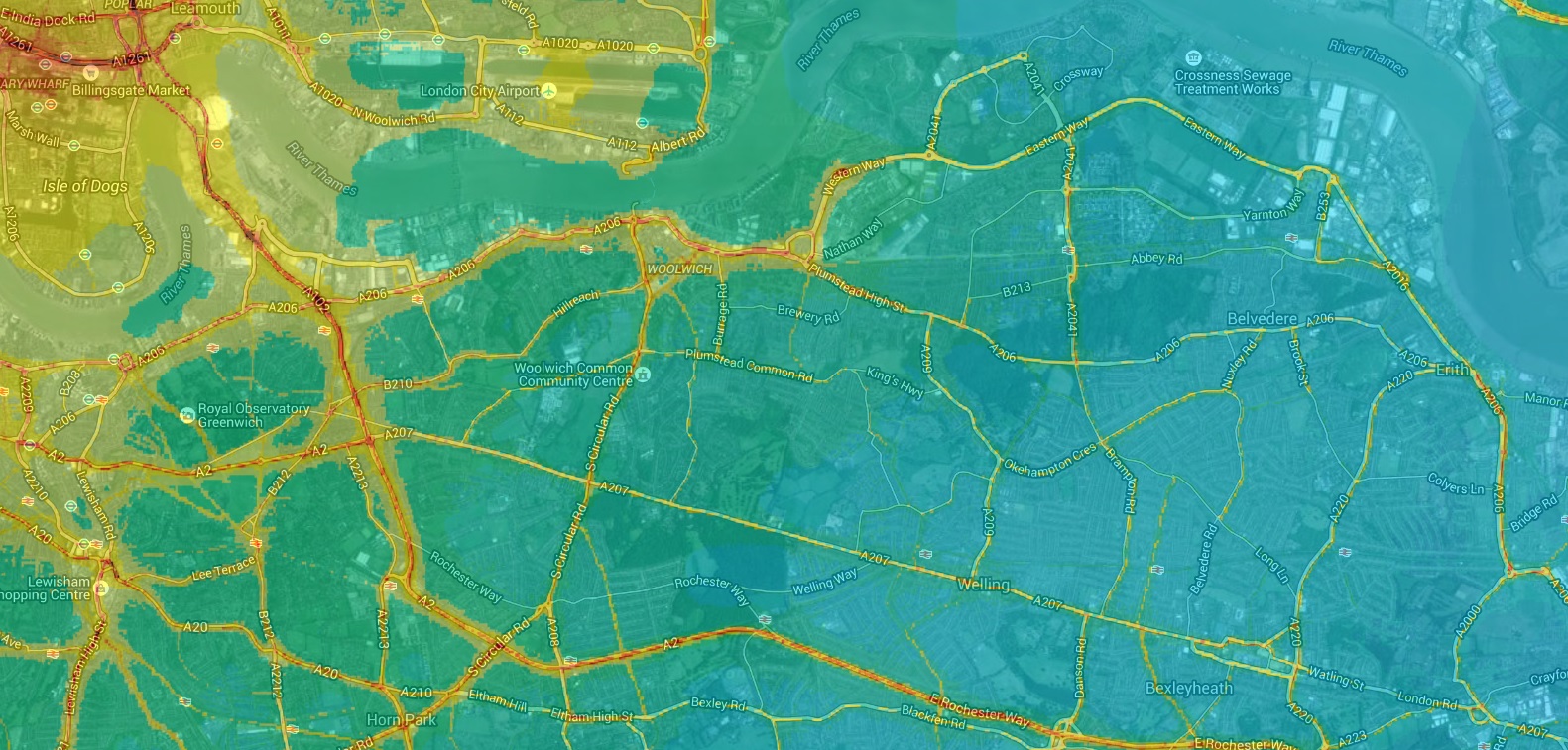
The UK Air Quality Strategy and EU legislation both set an annual average limit for NO2 of 40 µg m-³. In London in 2013 only two local authorities met the limit for NO2, and Greenwich wasn’t one of them. Kings College’s London Air web site has mapped 2010 NO2 levels across London: I’ve included a snippet showing Shooters Hill below. The 40 µg m-³ is shown in yellow on the map, with higher concentrations in deeper shades of orange and red. As well as the major roads, there are high levels along Shrewsbury Lane and down Eglinton Hill, Sandy Hill Road, Burrage Road, Plumstead Common Road and Swingate Lane.
Modelled annual mean NO2 air pollution, based on measurements made during 2010 from London Air web site
We have until Friday 12th February to respond to this latest consultation. The main themes of this consultation are whether it would be better to build a bridge or dig a tunnel at the two locations, and about how public transport might link to them. We can respond through an online survey, by email to rivercrossings@tfl.gov.uk or by writing to FREEPOST TfL CONSULTATIONS’.
As I’ve said before in posts about a previous consultation and about Oxleas Wood TfL need to say how they will solve the inadequacies of the transport network south of the Thames and demonstrate that new crossings will not cause congestion and pollution in residential roads. Otherwise people will think that they are cynically conspiring to cause chaos and compromise air quality in south-east London so as to be able to justify a new motorway from the A2 to the river through Oxleas Wood, Woodlands Farm and hundreds of Plumstead homes.
Transport for London are continuing with their plans to build a new bridge at Gallions Reach, but it’s the beginning of the end for the Woolwich Free Ferry following the results of the consultation into new river crossings east of the Blackwall Tunnel. TfL’s e-mail about the results said:
The majority of feedback supported the introduction of new fixed link crossings, rather than enhancement of existing or introduction of new ferry crossings. Having considered all of the issues raised in the consultation, we will now continue to develop the concepts of new bridges at Gallions Reach and Belvedere, and we will also consider whether tunnels would be more suitable by releasing greater land for development than would be possible with a bridge.
and:
We will put our consideration of proposals for a new ferry at Woolwich and a ferry at Gallions Reach on hold, pending the outcome of this work.
65% of respondents to the consultation “strongly supported” the Gallions Reach bridge option and a further 15% “supported” it (80% total support), as you can see in TfL’s summary of the results below. In comparison the figures for improving the Woolwich Free Ferry were 19% and 18% respectively (37% total support). Opinion has hardened in favour of a Gallions Reach bridge and against the Free Ferry since the previous consultation in 2013: a Gallions bridge or tunnel had the support of 71% and the Free Ferry 51% in that consultation.
The Consultation Report gives all the results and presents a selection of the comments made by the public about each of the options. Strangely it manages to find no comments in favour of the Woolwich Ferry option and a page and a half against. You would almost think that TfL were trying to present a particular point of view rather than impartially report on the results.
In the image at the top the new Gallions Reach bridge would cross the river roughly in the centre of the photo, this side of the Barking Creek tidal barrier – the high structure just to the right of centre, on the river. The bridge would be higher than the Barking barrier.
Summary of support for different options from TfL Consultation Report
The proposal for a new tunnel at Silvertown was not included in this consultation, in fact it is assumed in all the supporting documents that the Silvertown Tunnel will have been built by the time any of the consultation options are constructed. Additional traffic capacity at Silvertown is the main plank of TfL’s defence against the charge that the road infrastructure south of the river is inadequate for the expected traffic going to the new crossing at Gallions Reach.
As well as the Consultation Report, TfL have published a Response to the Issues Raised document which gives TfL’s opinion on specific objections raised about the different crossing options. It has sections on concerns about increased traffic and congestion, and about the threat to Oxleas Wood.
They have two responses on traffic increase and congestion: Paraphrasing, firstly they say they warned us that there would be more traffic on some roads, but they don’t know which roads will be affected. Part of their work in the next stage will be to work out what impact a Gallions Reach Bridge will have on traffic flow and what they can do about it. The second response is that they think most non-local traffic will use the tunnels at Blackwall and Silvertown and not the new bridge because the tunnels have better links on the other side of the river.
Doesn’t exactly fill me with confidence that they’ve thought this through, and there is an implicit assumption that the crossing will go ahead and any problems will be “mitigated”: even if the future work shows that Plumstead will be gridlocked with traffic that will not stop the crossing’s construction. An almost identical response is given to concerns about the environmental impact: we’ll do some more work to understand the impact and how it can be “mitigated”.
TfL’s response on concerns about the threat to Oxleas Wood points out the differences between the current proposals and earlier schemes such as the East London River Crossing. In particular they say:
It is not the intent that the new crossings will provide a new strategic route for traffic with no local origin or destination, and it is not intended to carry traffic between the A2 and the North Circular, a journey which would remain more convenient via the Blackwall tunnel.
What does “local” mean in this context? TfL don’t say.
The response also mentions that the Gallions Reach Bridge would be one of three new crossings, with the Silvertown Tunnel and Belvedere Bridge, so the traffic load would be spread, and it asserts that tolling the crossings will allow TfL to manage how much traffic uses them.
Some of the details given about the new bridge are interesting. It will have two lanes of traffic, but one will be reserved for public transport and HGVs. There will be provision for pedestrians and cyclists to use the bridge, and they are considering whether it should carry the DLR over the river to Thamesmead and Abbey Wood.
As well as traffic and environmental impact assessments, TfL’s next steps include considering “whether we might need to take additional traffic management or other mitigation steps to ensure the new crossings operate successfully and sustainably” and “how we can make best advantage of the opportunities that new river crossings would give us to improve cross-river links for pedestrians, cyclists and public transport passengers”. They don’t say when the next stage will be complete.
Whatever emerges from the next steps the future doesn’t look good for the Woolwich Free Ferry.
The Falconwood Hotel (photograph from Greenwich Heritage Centre)
It’s hard to believe now that the little track running into Oxleas Wood from Shooters Hill was once the drive way to the Portland-stone Palladian mansion shown in the photograph above from Greenwich Heritage Centre. It was the home of Lords and Barons, painted by society artists and also once a hotel with 20 bedrooms. It was as grand inside as out, as shown in the set of photographs in the London Metropolitan Archive. These were taken in 1955 not that long before its demolition, and depict its elegant drawing rooms and a magnificent double-branched curved staircase as well as the boarded up exterior.
The site of Falconwood is today a butterfly-filled meadow surrounded by Oxleas Woods.
When the mansion was built in 1864-67 by the 2nd Lord Truro, Charles Robert Wilde, it was called Falconhurst. Lord Truro was related to Sir James Plaisted Wilde, who became Lord Penzance, and lived nearby at Jackwood. In the London Metropolitan Archive there is a typed sheet of reminiscences by Major C.E.S Phillips of Castle House about Falconwood. He has this to say about Lord Truro:
Falconwood was built by Lord Truro, reputed an illegitimate son of George IV. It is on Crown Land and was granted to him free of ground rent. Lord Truro had lived much in Italy and built Falconwood in purely Italian style. When his wife died (about 1880) she was buried under the lawn at mid-night by Lord Truro and his gardener Mr. Hart. The grave was surrounded by some beautiful wrought iron work, but after Lord Truro’s death in Italy this was removed and nobody knows now exactly where the grave is.
Lord Truro left the place and a strip of freehold land on the other side of the road to a very beautiful lady of limited virtue. They were a magnificent pair on horseback, both perfect riders. The legacy proved a nightmare for the legatee, for as soon as the Earl died, the Crown Office afixed a ground rent of £400 per annum on the property and she had no means of paying it. It was put up to auction but the first time there was not a bid for it. On the second auction it was bought by Sir Clarence Smith for I think £5000. It has cost £50,000.
I am indebted to our old Mr. Hart for the matter of the 1st part of this, it was he who helped bury Lady Truro, for all the rest I have relied on my memory only as I was familiar with all the facts at the time.
David Lloyd Bathe’s “Steeped In History” gives more details of the story: it reprints an article from the Daily Telegraph from 17th October 1879 which says that Lord Truro used a light coffin so as to “not arrest the process of natural decay”, and that the burial spot was chosen by Lady Truro. It also says that they understood that the Lady’s remains were later removed by her relatives. The burial in non-consecrated ground shocked the neighbourhood, and one resident said they could smell the emanation of sulphurous gases.
“Steeped In History” details the subsequent occupancy of the mansion. After Hull MP Clarence Smith moved out in 1908 he was unable to find a purchaser and the lease reverted to the crown. It was then let to Catherine (Kate) Rose Marie Antoinette d’Erlanger (née de Robert d’ Aqueria de Rochegude), wife of Baron Emile Beaumont d’Erlanger. Baroness d’Erlanger was known as “the Flame” because of the colour of her hair, and was renowned for her lavish entertaining. She was very well connected, as Philip Mershon says:
Catherine cultivated the most astonishingly irreverent continental society of bohemians, artists and aristocrats at salons in her homes. She was pals with Ravel, Debussy, Nijinsky and Proust. She was also financial patroness to Diaghilev, The Ballet Russe de Monte Carlo and Cecil Beaton.
Catherine herself was photographed by Cecil Beaton, and also by Lafayette Ltd in the picture below from the National Portrait Gallery. It shows her in a “tableau vivant”, which was part of an entertainment called The Masque of War and Peace held in aid of the Widows and Orphans of the Household Troops during the Boer War.
Enid, turning her ‘ardent snobbish eyes, mad with interest’ on the beau monde, soon wandered through a hole in the hedge. Announcing her credentials boldly, she told the Baroness she was a journalist poised to write books. She knew that her inadequate clothes and schoolgirl fresh face were not enough. ‘Whatever I have looked like, and what my face has not carried, I have always had a sort of vitality that did instead’. She managed to put herself over. But the d’Erlangers were installing a hard tennis court and Enid’s immediate entry ticket was her facility with a tennis racket. She quickly became a daughter of the household.
The d’Erlangers left Falconwood at the time of the First World War. In June 1924 the Baroness applied to the London County Council for a licence to hold music and dancing entertainments in the drawing room on Falconwood’s ground floor. The licence committee notes in the London Metropolitan Archive say that it was proposed to use Falconwood as a private hotel. In 1932 the Baroness surrendered the lease and later moved to Hollywood.
Falconwood continued as a hotel under new management. In the archives there are Music and Dancing licence applications from Walter Frank Mills in 1933, Frederick Henry Clark in 1934 and F. Hugh Gough in 1936. The hotel seems to have continued in operation until after the war, but eventually failed. According to E.F.E. Jefferson’s “The Woolwich Story” Falconwood was acquired by Woolwich Borough Council in 1936 and was “laid out” in the 1950s and incorporated into Oxleas Wood. The house itself was demolished in 1959.
Falconwood Bexley. This district was developed in the 1930s as Falconwood Park on the site of a large wood called West Wood on the Ordinance Survey maps of 1805 and 1876 (earlier Westwood 1551). It is said to have been given this name to attract new residents.
So West Wood – the wood at the west end of the Manor of Bexley – was the name of the district, and of the farm there, until Ideal Homesteadsbuilt Falconwood Park in the 1930’s, Maybe the company was inspired by the history up the hill when naming its new estate.
As for the site of the mansion it is now a peaceful butterfly-filled meadow only occasionally enlivened by walkers and dogs.
Site of the former Falconwood Hotel
Common Blue butterfly at site of former Falconwood Hotel
Meadow Brown butterfly at site of former Falconwood Hotel