Ye who have a spark in your veins of cockney spirit, smile or mourn acccording as you take things well or ill;— Bold Britons, we are now on Shooter's Hill!
Mtr. Ariadne van den Hof, the Vicar of Christ Church Shooters Hill and Chair of Premises at Christ Church School, e-mailed to say that the MUGA (Multi-Use Games Area) behind the School is now open for members of the public to use outside school hours. That means that it can be used after 5pm Monday -Thursday, after 4pm Fridays and all day Saturday and Sunday. Access to the area is through a gate at the end of the new path to the left of the school.
This fulfils the agreement made between the school and the Royal Borough of Greenwich when planning permission was granted to extend the school and create a new play area on Eltham Common.
The MUGA has line markings for a variety of different sports, and there is also a permanently marked hop-scotch court! What luxury, when I was at school we had to use chalk.
Mayplace Lane near the bronze age barrow on Plum Lane
If you’re interested in helping to tidy and improve Mayplace Lane, or want to know more about proposals to prevent fly-tipping in the lane, then come along on Sunday (3rd November) at 11.00am to meet others with similar interests. Nicola sent a reminder on twitter about the get-together:
As well as clearing litter there are suggestions that lovers of the lane could also improve it by guerrilla gardening and encouraging nature, for example by building woodpiles for hedgehogs and erecting nesting boxes. Perhaps a Neighbourhood Watch group could be set up. I’m sure these ideas will be discussed on Sunday, along with proposals to put lockable gates at each end of the lane to stop fly tipping trucks from dumping their loads of rubbish.
The gating suggestion was set out in a meeting at the Town Hall on the 19th September attended by Paul Stephen, the Community Safety Officer and Partnership Coordinator in Greenwich Council’s Safer Communities Team, Martin Ryan from CleanSweep, local councillor Danny Thorpe and a few local residents. There would need to be gates at the Plum Lane junction and just above Highview flats down near Dallin Road, and a “Friends of Mayplace Lane” group would need to be established to take responsibility for the lane after the gates had been installed. It was stated that because the lane is unadopted the council had no legal responsibility to clear fly-tipped rubbish, though they have been doing this up to now, and if gates were installed it was expected that the Friends would be responsible. Details of how the scheme would work, such as exactly what gates would be used and who would be given keys for the gates, were left for later clarification.
Before gates can be put up the council will need to get a “gating order”, for which they have to follow a process which includes a full consultation of affected people. To decide whether it was worth starting on this process an informal door-to-door poll was conducted one Saturday morning at houses in Eglinton Hill and Brinklow Crescent which back on to Mayplace Lane. The result, according to an e-mail from Councillor Danny Thorpe, was: “We have 39 responses in total, with 37 in favour and two against or not interested.” This was enough for the council to start on the gating order process. I haven’t heard yet how it’s progressing.
Snippet from1837 map in the Firepower Museum
I think Mayplace Lane is fascinating, and love the idea that perhaps it was once a route that Bronze Age people used to visit the land of their ancestors – the barrow cemetery that once adorned the top of Shooters Hill. I had read that it was an old track that predated the modern road layout, and found confirmation serendipitously at the Firepower museum‘s recent community open day. A map of Woolwich and environs from 1837 on the wall at Firepower includes an intriguing path from the top of Sandy Hill Road up to the summit of Shooters Hill. You can see it on the snippet above labelled “To Shewsbury House”. It starts just over the road from the Fox and Hounds; a pub of that name is still there today.
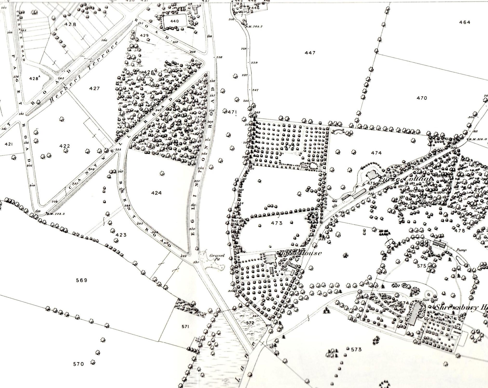
Why do I think that path is Mayplace Lane? Well its northern end is in about the same place – continuing the line of Sandy Hill Road, roughly where Herbert Road is today. But also, in the 1866 OS map from Alan Godfrey shown in my earlier post about Mayplace Lane you can see that Mayplace Lane ends up close to the start of the old Shrewsbury House’s long drive way, which was roughly where the fire station is now. I’ve included the 1866 snippet again below, rotated through 180° so that South is at the top as in the 1837 map. Mayplace Lane winds up the centre of the map. Interesting that in the 29 years between the 1837 and 1866 maps some modern roads such as Eglinton Hill have been constructed – the start of the development of the Herbert Estate by British Land.
Snippet from 1866 OS Map rotated so South is at the top
Another thing that’s been puzzling me about Mayplace Lane, possibly related to gates, is the strange concrete blocks in the ground just past the Bronze Age barrow. You can see them in the photograph below – two rows of three square concrete objects a couple of yards apart. Each piece of concrete has a distinct, separate circle at its centre, as though there was a concrete post which has been cut off level with the ground. Does anyone know what they are or were? There’s nothing on the old OS maps to indicate that there was a gate or barrier at this location, and they look more 20th century than 19th. I wonder if they could be something to do with second world war defence preparations. There were other defensive structures nearby – for example Dragon’s teeth were set up in Eglinton Hill and Brinklow Crescent to impede movements of tanks and mechanised infantry. I’d love to know – but it’ll have to be another topic for my next visit to the Greenwich Heritage Centre.
We are not the only Shooters Hill in the world, though we may be the oldest. When researching local issues I’ve often come across other Shooters Hills, frequently finding that foreign namesakes have similarities to our own. Also our @shootershillbot, which scans twitter and elsewhere for mentions of Shooters Hill, often re-tweets information about other Shooters Hills that could be confused with local events.
There are extra Shooters Hills in the UK near Stoke on Trent in Staffordshire, at Pangbourne in Berkshire and in Cowes on the Isle of Wight. Overseas there are Shooters Hills in Jamaica and Australia, not to mention the site of the George Washington Masonic National Memorial in the USA.
Concerns here about the health effects of mobile phone masts are shared by residents of the Shooters Hill in Stafford, who have a long-standing campaign against the mast in their midst. They believe their Shooters Hill mast is the cause of seven deaths and twenty illnesses, as the Mail Online reported:
Since then there has been seven deaths and 20 illnesses, which locals claim is linked to the towering structure dominating the skyline.
Four people, including neighbours Elsie Jones, Yvonne Greensmith and Freda Oakes, have died from brain haemorrhages, all within three years of each other.
Three other residents have succumbed to cancer, among them John Cornes and John Butler, who died from a brain tumour.
Four non-fatal cases of cancer have been reported, as well as three people suffering irregular heartbeats, five who have constant headaches and sleeplessness and six who have high blood pressure.
Two have also complained that their epilepsy has worsened significantly in the last ten years. The three worst affected streets are Cherrywood Grove, Sandon Road and Milward Grove, which are all just yards from the mast.
Stoke-on-Trent City Council commissioned expert tests last year to find anything that would have a negative effect on human health but they found nothing.
The campaign against the Staffordshire Shooters Hill mast has been supported by local MP Robert Flello, who raised it in a parliamentary debate on the mobile telecommunications and health research programme in 2007, and local councillor Abi Brown. They haven’t (yet) succeeded in getting the mast removed, though they have prevented a second mast being erected.
The Shooters Hill in Pangbourne is a pretty road running alongside the Thames in Berkshire – a much narrower Thames there than the one we have views of. As well as the Thames connection to our Shooters Hill, it also has evidence of Roman occupation, “including many gold and silver coins and a number of skeletons”, according to the Royal Berkshire History web site, and was close to a Roman Road. There are three listed buildings on the Pangbourne Shooters Hill, two of which are part of a group of houses sometimes known as “The Seven Deadly Sins”. One of them, number 47, is in the same Queen Anne Revival style as the farmhouse at Woodlands Farm.
George Washington Masonic National Memorial by Joe Ravi (license CC-BY-SA 3.0)
The Pangbourne Shooters Hill also has a Masonic Hall, though it looks more modest than the 333ft high George Washington Masonic National Memorial on the top of Shooters Hill in Alexandria, Virginia, near Washington, D.C. There is a debate about how the masonic Shooters Hill got its name which is very similar to the different ideas about the etymology of our own Shooters Hill, as the DC Pages web site says:
Some claim that it derives its name from the fact that it was once home to two forts during the Civil War era. From this vantage point, Union soldiers or “Shooters” could protect the approaches to Alexandria and Washington, DC against the possible attacking Confederate forces. Others claim that the hill was originally called “Shuter’s Hill, after an early resident of Alexandria.
Shooter’s Hill is named for the Shooter’s Hill area of South London. The Smith family, which owned Shooter’s Hill, came from the Shooter’s Hill area of London and claim descent from the explorer Captain John Smith. See: Smedes, p. 12; “Smith, William Morgan, M.D.”, p. 555-556. However, some archeologists believe the name was derived from the last name of an inhabitant in the 1740s. See: Allen, Mike. “City’s Hill Holds 5,000 Years of History.” Washington Post. May 22, 1997.
The Australian and Jamaican Shooters Hills sometimes turn up in tweets that may be confused with local events, for example traffic problems in the Jamaican Shooters Hill and snow reports in the New South Wales one. Shooters Hill in Australia must be the highest: at 1355m it’s over ten times the 129m height of our hill. Shooters Hill in Jamaica is renowned for being the home of Pickapeppa Sauce, sometimes described as “Jamaican ketchup”. It is also the site of Captain Heron’s tomb.
Finally, an addition to the Ghosts of Shooters Hill, though this time in a Shooters Hill in Cowes on the Isle of Wight. This tiny, touristy street is shown on Ghost Island‘s spooky ghost map of Cowes, because it is haunted:
A little ghost named Ursula haunts properties in Shooters Hill. At one, the spirit of a young girl with straight blonde hair was often seen by the owners who even bought a Ouija board to find out why she was haunting them. Lala, as she likes to be called, wears a black Victorian dress, a long white pinafore trimmed in broderie anglais and little black boots. Lala is aware she has died, but doesn’t want to ‘move on’.
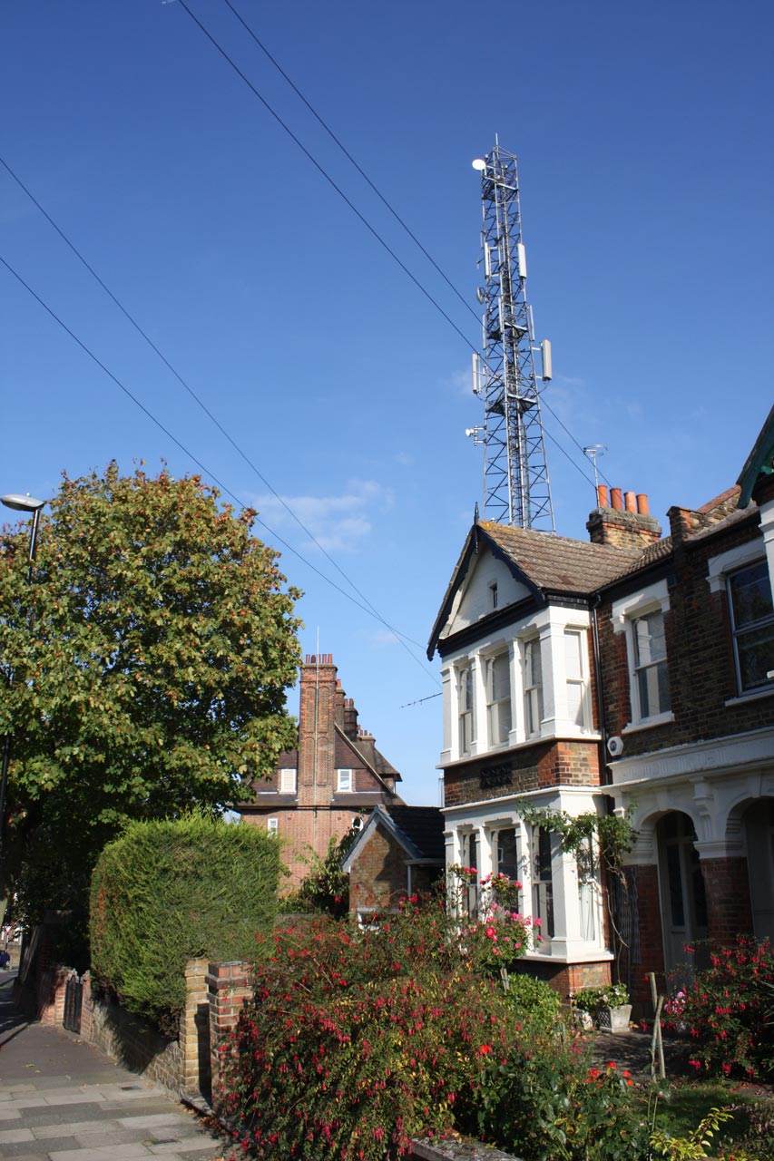
Shooters Hill Fire Station Mast from Eaglesfield Road
Will the new 4G mobile phone system interfere with our Freeview TV reception? We may find out next week when a test is being run in south-east London, including parts of Greenwich. A company called at800, a brand name for Digital Mobile Spectrum Limited (DMSL), is running the tests. Their press release said:
A test to help understand the extent to which 4G at 800 MHz may disrupt Freeview is being run in south east London. at800 is asking viewers in the area to report problems with television reception from Monday 15 April. at800 is the organisation tasked with ensuring viewers continue to receive Freeview when 4G mobile services at 800 MHz are launched later this year.
Approximately 170,000 household and business addresses in parts of Greenwich, Lewisham, Southwark and Tower Hamlets are being contacted directly to alert them to the test. This larger-scale testing follows an initial small-scale test in the West Midlands.
Households that at800 think will be affected will be sent a postcard like the one below in the next few days.
at800 specimen postcard
The new 4G mobile broadband will use the 800MHz frequency band that used to be used for analogue TV. This is close to the 700MHz that Freeview uses. An article by Barry Fox in April’s edition of Everyday Practical Electronics explained:
The 800MHz 4G band is very close to the 700MHz band frequencies used by Freeview. Co-channel interference is inevitable, especially for homes close to a 4G base station and where aerial amplifiers are used. Interference may well be variable and intermittent, making it harder to tie cause to effect.
It was estimated by Ofcom that that the problem could affect up to 2.3million homes, but in an initial pilot study covering 22,000 homes in the Midlands only 15 homes suffered interference.
If you suffer TV interference next week, at800 have a number for you to call:
If you live in the south east London area and notice problems with your Freeview service from 15 April, please contact at800 by calling 0333 31 31 800. You will be asked for your postcode, the type of interference and the time it occurred. This will allow at800 to restore your service as soon as possible. Freeview is the television that viewers receive through their aerial.
Most cases of interference can be solved by fitting a filter between the TV and aerial, and at800 will provide one filter to each affected household. The at800 website has details of what needs to be done in different situations, and of the support that will be provided. In the worst case, where a filter doesn’t solve the problem then at800 will provide an alternative such as Freesat or cable at a cost of up to £10,000.
Cable and Satellite TV will not be affected by the 4G signal, only over the air, digital terrestrial television, to aerials.
Mayplace Lane may at first sight seem like a typical back alleyway running to the garages behind houses in Eglinton Hill, but it’s much more than that. As you can see in the snippet from Alan Godfrey‘s 1866 OS Map of Shooters Hill it was there before the houses in Eglinton Hill were built, winding down behind Tower House parallelling Eglinton Hill. The Lane is thought to be part of a track that went all the way down to the Woolwich Marshes, following the line of Sandy Hill Road. According to the Survey of London Volume 48 on Woolwich, Sandy Hill Road itself “was laid out along the line of a footpath that rose diagonally through what had been called Hilly Field”. So it seems that before the roads we now know were laid out Mayplace Lane ran from the Bronze Age barrow in Plum Lane all the way to the marshes that once bordered the Thames.
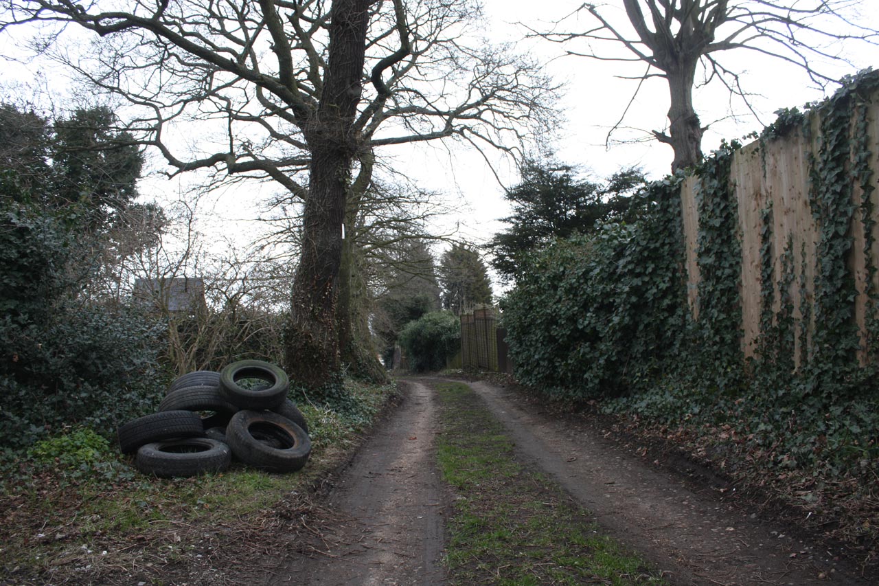
Mayplace Lane with Fly-tipped Tyres
Mayplace Lane is also, in places, a pretty and secluded path, providing a pleasant alternative route down the hill towards Woolwich, though it is a bit uneven in places especially around High View flats where it shares the hill with a permanent water flow of what appears to be spring. Well it would be pretty if it weren’t for the persistent fly tipping which has blighted the lane for years. This isn’t just the usual dumped mattresses, but lorry-loads of old tyres, building remains and, at the moment what looks like corrugated asbestos roofing sheets.,
In the past the Royal Borough of Greenwich Clean Sweep team have removed fly-tipped rubbish, though they maintain that they don’t have to because Mayplace Lane is an unadopted road. Frustratingly the current piles of rubbish have been there for some time and consequently are being scattered over a wider area. A twitter exchange about the rubbish last week has led to e-mails being sent to our local councillors, MP Clive Efford and London Assembly Member Darren Johnson to try to get some action.
One suggestion, which I thought was a good idea, from @Twinsclubplus was that we should have a “Friends of Mayplace Lane”, which I guess would be a bit like the “Friends” groups that look after local parks. It could keep an eye out for fly-tippers, make sure any tipping was reported promptly, perhaps help clear up the Lane and lobby towards getting a more permanent solution to the problem such as a lockable gate up at the Plum Lane end.
Please let me know if you’re interested in being involved with a “Friends of Mayplace Lane” group on the usual e-mail hilly@e-shootershill.co.uk.
Of course fly tipping is not confined to Mayplace Lane: it’s a borough-wide problem which has been going on for years. In the past the local neighbourhood watch and the 853 blog have both explained what to do about it, but here’s a reminder.
Make a note of as much information about the fly-tipped waste as possible, in particular:
Where it is, with the post code if you know it
How much waste there is, from a single item up to multiple lorry loads
What type of waste it is, for example demolition waste, tyres, asbestos …
The type of land it is on, such as a public highway, back alley, private land …
If possible make a note of any information about the fly-tipping incident:
Date and time.
Nearest road junction
Identification of who did it such as a description, car registration number etc
Report it either by:
Phone 020 8921 4661 during office hours (Monday to Friday 8am to 8pm, Saturday and Sunday 8am to 1pm)
We will remove all small flytips (equivalent to a small van load) within 24 hours and, if possible, take action against those responsible.
Large flytips, classified as anything larger than a small van load, will be dealt with by contractors within four working days on a priority basis.
Any items that have been fly tipped at the side of the road will be collected and separated for recycling. Our teams will endeavour to stop and collect any fly tips they find, unless it would prevent them from completing their scheduled or booked work in which case they will report it so a dedicated team will remove the fly tip.
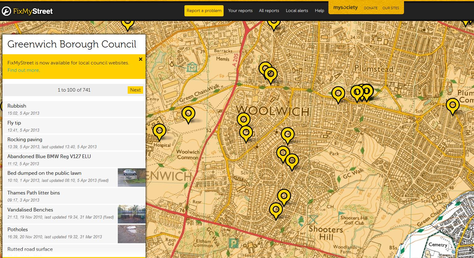
Another way of reporting fly tipping, and other problems, is to use the FixMyStreet web site, which will then forward the report to the council. This can be done either by entering a post code or interactively using their map. It allows you to attach photographs of the problem too. On FixMyStreet you can easily see all the problems reported in your area, as shown in the screen grab below.
Snippet from FixMyStreet web site
I wonder how long Mayplace Lane has been there? It’s intriguing that it runs from the Plum Lane Bronze Age Barrow, one of what was once a barrow cemetery of 6 barrows, down to the Woolwich Marshes. Recent archaeological finds at the Plumstead Crossrail site have suggested that Bronze Age people may have built wooden causeways across the Plumstead Marshes similar to those that spanned the marshlands of the Somerset levels. Bronze Age remains have also been found just over the river in North Woolwich. During the Bronze Age it is believed that people distinguished between the land that they lived in and farmed – the land of the living- and the land of the ancestors where their burials took place. Could Mayplace Lane have been their route from their villages around the Woolwich and Plumstead marshes up to the sacred Shooters Hill summit, the land of their ancestors?
Festival audience in Bhutan, where they measure Gross National Happiness
Our well-being is average, those of us living in the Shooters Hill ward, according to figures from the Greater london Authority’s London Datastore. Their composite values for the probability that people living in the ward will have higher well-being are built up from 12 different measures:
Health – Life Expectancy, Incapacity Benefits claimant rate Economic security – Unemployment rate, Income Support claimant rate Safety – Crime rate, Deliberate Fires Education – GCSE point scores Children – Unauthorised Pupil Absence Families – Children in out-of-work families Transport – Public Transport Accessibility Scores Environment – Access to public open space & nature Community – Elections Turnout
The average value for England and Wales for this measure of well-being is zero, which is what the Shooters Hill value for 2010 worked out to. Shooters Hill had the third highest score in Greenwich, as can be seen in the spreadsheet snippet below, but was 270th out of 625 London wards. The highest Greenwich well-being score was +5 for the Eltham North ward and the lowest, -14, for Woolwich Riverside, which was 619th out of the 625 wards across London.
Compared to other boroughs Greenwich residents don’t do so well, as the map snippet below shows, with most wards having a well-being probability below average. Well-being probability values are higher in some nearby boroughs such as Bexley and Bromley. Not surprisingly the London ward with the highest well-being probability was Knightsbridge and Belgravia in Westminster borough, and the top ten included 4 wards from Merton, 3 from Richmond upon Thames and one each from the City of London and Kensington and Chelsea. In general the indicators of well-being have a negative correlation with indicators of deprivation, such as the Ward Level Indices of Deprivation published by the GLA, but also with individual data items such as the Income Support Rate and the Unemployment Rate. In simple terms, the more deprived the ward, or the higher the level of income support or unemployment the lower the well being probability and the lower the indicators of well being such as life expectancy.
Snippet of London Ward Well-Being Scores Map
The life expectancy data were particularly striking indicators of the differences between wealthy and poor areas of London. The Greater london Authority’s well being figures are based on an average of the male and female life expectancy figures; a more detailed breakdown of ward level data is contained in the ward profiles dataset. In the gender averaged life expectancy figures people living in the Shooters Hill ward have the longest life expectancy of any ward in Greenwich, with the 2005-2009 life expectancy of 82.1. The lowest in Greenwich is Glyndon ward at just 75.3 – a difference of nearly 7 years! The highest life expectancy across London is an ancient 96.4 years in the West End ward of Westminster borough, and the lowest a mere 74.1 in the East Ham ward in Newham. So people in one of the wealthiest areas of London can expect to live over 14 years longer than we in Shooters Hill, and over 22 years longer than people living in East Ham!
Average Life Expectancy for Greenwich Wards against Index of Deprivation
The Greater London Authority criteria I’ve used are not the only way of measuring well-being. The Office for National Statistics also have a programme to develop measures for national well-being, which is graphically represented in their Wheel of Measures. This programme was kicked off by David Cameron in 2010. The ONS use a larger set of data items in their well-being assessment:
Individual well-being, e.g. Percentage with medium/high rating of satisfaction with their lives overall Our relationships, e.g. Average rating of satisfaction with family life (1-10) Health, e.g. Healthy life expectancy at birth, Percentage who reported a long term illness and a disability What we do, e.g. Unemployment rate, Percentage who were somewhat, mostly or completely satisfied with their job, Percentage who volunteered more than once a year Where we live, e.g. Crimes against the person, Percentage who felt very or fairly safe walking alone after dark Personal finance, e.g. Percentage of individuals living in households with less than 60 per cent of median income after housing costs Education and skills, e.g. Percentage with five or more GCSE’s A*-C incl English and Maths, Percentage of UK residents aged 16 to 64 with no qualifications The economy, e.g. Real household actual income per head, UK public sector net debt as a percentage of GDP, Inflation rate (as measured by the Consumer Price index) Governance (involvement in democracy and trust in how the country is run), e.g. Percentage of registered voters who voted The natural environment, e.g. Total greenhouse gas emissions (millions of tonnes), Air pollutants – PM10 (000’s tonnes), Energy consumed within the UK from renewable sources
Although the UK’s use of a well-being index has been criticised as being too woolly, and the ONS approach to the contributory metrics seems a bit scatter gun, I’m in favour of using other measures than GDP to assess how we are doing as a country. I’ve always been a bit uneasy about the idea that growth has to continue year after year. We can’t grow forever; eventually we will fill the planet and raw materials will start to run out. The idea that economic growth is more important than health or the environment seems very short sighted, and if followed to its ultimate conclusion would mean that one day we will only be able to see the great animals of Africa on a David Attenborough documentary. I also sympathise with the Skideslkys’ concern about insatiable, socially-generated conspicuous consumption: the observation that in wealthy countries such as the UK those who have enough to live on comfortably continue to work long hours to be able to acquire the latest gadget, or a bigger car or wider TV. The Skidelskys also define a “good life”, a kind of well-being at the personal level.
Bhutan is credited with being one of the first countries to downplay GDP as a measure of success, in favour of Gross National Happiness – their measure of well-being. As wikipedia says: “The four pillars of GNH are the promotion of sustainable development, preservation and promotion of cultural values, conservation of the natural environment, and establishment of good governance.” The Bhutanese use GNH to guide their policies; one reason they are supporting conservation initiatives such the Tiger Corridor which featured in a BBC TV programme recently. Bhutan is also one of the most photogenic countries I’ve visited, so I’m pleased to have the chance to use some of my photographs of the Pholay Molay dance at Wangdue Phodrang Dzong in Bhutan.
The Pholay Molay dance at Wangdue Phodrang Dzong in BhutanThe Pholay Molay dance at Wangdue Phodrang Dzong in Bhutan
The Junction of Shooters Hill Road and Well Hall Road
Well Hall Road on the South Circular could be closed for another two days while Thames Water fix a burst water main near the junction with Westmount Road, just outside the entrance to Greenwich Cemetery. The road is closed from the Well Hall roundabout to Shooters Hill Road for all but local access traffic.
This had led to traffic jams and long delays in the last couple of days as traffic tries to find a way round the blocked section of the busy South Circular Road. Last night it took me almost 15 minutes to drive from the Well Hall Road traffic lights up to the Bull because there was so much stationary or slow-moving traffic. Alternative routes are quite a distance – either via Falconwood to the east or westward down to the A2, as you can see on the Google Maps snippet below.
Google Maps snippet showing the blocked section of Well Hall Road
It is possible for non-HGV traffic to get round the closed road by going down Broad Walk and along Rochester Way, and north-bound traffic is directed this way by Diversion signs. However Broad Walk is a residential road, with speed bumps, cars parked on both sides of the road and a seven foot width restriction at the Well Hall Road end, so is likely to be congested in the rush hour.
Burst water mains seem to be a big problem in the current cold weather. According to an article on the Utility Week web site numbers have increased in London and the Thames Valley by 50% since the start of December, with about 1000 leaking or burst pipes being reported to Thames Water.
Update: Well Hall Road will definitely be closed 13/12/2012 and 14/12/2012, @ThamesWater tweeted: “Hi, the repairs are still ongoing, the road will be closed tomorrow. Sorry for the inconvenience. Shaun” and “We were informed yesterday that it would be closed for another 2 days, so tomorrow should be the last day. Thanks Kate ”
Further update: The road was fully open this afternoon, 13/12, so I guess they must have finished quicker than expected.
Google Maps' view of Christ Church School and the common land meadow behind it
A public inquiry will be held on the 8th and 9th February into the proposal for Christ Church School to use common land on Eltham Common. The Planning Inspectorate’s notice of the meeting states:
Proposed works on Eltham Common CL40
London Borough of Greenwich
Application reference number – COM 219
Ms Heidi Cruickshank, an Inspector appointed by the Secretary of State for Environment, Food and Rural Affairs will attend at The Public Hall, Woolwich Town Hall, Wellington Street, SE18 6PW on Wednesday 8 and Thursday 9 February 2012 to hold an inquiry into an application by Pellings LLP on behalf of London Borough of Greenwich for consent under Article 12 of the Ministry of Housing and Local Government Provisional Order Confirmation Act 1967 to carry out works on Eltham Common (CL40).
The proposed works comprise the formation of new hard and soft play areas consisting of playground (245 square metres), multi-use games area (858 square metres), soft/grass play area (660 square metres) and new planting (55 square metres and 48 square metres). All areas to be enclosed by fencing (2.1 metre high by 44.5 metre long and 2.7 metre high by 51.7 metre long weld mesh fence) and railings (1.5 metre high by 73.75 metre long painted metal) with gates. A new footpath will be formed from Shooters Hill Road alongside the existing school to the school and new play areas.
The inquiry will begin at 10.00am on Wednesday 8 February 2012. Anyone can attend the inquiry. Anyone who wants to be heard on the subject matter of the application may, at the discretion of the Inspector, give evidence at the inquiry or arrange for someone to do so on his or her behalf.
Copies of the application documents, representations, and plan can be inspected at Eltham Centre Library, Archery Road, Eltham, SE9 1HA (not public holidays). Copies of the application documents and plan are also available on request from the Planning Inspectorate, Room 4/05, Kite Wing, Temple Quay House, 2 The Square, Temple Quay, Bristol BS1 6PN
The original application for the school’s rebuilding work and creation of a play area and muga court was approved by Greenwich Council in November. (What’s a muga court? I had to look this up – wondering whether muga was a new game, some kind of Nepalese Quidditch perhaps – but it’s just a Multi-Use Games Area). Unfortunately the revamp of the Greenwich Council web-site means that the original documentation is not currently accessible, but the notice above summarises the issue – the use of a 50m by 40m area of common land for a games area for the school when the school buildings are extended into their existing play ground. The area is the field behind the school, alongside the track that leads to Severndroog Castle. The Google Maps snippet above shows the area quite clearly. By my reckoning 50m is perhaps half the length of the meadow.
Campaigners against the proposal point out that Eltham Common is designated as Metropolitan Open Land, an Area of Special Character of Metropolitan Importance and part of the London Green Chain. Significantly it is also Registered Common Land, which is why there has to be a public inquiry into the proposed changes. Dr Barry Gray gives the details of the reasons for objection in an interview in the Plumstead Common Environment Group Newsletter, arguing, among other factors, that:
The proposed grassland area on which the MUGA pitch is proposed to be built is in an area which is extremely important for nature conservation. In the Greenwich Borough plan it is designated as a Site of Nature Conservation Importance of Metropolitan Importance. This means that it is in the highest category in London and its retention as an ecologically sensitive area is important for London as a whole. I have already alluded to the importance of this site and I think you should bear this in mind when looking at the ecological impact and the landscape impact of the proposed inappropriate development. To quote the Greenwich Borough plan policy 018 “a network of sites of nature conservation importance throughout the borough have been identified for protection”.It seems to me to be a strange form of protection to propose to cover most of the site, in this instance, with hardstanding material for what is, in effect, a fenced soccer pitch.
But, and this is a big but, Christ Church School needs to be able to expand its current accommodation for staff and pupils. It is cramped in its current building, but despite this the school was rated Grade 1 – Outstanding – in its last Ofsted Report. And the area of land involved is quite small when set against the size of Eltham Common, not to mention the totality of the common and woodland area across Shooters Hill.
Although Greenwich Council’s decision to approve its application for the Equestrian Centre next to Woodlands Farm isn’t, and shouldn’t, be a factor in the Planning Inspector’s decision, I feel it complicates the issue. The Equestrian Centre will also be built on Metropolitan Open Land. It feels like the council is gradually chipping away at the area’s Metropolitan Open Land, paying no respect to its own rules and guidelines set out in the Unitary Development Plan. It prompts the question what will they grab next? Personally if there was a choice between building an Equestrian Centre that won’t provide much benefit to the local community, and allowing an outstanding school the space it needs to do its job I’d have no hesitation choosing approval of the school’s plans.
It should be an interesting Inquiry meeting; I don’t envy the Inspector her decision.
The proposed free school for the area was mentioned in the newsshopper today in an article by Mark Chandler which reveals that the growing population of the borough is putting pressure on primary school places, with apparently 300 pupils still without a school place for next September.
…Mum-of-two Mary Pfeiffer, who is setting up her own Shooters Hill Primary School of Arts, said she was surprised, having been told by the council that the borough had enough places.
She said: “This is something that frustrates me.
“One of the main reasons for wanting to set up the free school is parents have been having issues trying to get children into their choices.
“My children are now in Bexley – we couldn’t find a place in Greenwich for them to go.”…
Oddly enough, the population projections in the 0-5 age range for Shooters Hill Ward predict a decline in numbers over the 2001-31 period.
The borough wide projections tell a different story however, with an increase of almost 10,000 under 5’s in the 2001-31 period (despite a population fall recorded in the 2001 census).
In any case, the pressure on school places is going up, and with youngsters from across the borough coming to schools in Shooters Hill, the predicted reduction in numbers of local pre-schoolers will probably not aversely affect the case for the opening of the Free School, which will not have an explicit catchment area, and will in all likelihood take pupils from as far away as their families are prepared to make a school run.
The fact that this event has been going since 1978 only to be stopped now just goes to show how severe the cuts are; and as one of the important elements of ‘social glue’ that binds the fabric of Plumstead society together, the make merry’s loss is also our loss.
Despite this, the rallying of local people to bring back the festival in 2012 has already begun, and a benefit gig on the evening of the 16th of April at Plumstead Pavilion has been arranged as the first step on the way to the future. According to the newsshopper report, the council have offered to try and help with applying for lottery funding, as they begin to concentrate investments in potentially lucrative projects such as the forthcoming greenwich summer sessions.
It is with great disappointment and regret that the organising committee for the Plumstead Make Merry have to announce that there will not be a Make Merry on Plumstead Common this year. Due to central government cuts in local authority funding, Greenwich Council have been forced to cut the funding on which the Make Merry has depended on for its infrastructure. The committee is made up of local people who all volunteer their time and efforts for free, we do not make a profit, and proceeds from our tea tent and stalls are spent on staging, marquees, sound equipment and on providing free activities for children.
The Plumstead Make Merry has been held on Plumstead Common every year for the last 32 years. It is the most eagerly awaited local event, and the longest running event in the borough. Last year, over 6,000 people visited the festival. We, the Plumstead Make Merry Committee are devastated that there will not be a festival this year, and we know that we are not alone in this feeling.
The Plumstead Make Merry is an important event in the community calendar. We provide a unique opportunity for local charities, voluntary organisations and small businesses to raise awareness of the services, products, information, advice and guidance that they have to offer. As well as this, the Plumstead Make Merry strives to ensure that everyone in our diverse community has the opportunity to be involved. Our funding cut will have an impact on everyone that lives in Plumstead, and beyond.
The Plumstead Make Merry is a celebration of our vibrant, talented and diverse community and will be a great loss to thousands of people. Generations of families have attended the event but due to our lack of funding will not be able to do so this year. The summer of 2011 in Plumstead won’t be the same this year without the Plumstead Make Merry.
However, we will rise above the cuts. We could spend our time and energy complaining about the cuts and campaigning against them – but we won’t, there are many other cuts happening within the borough and nationally, instead, we are dedicated to ensuring that a Make Merry will take place next year. We are appealing to you, the community, to help us.
Throughout the year we will be fundraising and making sure that the Plumstead Make Merry stays in the hearts and minds of local people. Don’t forget the Make Merry, it’s an event put on by local people for local people, it is your celebration of our community.
We are determined to show that the community is bigger than the cuts, and that we can survive. We appeal to everyone to support our fundraising events so that the 2012 Plumstead Make Merry will go ahead, whatever happens with the budget cuts.
We have a great night of entertainment planned for Saturday 16th April 2011 when the ‘Benefit Bash for the Plumstead Make Merry’ will take place in the Greenwich Rugby Club Pavilion on Plumstead Common, (Old Mill Road, London, SE18). Entry will cost just £5 at the door and all proceeds will go towards supporting the festival. There will be live music, karaoke, disco and fun and games. The fun starts at 7:30pm, and we hope to see you all there!
The next event is on Saturday 11th June 2011 – the day the Plumstead Make Merry was due to take place. It will also take place at the Greenwich Rugby Club Pavilion on Plumstead Common, and for a small donation of £5 you can expect a day and evening of non-stop entertainment.