Seven Centuries of Signalling

Lambarde's Carde of the Beacons of Kent
Lambarde's Carde of the Beacons of Kent. Shooters Hill is top left

The number of communications masts around the summit of Shooters Hill are a testament to the hill’s appeal as a communication centre. However the hill’s height and prominence, which make it attractive for modern wireless communication, coupled with its position guarding the route from London to the coast, have made it appealing to communicators for centuries.

The marvellous Colonel A.H.  Bagnold CB CMG tells a vivid and dramatic story of the hill’s role in message transmission before the advent of wireless communications. He places the start of its role as a Beacon Hill before the reign of Edward III (1312 – 1377), so about seven centuries ago. The complexity of the beacon system in Kent at the time of the Spanish Armada was plotted, on the map (or carde) shown above, by William Lambarde, who also founded the Queen Elizabeth College almshouse in Greenwich. Lambarde published the map in his book The Perambulation of Kent, credited as the first English county history, describing the reason it was drawn and how it could be used to decide the direction in which danger had been detected:

AS in warre, celeritie availeth no lesse, than force it selfe: So the Right honorable Sir William Brooke, Lord Cobham, and Lorde Chamberlaine of hir Majesties houshold (who hath been sole Lieutenant of this shire, since the first of hir Majesties Raigne) foreseeing how necessarie it was to have the forces of the countrie speedily draw togither, for the encounter of any hostilitie: and finding, that upon the fiering of the Beacons (which are erected for that service) not only the common sort, but even men of place and honour, were ignorant which way to direct their course, & therby (through amasednesse) as likely to run from the place affected, as to make to the succour of it: caused the true places of the Beacons to be plotted in Carde, with directorie lines, so many sundrie waies, as any of them did respect the other: By which, any man, with little labour may be assured, where the danger is, and thereof informe his neighbours. For example: suppose our first Beacon, standing on Shooters hill, to be light: he that will go thither may know by the watchmen from whence they received their light, which must be either from the West neare London, or Hamstede: or else from the East, by warrant of the fiered Beacon at Stone neare Dartford, or of that which is neare to Gravesende. The like of the rest: and so much for use.

Bagnold also describes the 1747 experiment in telegraphy using static electricity conducted on Shooters Hill by Dr Watson, bishop of Llandaff. The “observers” of the transmission stood on (insulating) amber while holding an earthed iron bar in one hand and the end of the two-mile long transmission wire in the other. A gun was fired when the transmission started and the observer timed the difference between when they heard the gun and when they received an electric shock!

Semaphore Station - the Murray Shutter telegraph

Shooters Hill was a link in the next advance in communications as well – the Semaphore line. This used a set of rectangular frames containing six 5 foot high shutters to transmit messages between London and the coast. The first to be completed was between London and Deal in January 1796, with the following chain of stations: Admiralty (London), West Square Southwark, New Cross, Shooter’s Hill, Swanscombe, Gad’s Hill, Callum Hill, Beacon Hill (Faversham, branch point), Shottenden, Barham Downs, Betteshanger, Deal. The New Cross station was situated on Telegraph Hill – the Telegraph Hill Society’s web page includes a copy of a water colour sketch of the telegraph station, with the Shooters Hill station just visible in the distance.  As can be seen in Pocock’s wood-cut below,  the Shooters Hill station was on the ridge of the hill in an area known as Telegraph Field, which is now the site of the Memorial Hospital.  (You may recognise the top of this picture because it used to form the banner picture for this blog). At its best this line could send a signal from London to Deal and back in two minutes. Perhaps this was the inspiration for the Disc World Clacks system which featured in various of Terry Pratchett’s books, such as the magical “Going Postal”, though the Ankh-Morpork system seems to have been considerably quicker than the UK Admiralty’s!

R Pocock of Gravesend's woodcut of the Shooters Hill Gibbet  showing the Admiralty telegraph in the background (circled)
R Pocock of Gravesend's woodcut of the Shooters Hill Gibbet showing the Admiralty telegraph in the background (circled)

In the present day, as can be seen from the Ofcom mobile phone base station database, many of the communications masts on Shooters Hill are mobile phone or emergency service communication masts, including the Eaglesfield Road mast by the old fire station that was opposed by local residents led by SHAM.  There are even mobile phone antennae attached to

Water Tower and Oxleas Wood Mast
Shooters Hill Water Tower and the Oxleas Wood Mast

the windows  of the Victorian Water Tower at the crest of the hill – also opposed by local residents. However not all the masts are for mobile telecommunications. Some are thought to be communications systems for taxis or the ambulance service. The mast that can be seen behind the dairy in Foxcroft Road has been identified as a transmission mast for FM and DAB radio, for example the Digital One multiplex which carries a number of DAB channels including Talksport, Absolute Radio and Classic FM.

The Port of London Authority, who worryingly are advertising on their web site the availability of mast sites on Shooters Hill to telecommunications companies, have a mast just off Shooters Hill Road. This mast is a base station for the Automatic Identification System (AIS) which is used to identify and locate ships around the world, for example as shown in the map below from the Marine Traffic web site. The PLA mast also has a direct microwave link to a PLA Vessel Traffic Services (VTS) radar station at Blackwall Stairs, just across the river from the O2 dome.

Ham Radio enthusiasts also take advantage of Shooters Hill’s prominence, for example the Cray Valley Radio Society 2010 Summit was held in the highest pub in South London, the Bull at 416.7ft. The Society will be holding a Christmas Social Evening in the Bull in a couple of weeks time on Thursday 15th December 2011.

What next for communications in Shooters Hill? Well the 4G, or Long Term Evolution (LTE), technology is being trialled already – one trial by O2 includes the area around the Dome and Canary Wharf as well as central London. Live networks aren’t expected until 2014 beacause the frequencies won’t become available until analogue TV is switched off next year, but we can expect masts  to be upgraded beforehand. And after that …. who knows, but I wouldn’t be surprised if Shooters Hill was still a communications centre.

Marine Traffic map of waters around South-east UK showing ship locations
Ship locations in the Thames and round the Kent coast

pMap 1.1

Welcome to pMap v1.1. It’s a minor update on 1.0 which makes use of slightly neater scraping which is faster to relay; allows toggling of wards; allows re-centering of the map. It’s currently working on the previous 7 days’ planning applications registered. You can see the source code below, or fork it.

pMap

Continue reading “pMap 1.1”

pMap

Welcome to pMap (planningMap). It currently offers this service: take the previous 28 days’ planning applications to lbg, map those that can be geo-coded (by postcode), and list those that can’t. You can read a bit more about it and check the source code below.

pMap

Continue reading “pMap”

Human Geography: Gender Differences

Over the last two years that this site has been going, some useful and/or interesting maps have been added to the archives, unfortunately the ones which are just about to be added don’t really say anything in particular about the hill, although as a follow-up from the google based maps that went up a while ago, it’s a further method for ploughing through census data which might eventually reveal something, possibly.

Making ward maps can be done within-borough using ons and nomis, but because Shooters Hil is a frontier zone on the London Kent border, it’s worth considering similarities/differences with nearby Bexley wards too, with East Wickham being our nearest neighbour. Most out-of-the-box mapping programs don’t seem to be able to do this, concentrating instead on showing what’s happening within each Borough (presumably for strategic reasons). However, sometimes things don’t really work at the borough level, for instance although Shooters Hill regularly has the lowest crime rate in Greenwich (sometimes coming second to Coldharbour), the levels reported are roughly equivalent to, or even slightly more than those in nearby Bexley wards. So there is a reason for comparing wards in this way.

The maps shown below highlight gender population divisions during the stages of life from the age of 0–99, without really differentiating Shooters Hill from its neighbours in any meaningful way. What the maps do show are the wider trends, such as that in the first 20 years of life there tend to be more slightly more boys than girls (especially in Eltham North), and that subsequently this difference reverses. This could mean that after 20, more girls move into this part of the world, more boys leave, or perhaps that more girls return their census forms. Above the age of 70 women seriously begin to outnumber men, and this is an indication of gender differences in longevity. Perhaps as a result of this, the overall figures show that there are slightly more women than men in this whole area, with about 3% in it (at most). Interestingly, Eltham North stands narrowly apart on this measure, and this is possibly due to the slightly greater percentage of boys in the early years.

The colour scaling on the maps does tend to make differences appear quite strong, even when they’re not, and the gender divide is essentially the same everywhere — also the colour scaling is different on each map, making it harder to compare them to each other. By looking at correlations, the overall pattern in Shooters Hill is most like that of Kidbrooke and Hornfair, and least like that of Woolwich Common, although correlations are all very strong, and differences are negligible.

To sum up, gender differences do not show meaningful ward differences, with the most apparent difference being that Eltham North is a tiny bit less feminine than the other wards due to its concentration of young boys. Oh well, it was worth a try, there are after all over 100 more census measures to go through, by which time the new census will have come out (next summer), and it can start all over again…not really, the site hasn’t done much with local history for a while, and some readers were promised more on the woods Vs motorway story a long time ago, so the census can wait a bit for now.

Hover over the small maps to zoom in

Mapping: Neighbouring Electoral Wards

Partly thanks to the bank holiday weather, various maps got made today.

These were made from a cache of open data stored by the democratising technologists over at mysociety. Among other things, they are responsible for the theyworkforyou website, which makes it easy to find out what MPs get up to. Over the last few weeks it’s been possible to learn that Clive Efford is extremely angry about the NHS fiasco, in fact he’s made himself heard in no uncertain terms, and it wasn’t just theyworkforyou that have been syndicating his speeches, but the radio four today programme – in case you were wondering, it was him asking the Lib Dems if they were going to have a spine and vote against the health cuts… He’s also been hot on the trail of the Localism bill, in particular with regard to how it affects the provision of enough allotments at an affordable rate, something that may have come to his attention as a result of the recent price hike introduced by the Local Authority (it’s quite possible that some people have complained to him about this and he’s investigating further). The story behind the increase goes like this: LBG allotments cost £80000 to administer; 15 sites (769 plot holders) currently provide £20000 in rentals, so the near fourfold price hike will make up the shortfall. In any case, under the Localism bill, it may be that some areas end up less allotments, and some with more, who knows?

Anyway, the mysociety people also provide a lot of mapping tools, and store all british political boundaries in digital form for free. Having got this great big national dataset, it took a bit of fiddling to extract local ward boundaries using R (also free). If you would like to do any mapping and with the local boundaries as kml or shapefiles please drop us a line.

The general idea was to use the maps to run comparisons between Shooters Hill and neighbouring wards using 2001 census data, and when the 2011 census comes out, some historical comparisons can follow.


View Shooters Hill Neighbouring Wards dwellings in a larger map

The first comparison is number of dwellings (i.e. postal addresses) in 2001. In comparison to neighbouring wards, Woolwich Common has the most, presumably because of the flats, whilst East Wickham (Bexley) has the least, more than a thousand less than any other ward. It’s quite a small area, and includes farmland and open space, and so it becomes clearer that comparing areas on counts rather than proportions might be a bit inappropriate, so mapping dwellings to land might be a better comparison to make, still it’s a start. The colour scaling is also a bit problematic, as the smallest measure is translated into zero colour, which stands out a bit more than it should…


View Shooters Hill Neighbouring Wards Population in a larger map

This map shows the number of people in each ward, compared (using colour scaling) relatively between these wards only. The lowest number of people was in East Wickham, and the highest in Plumstead, which suggests that some of the many flats in Woolwich common are either empty or have relatively few occupants.


View Shooters Hill Neighbouring Wards Average Age in a larger map

This map shows the average age of the population, and East Wickham comes out top for a change, with an average age of 40, whilst areas such as Shooters Hill have a lower average age, presumably as they have more young people, which pulls the measure downwards.

Well, that was the first attempt at doing some basic demographic mapping – and it’s not really conclusive, but it does certainly seem to show that the differences are strongest between the 6 wards in Greenwich and the 1 in Bexley, East Wickham, which has the least houses and people, and the oldest average age.

No Crossrail in South East London

crossrail

The Proposed Crossrail Route (tunnels in red)

Well, the banking crisis is strongly starting to make itself felt in the selondon area now. This week, various blogs (including london reconnections and 853), have covered a recent commons debate that was secured by nick raynsford, and rather defensively fielded by the new minister for transport, theresa villiers (a tory i think). The debate was on the future of crossrail in woolwich specifically and possibly selondon as a whole, and it’s not looking good. The inclusion of Woolwich in the scheme was originally achieved on the back of a 2008 assurance by Berkeley Homes to pay £150 million for the station, which helped the public by reducing government spending on getting the line from Canary Wharf to Abbey Wood. Now it seems that Berkeley Homes are struggling to meet their commitments, because of the banks, and the Government look likely to use this to justify the dropping of the woolwich terminal or the entire selondon spur from the programme.

Obviously people can still get to East London and the City via the wonderful new DLR line from Woolwich Arsenal Station, and Villiers made a point of this, but Raynsford then pointed out that instead of the 2.4 million predicted journeys in year one of woolwich DLR, there were actually 5 million through this station; anyone who uses it in the rush hour will know that overcrowding is a problem. Furthermore, Crossrail would have been really good for links with other parts of London (see map), and would have been a much more popular and clean connection with our neighbours in the east than the proposed thames gateway bridge would have been.

Villiers closed the debate by washing her hands of Berkeley Homes, whilst saying that she would try to help Greenwich Council and other ‘interested parties’ to try to help Berkeley:

I know that Greenwich council is actively engaged in the issues that we have discussed this evening. It is now important for all of us who care about Crossrail to assess thoroughly the possible alternative funding sources that could be available between the interested parties if Berkeley Homes does not step up to the plate and deliver what it promised. Therefore, while I cannot promise additional funding from the Department and the taxpayer, we do stand ready to try to help the interested parties find a solution to enable Woolwich station to go ahead. The right hon. Gentleman can have my absolute assurance on that.

Who these ‘interested parties’ are I’m not sure, I suppose I am, but i’m not really in a position to lend Berkeley 150 million, and I doubt if Greenwich Council are either. I hope that Canary Wharf (who are also paying for their station) consider standing Berkeley the cash, considering the massive profits currently enjoyed there, might they be persuaded?

… I fear that if Woolwich goes, the entire selondon spur will be sacrificed.

Don’t worry though, Villiers offered this by way of consolation:

…it is worth noting that several important programmes in recent years have benefited his [nick raynsford’s] constituency, such as the refurbishment of the East London line as part of the London overground network [hmm, brockley isn’t in raynsford’s constutuency], new interchanges with the tube and bus networks [the dome?], and the extension of the docklands light railway [yes, it’s brilliant, but overcrowded at times].

She forgot to mention that the waterfront transit scheme has also been dropped…

Red Lion Lane One Way Proposal

Red Lion Lane - One Way Proposal

Highway safety seems to be fairly active theme in the area at the moment, there was the traffic monitoring in cleanthus road last year (not sure what came of that), and the extension of the 20 mph zone to eaglesfield road; now there’s a new speed/vehicle counter on the hill going down to kent, plus the occasional traffic police with lidars round the garden centre, and the new road safety improvements to shrewsbury lane where it meets the main road plus the pedestrian refuges at various stages, and the proposed double yellow lines on the main road round the farm (this will save people getting parking fines when they drive to the lambing day in april)…

Overall it just goes to show that gene selection for fear of spiders and snakes, useful though it may have been in the ancestral environment, is now being replaced by meme selection – i.e. we’re just not scared enough of vehicles yet, so culture has to intervene whilst we wait for the genome to catch up (i.e. all the people who are afraid of cars reproduce more effectively than those who aren’t).

In 2000 Red Lion Lane benefited from traffic calming as part of the 20mph traffic calming measures enjoyed by many roads in the area, and was also turned into a down-the-hill-only road at the top end. At the same time the idea of excusing pavement parking on the bottom end was briefly considered before being, erm, parked. Since then the council have received a number of complaints about drivers having difficulty passing each other on this lower section of the lane, and also complaints about damage to parked vehicles, which presumably happens when things get tight. Efforts have been made to revive the pavement parking idea, but now a more radical measure is being proposed which is to make still more of the lane down hill only.

A mini vote is currently on, mainly to sound out the feelings of those who live on roads that will get the up-hill traffic that currently use red lion lane as a rat run when the junction at the old shooters hill police station gets slow, and so I anticipate that herbert road→paget rise→ankerdine crescent→shrewsbury lane→foxcroft road→eaglesfield road will now become the cut through of choice for those in an, erm, hurry. The other way that through traffic might cut through would be herbert road⇒ripon road⇒eglinton hill⇒eaglesfield road – so it may be that residents in these roads are being polled.

People Against the River Crossing: Were You There?

people against the river crossing
People Against the River Crossing

July the 8th 1993, central government withdraws the Oxleas Woods section of its infamous Roads to Prosperity scheme. The hill is saved!

I’ve been asked whether I’d like to investigate this, and since this is quite possibly one of the most significant things to ever happen here, it seems like a good idea for this site to cover this part of the Shooters Hill story.

Since this is a relatively recent episode, and an example of people power, I’m hoping to include some thoughts from those who participated in and observed the saving of the woods. So, if you were there, and would like to reminisce, I would like to hear from you. If you are interested please get in touch via the email address at the foot of the page.

parc-maps

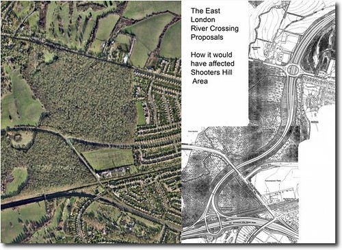
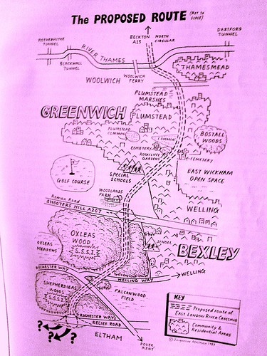
The map shows how the bypass would have run right through woodlands farm, oxleas wood, and sheperdleas wood to meet the a2

At some point this year a post on this will appear, but for the time being, here’s the oxleas section of an alarm uk publication from 1995 (taken from the limited online information I’ve found so far):

“Whenever I used to visit Oxleas Wood I would visualise the proposed road cutting through it. It’s hard to believe that the woods are now safe. But safe they almost certainly are!

My involvement in the campaign against the East London River Crossing began in earnest in the late eighties. By this time the road had been scheduled for construction for many years and had already been approved by the longest Public Inquiry ever held into a road scheme. That inquiry had lasted 194 days; the transcripts of the proceedings contained 9.5 million words!

Local people, in the form of People Against the River Crossing (PARC) and Greenwich & Lewisham FOE, were fighting a determined and exhausting battle against a scheme which would not only cut a swathe through 8,000 year old Oxleas Woods but would also take out several hundred houses in the quiet and pleasant suburb of Plumstead. But with approval in principle granted, and with the Government, developers and some socialist local authorities strongly supporting the scheme, the odds against stopping it were getting bigger all the time. To achieve victory, a concerted strategy was needed to make Oxleas Wood a big issue locally and give it wider significance – a strategy to make it a symbol of the environmental damage that the road programme was causing and a rallying point for the environment movement. If that could be done, then, given Oxleas Wood’s proximity to Westminster, it might force the Government to back down rather than risk confrontation with a united community and environment movement, in its own “back yard”.

Like all the best campaigns we fought on every level. There were letter-writing stalls at the popular Greenwich market, politicians were systematically lobbied and a well-presented public transport alternative was drawn-up. We organised an “Adopt-a- Tree” scheme; the aim here was to get every tree in Oxleas Wood adopted. As well as bringing in funds and publicity, it would give supporters a real stake in the campaign. And if the worst came to the worst we could invite tree adopters to turn up to defend their tree.

In order to make Oxleas a “line in the sand” for the environment movement, we got some of the large environmental non-government organisations (for example the Wildlife Trusts and World Wide Fund for Nature) to take part in an Oxleas Strategy Group. This helped lock them into a campaign that was ultimately run by local people, but which made the best use of the resources of the national campaigns.

A couple of legal lines of last resort helped propel the campaign into the national news. The Government had failed to carry out an Environmental Impact Assessment for the scheme, as required by European Community law. The heroic European Commissioner for the Environment, Carlo Ripa di Meana, took up this complaint causing Prime Minister Major to hit the roof and interrupt a Commonwealth conference to condemn the EC’s action. The complaint was never seen through by the EC, but the publicity was invaluable, as was that which resulted from a High Court case where the “Oxleas 9” (nine local people) put their assets on the line to take the Department of Transport to court over their failure to provide adequate land in exchange for the damage to Oxleas woods. The case was lost, but Oxleas had caught the public imagination and the pressure on the government was intensifying.

Meanwhile, campaigners were preparing for the worst. A “Beat the Bulldozer” pledge was launched, with the aim of getting 10,000 people to pledge to be there if the bulldozers went in. With the TV pictures of direct action at Twyford Down fresh in their minds, as well as the vivid pictures we had painted of what would happen if they violated Oxleas Wood, the Government backed down.

For me the Oxleas campaign had meant hours of hard work in meetings held in draughty halls on dark, rainy nights trying to get the best campaign that I could. For hundreds of local people it had been years of struggle. Was it worth it? Definitely. Oxleas was a turning point. We’d shown how people power could stop roads, a lesson that was quickly learnt right across the country. We’d shown that the environment movement, when it’s focused and working in harmony with local communities, could win. And of course the peace and beauty of OxleasWood has been preserved.

Jonathan Bray, founder and convenor of the Oxleas strategy group

elrc-map

East London River Crossing Trunk Road

From the oxleas woodland management plan:

The Hedgerow on the eastern side of the meadow is composed of mainly hawthorn (Crataegus spp) with some self-seeded oak. This hedgerow is rather special as it contains some examples of butchers broom (Ruscus aculeatus), which is used as an indicator of ancient woodland, as it rarely grows in regenerated woodland. It was the presence of this plant that aided the campaign to stop the East London River Crossing putting a road through Oxleas Wood. This hedgerow was re-laid in 2004 by the GLLAB New Deal project.

Falconwood is on the TfL Map

Falconwood on the TfL Map

Part x in an occasional series on maps. This little beauty came via the mighty 853, who reported on the forthcoming oysterisation of overground train fares in this neck of the woods. Local stations are now included on arguably one of the all time classic maps, the present day version of the London Underground map, a.k.a the integrated TfL map. As you can see we have the blue line (charing x and canon st), and the green line (victoria) – I would have preferred primary colours myself, but they were all spoken for… I’m not mad on the parallel lines either, as they look a bit hollow, but I’m guessing the designers were trying to differentiate the overground services by tapping in to how people visualise train tracks.

In Mr 853’s post, the title of which contains the phrase the “great train robbery”, he also notes that fares are set to rise, let’s have a look:

  • Currently: A so called anytime single to London Terminals from zone 4 stations is £3.70, with peak/off-peak returns at £6.20/£4.70 respectively, (for all the confusing details about zone 1 connections, daily cap changes, changes to peak times etc see his pricing post) or the full proposed pricing document.
  • Presently: Comparative trips using oyster fares will cost £3.10/£2.30 (peak/off-peak) single, this is already significantly cheaper than £3.70!). Return prices will vary a bit depending on the time of travel (e.g. the dreaded afternoon peak from 4-7pm), but let’s consider a pleasant scenario for the sake of optimism: a nice little day trip to trafalgar square on a sunny weekend in january, with no onward connections from charing x: this will cost someone over 16 £4.60, which is actually cheaper than current fares by 10 pence.

There are various catches that even out the price differences, such as the premium train users pay if they connect with other TfL services in Zone 1, and apparently season ticket holders are going to pay extra, and there are further criticisms of south eastern trains in particular for not going above and beyond the call of duty by making eco-friendly travel to bluewater more accessible (as has been done for lakeside), but overall, it’s good to welcome in these long overdue changes.

Green Chain Walking Festival

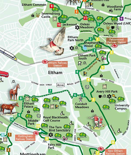
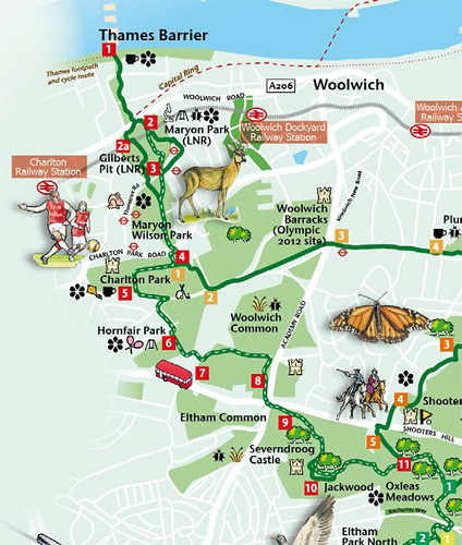
As part of the south east london Green Chain Walking Festival , a guided walk from Eltham Palace to the Thames Barrier is taking place that visits in Oxleas Woods and Severndroog Castle en route, tieing in with the Open House events there and at other stops along the way.

Walk London Audio Guides have been provided for the different sections of the chain, including those that make this pathway; although they go clockwise, this particular trek is being done the other way, presumably as it involves more downhill walking, well it is seven miles long after all! The guides make for curious listening, and even feature cameo appearances from boycie. I’ve put the audio alongside the maps, which include the Green Chain in red lines, and the Capital Ring route in yellow.